Property Record
2101 W Armitage Ave, Chicago, IL 60647
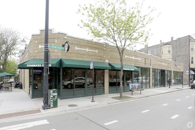
This Property Is For Sale
NEARBY LISTINGS FOR SALE OR LEASE
Property Detail
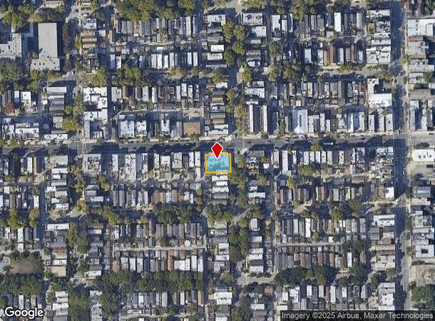
2101 W Armitage Ave
Chicago-Naperville-Elgin, IL-IN
Pierces Add To Holstein
14-31-304-038-0000
(PIERCES) ADD TO (HOLSTEIN) IN NH SW SEC 31-40-14
Commercialbuilding
Cook
X
Illinois
17031C0416J
27,26
2023
0.17 AC
2025
Northwest City
222200
Chicago
5,968 SF
DEMOGRAPHICS near 2101 W Armitage Ave
1 Mile
3 Mile
5 Mile
2024 Total Population
54,894
557,164
1,173,880
2029 Population
53,086
536,407
1,126,894
Pop Growth 2024-2029
(3.29%)
(3.73%)
(4.00%)
Average Age
34
36
37
2024 Total Households
25,637
272,256
548,962
HH Growth 2024-2029
(3.61%)
(3.61%)
(3.77%)
Median Household Inc
$126,414
$101,136
$87,604
Avg Household Size
2.10
2.00
2.10
2024 Avg HH Vehicles
1.00
1.00
1.00
Median Home Value
$617,287
$513,712
$431,382
Median Year Built
1950
1961
1957
Nearby Places
Map Layers
Map Styles
 Street
 Aerial
- Restaurants
- Banks
- Shops
- Fitness
- Groceries
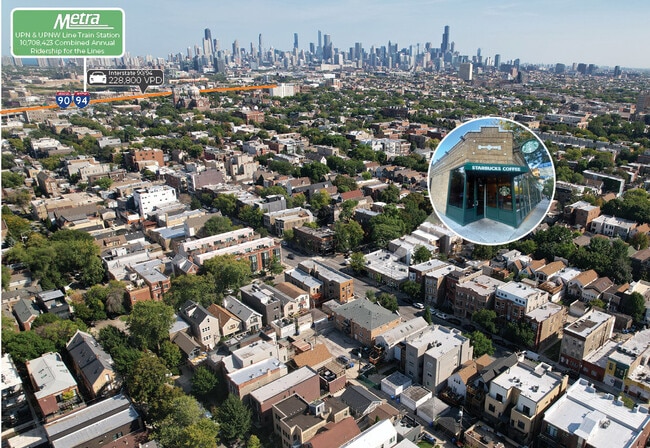
PUBLIC TRANSPORTATION
TRANSIT/SUBWAY
Western Station (Blue Line - O'Hare Branch) (Blue Line - Chicago Transit Authority "L" Trains (The "L"))
DRIVE
WALK
Distance
Western Station (Blue Line - O'Hare Branch) (Blue Line - Chicago Transit Authority "L" Trains (The "L"))
1 min
9 min
0.5 mi
Damen Station (Blue Line) (Blue Line - Chicago Transit Authority "L" Trains (The "L"))
DRIVE
WALK
Distance
Damen Station (Blue Line) (Blue Line - Chicago Transit Authority "L" Trains (The "L"))
2 min
12 min
0.6 mi
Clybourn Station (Union Pacific North Line - Northeast Illinois Regional Commuter Railroad (Metra), Union Pacific Northwest Line - Northeast Illinois Regional Commuter Railroad (Metra))
DRIVE
WALK
Distance
Clybourn Station (Union Pacific North Line - Northeast Illinois Regional Commuter Railroad (Metra), Union Pacific Northwest Line - Northeast Illinois Regional Commuter Railroad (Metra))
2 min
13 min
0.7 mi
California Station (Blue Line - O'Hare Branch) (Blue Line - Chicago Transit Authority "L" Trains (The "L"))
DRIVE
WALK
Distance
California Station (Blue Line - O'Hare Branch) (Blue Line - Chicago Transit Authority "L" Trains (The "L"))
2 min
20 min
1.0 mi
COMMUTER RAIL
Clybourn Station (Union Pacific North Line - Northeast Illinois Regional Commuter Railroad (Metra), Union Pacific Northwest Line - Northeast Illinois Regional Commuter Railroad (Metra))
DRIVE
WALK
Distance
Clybourn Station (Union Pacific North Line - Northeast Illinois Regional Commuter Railroad (Metra), Union Pacific Northwest Line - Northeast Illinois Regional Commuter Railroad (Metra))
2 min
13 min
0.7 mi
Western Avenue Station (MD-N/MD-W/NCS) (Milwaukee District North Line - Northeast Illinois Regional Commuter Railroad (Metra), Milwaukee District West Line - Northeast Illinois Regional Commuter Railroad (Metra), North Central Service - Northeast Illinois Regional Commuter Railroad (Metra))
DRIVE
WALK
Distance
Western Avenue Station (MD-N/MD-W/NCS) (Milwaukee District North Line - Northeast Illinois Regional Commuter Railroad (Metra), Milwaukee District West Line - Northeast Illinois Regional Commuter Railroad (Metra), North Central Service - Northeast Illinois Regional Commuter Railroad (Metra))
7 min
2.7 mi
AIRPORT
Chicago Midway International
DRIVE
WALK
Distance
Chicago Midway International
22 min
11.6 mi
Chicago O'Hare International
DRIVE
WALK
Distance
Chicago O'Hare International
22 min
14.1 mi
Nearby Properties
Address
Land Use
TOTAL SIZE
Lot Size
Zoning
Address
Land Use
TOTAL SIZE
Lot Size
Zoning
1,502,279 SF
3.79 AC
PD 98
Address
Land Use
TOTAL SIZE
Lot Size
Zoning
1,857,394 SF
3.13 AC
PD 447
Address
Land Use
TOTAL SIZE
Lot Size
Zoning
1.09 AC
B1-3
Address
Land Use
TOTAL SIZE
Lot Size
Zoning
559,589 SF
1.72 AC
C3-5
Address
Land Use
TOTAL SIZE
Lot Size
Zoning
0.72 AC
PD 1403
Address
Land Use
TOTAL SIZE
Lot Size
Zoning
73,700 SF
0.48 AC
RM-6.5
Address
Land Use
TOTAL SIZE
Lot Size
Zoning
594,987 SF
1.11 AC
PD 1407
Address
Land Use
TOTAL SIZE
Lot Size
Zoning
2,087,700 SF
0.96 AC
PD 98
Address
Land Use
TOTAL SIZE
Lot Size
Zoning
0.34 AC
PD 967
Address
Land Use
TOTAL SIZE
Lot Size
Zoning
266,248 SF
Address
Land Use
TOTAL SIZE
Lot Size
Zoning
228,018 SF
8.72 AC
PD 958
Address
Land Use
TOTAL SIZE
Lot Size
Zoning
309,985 SF
0.78 AC
PD 1418
Address
Land Use
TOTAL SIZE
Lot Size
Zoning
0.82 AC
PD 1470
Address
Land Use
TOTAL SIZE
Lot Size
Zoning
393,325 SF
Address
Land Use
TOTAL SIZE
Lot Size
Zoning
0.77 AC
PD 819
Address
Land Use
TOTAL SIZE
Lot Size
Zoning
317,932 SF
0.97 AC
PD 1306
Address
Land Use
TOTAL SIZE
Lot Size
Zoning
222,240 SF
2.45 AC
PD 1439
Address
Land Use
TOTAL SIZE
Lot Size
Zoning
275,000 SF
3.26 AC
PD 106
Address
Land Use
TOTAL SIZE
Lot Size
Zoning
500,000 SF
1.13 AC
PD 106
Address
Land Use
TOTAL SIZE
Lot Size
Zoning
Address
Land Use
TOTAL SIZE
Lot Size
Zoning
602,197 SF
Address
Land Use
TOTAL SIZE
Lot Size
Zoning
623,912 SF
Address
Land Use
TOTAL SIZE
Lot Size
Zoning
613,775 SF
0.41 AC
PD 1403
Address
Land Use
TOTAL SIZE
Lot Size
Zoning
61,300 SF
0.30 AC
B3-5
Address
Land Use
TOTAL SIZE
Lot Size
Zoning
230,000 SF
0.60 AC
PD 1456
Address
Land Use
TOTAL SIZE
Lot Size
Zoning
131,800 SF
0.57 AC
PD 1344
Address
Land Use
TOTAL SIZE
Lot Size
Zoning
1.21 AC
PD 106
Address
Land Use
TOTAL SIZE
Lot Size
Zoning
540,120 SF
0.49 AC
PD 1251
Address
Land Use
TOTAL SIZE
Lot Size
Zoning
3.29 AC
PD 522
Address
Land Use
TOTAL SIZE
Lot Size
Zoning
652,620 SF
The World's #1 Commercial Real Estate Marketplace
Connect with us
© 2026 CoStar Group
The information above has been obtained from sources believed reliable. While we do not doubt its accuracy we have not verified it and make no guarantee, warranty or representation about it. It is your responsibility to independently confirm its accuracy and completeness. Any projections, opinions, assumptions, or estimates used are for example only and do not represent the current or future performance of the property. The value of this transaction to you depends on tax and other factors which should be evaluated by your tax, financial, and legal advisors. You and your advisors should conduct a careful, independent investigation of the property to determine to your satisfaction the suitability of the property for your needs.