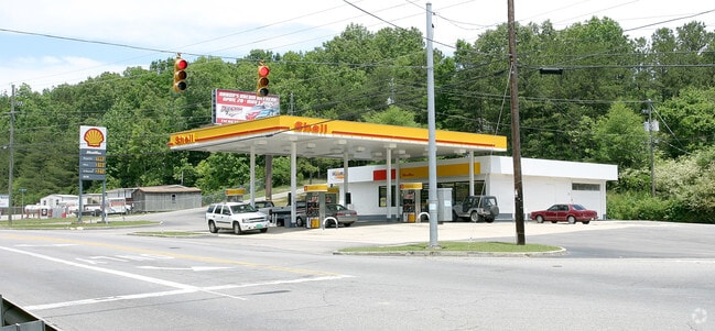
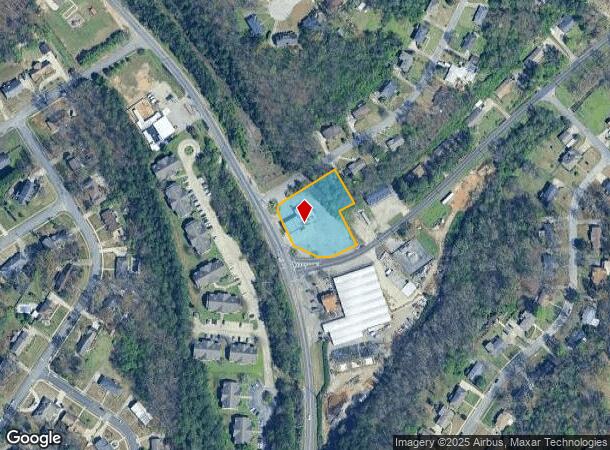
Property Record
2101 Carson Rd, Birmingham, AL 35215

NEARBY LISTINGS FOR SALE OR LEASE
Property Detail
2101 Carson Rd
13-00-13-3-003-062.000
BEG NW COR LOT 8-REDSTONE LAND & DEV COS 10TH SECT PB 81 PG 8 TH SW 206 S ALONG E R/W 5TH WAY N W SLY 38 S ALONG A CURVE TO N E R/W CARSON RD SE 103 S ALONG SD R/W SELY 102 FT S TO NW R/W SUN VALLEY RD NELY 138 S ALONG SD R/W NW 122 S NE 54 S NW 125
Storebuilding
Jefferson
X
Alabama
01073C0239H
8
2023
1.09 AC
2024
Fultondale
011804
Birmingham
2,530 SF
Birmingham-Hoover, AL
DEMOGRAPHICS near 2101 Carson Rd
1 Mile
3 Mile
5 Mile
2024 Total Population
8,213
50,593
84,209
2029 Population
7,983
49,693
82,516
Pop Growth 2024-2029
(2.80%)
(1.78%)
(2.01%)
Average Age
37
36
38
2024 Total Households
3,042
18,903
32,125
HH Growth 2024-2029
(2.93%)
(1.82%)
(2.06%)
Median Household Inc
$43,515
$44,897
$49,908
Avg Household Size
2.60
2.60
2.50
2024 Avg HH Vehicles
2.00
2.00
2.00
Median Home Value
$142,994
$141,094
$149,913
Median Year Built
1972
1974
1975
Nearby Places
Map Layers
Map Styles
 Street
 Aerial
- Restaurants
- Banks
- Shops
- Fitness
- Groceries
PUBLIC TRANSPORTATION
AIRPORT
Birmingham-Shuttlesworth International
DRIVE
WALK
Distance
Birmingham-Shuttlesworth International
19 min
10.2 mi
Freight Ports
Port of Mobile
DRIVE
WALK
Distance
Port of Mobile
300 min
271.0 mi
Nearby Properties
Address
Land Use
TOTAL SIZE
Lot Size
Zoning
Address
Land Use
TOTAL SIZE
Lot Size
Zoning
725,840 SF
89 AC
CM2
Address
Land Use
TOTAL SIZE
Lot Size
Zoning
150,160 SF
12 AC
INST
Address
Land Use
TOTAL SIZE
Lot Size
Zoning
284,402 SF
22.50 AC
I4
Address
Land Use
TOTAL SIZE
Lot Size
Zoning
1 SF
7.08 AC
CB2
Address
Land Use
TOTAL SIZE
Lot Size
Zoning
207,383 SF
17 AC
CR5
Address
Land Use
TOTAL SIZE
Lot Size
Zoning
623,200 SF
50 AC
CM2
Address
Land Use
TOTAL SIZE
Lot Size
Zoning
218,922 SF
21 AC
CR5
Address
Land Use
TOTAL SIZE
Lot Size
Zoning
112,806 SF
2.04 AC
R2
Address
Land Use
TOTAL SIZE
Lot Size
Zoning
412,320 SF
16.50 AC
I2
Address
Land Use
TOTAL SIZE
Lot Size
Zoning
192,596 SF
13.79 AC
CR5
Address
Land Use
TOTAL SIZE
Lot Size
Zoning
147,200 SF
7.93 AC
CR5
Address
Land Use
TOTAL SIZE
Lot Size
Zoning
118,522 SF
7.80 AC
I4
Address
Land Use
TOTAL SIZE
Lot Size
Zoning
531,808 SF
23.96 AC
I4&A
Address
Land Use
TOTAL SIZE
Lot Size
Zoning
92,560 SF
15.36 AC
I4
Address
Land Use
TOTAL SIZE
Lot Size
Zoning
148,245 SF
9.30 AC
CR5
Address
Land Use
TOTAL SIZE
Lot Size
Zoning
502,302 SF
24.61 AC
I4&A
Address
Land Use
TOTAL SIZE
Lot Size
Zoning
115,490 SF
3.88 AC
R2
Address
Land Use
TOTAL SIZE
Lot Size
Zoning
95,172 SF
6.40 AC
R2
Address
Land Use
TOTAL SIZE
Lot Size
Zoning
125,252 SF
8.07 AC
R4
Address
Land Use
TOTAL SIZE
Lot Size
Zoning
116,759 SF
6.10 AC
CR5
Address
Land Use
TOTAL SIZE
Lot Size
Zoning
116,732 SF
4.06 AC
R-4
Address
Land Use
TOTAL SIZE
Lot Size
Zoning
163,790 SF
18 AC
I-4
Address
Land Use
TOTAL SIZE
Lot Size
Zoning
179,464 SF
17.70 AC
M3
Address
Land Use
TOTAL SIZE
Lot Size
Zoning
86,434 SF
8.20 AC
QM1
Address
Land Use
TOTAL SIZE
Lot Size
Zoning
72,506 SF
4 AC
R2
Address
Land Use
TOTAL SIZE
Lot Size
Zoning
80,834 SF
7.13 AC
CR5
Address
Land Use
TOTAL SIZE
Lot Size
Zoning
340,000 SF
29 AC
I4
Address
Land Use
TOTAL SIZE
Lot Size
Zoning
26,169 SF
71 AC
R2
Address
Land Use
TOTAL SIZE
Lot Size
Zoning
109,878 SF
10 AC
C1
The World's #1 Commercial Real Estate Marketplace
Connect with us
© 2025 CoStar Group
The information above has been obtained from sources believed reliable. While we do not doubt its accuracy we have not verified it and make no guarantee, warranty or representation about it. It is your responsibility to independently confirm its accuracy and completeness. Any projections, opinions, assumptions, or estimates used are for example only and do not represent the current or future performance of the property. The value of this transaction to you depends on tax and other factors which should be evaluated by your tax, financial, and legal advisors. You and your advisors should conduct a careful, independent investigation of the property to determine to your satisfaction the suitability of the property for your needs.