Property Record
2101 E Churchville Rd, Bel Air, MD 21015


Current Lease Availabilities
NEARBY LISTINGS FOR SALE OR LEASE
-
-
View all Bel Air listings for lease on LoopNet.com
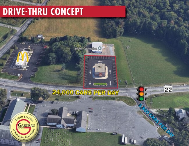
Property Detail
2101 E Churchville Rd
03-065634
Fulford
Commercialnec
1.22 ACRES 2101 E CHURCHVILLE ROAD FULFORD
X
Harford
24025C0166E
Maryland
2025
1.22 AC
2025
Outlying Harford County
303700
Baltimore
1,908 SF
Baltimore-Columbia-Towson, MD
DEMOGRAPHICS near 2101 E Churchville Rd
1 Mile
3 Mile
5 Mile
2024 Total Population
1,557
29,637
82,612
2029 Population
1,601
30,428
84,864
Pop Growth 2024-2029
+ 2.83%
+ 2.67%
+ 2.73%
Average Age
43
41
42
2024 Total Households
537
10,772
30,856
HH Growth 2024-2029
+ 2.79%
+ 2.78%
+ 2.80%
Median Household Inc
$122,856
$116,966
$108,789
Avg Household Size
2.80
2.70
2.60
2024 Avg HH Vehicles
2.00
2.00
2.00
Median Home Value
$388,607
$380,665
$369,977
Median Year Built
1982
1986
1986
Nearby Places
Map Layers
Map Styles
 Street
 Aerial
- Restaurants
- Banks
- Shops
- Fitness
- Groceries
PUBLIC TRANSPORTATION
COMMUTER RAIL
Aberdeen (Penn Line - Maryland Area Regional Commuter Trains (The MARC))
DRIVE
WALK
Distance
Aberdeen (Penn Line - Maryland Area Regional Commuter Trains (The MARC))
15 min
9.3 mi
AIRPORT
Baltimore/Washington International Thurgood Marshall
DRIVE
WALK
Distance
Baltimore/Washington International Thurgood Marshall
60 min
41.3 mi
Freight Ports
Port Newark Container Terminal
DRIVE
WALK
Distance
Port Newark Container Terminal
40 min
25.8 mi
Nearby Properties
Address
Land Use
TOTAL SIZE
Lot Size
Zoning
Address
Land Use
TOTAL SIZE
Lot Size
Zoning
22,578 SF
202.79 AC
AG
Address
Land Use
TOTAL SIZE
Lot Size
Zoning
5,674 SF
288 AC
R4
Address
Land Use
TOTAL SIZE
Lot Size
Zoning
161,723 SF
72.26 AC
R1
Address
Land Use
TOTAL SIZE
Lot Size
Zoning
228 AC
COS
Address
Land Use
TOTAL SIZE
Lot Size
Zoning
55,164 SF
16.22 AC
B2
Address
Land Use
TOTAL SIZE
Lot Size
Zoning
13.02 AC
R3
Address
Land Use
TOTAL SIZE
Lot Size
Zoning
80.33 AC
AG
Address
Land Use
TOTAL SIZE
Lot Size
Zoning
229,355 SF
59.83 AC
R2
Address
Land Use
TOTAL SIZE
Lot Size
Zoning
35.99 AC
R2
Address
Land Use
TOTAL SIZE
Lot Size
Zoning
37,540 SF
11.45 AC
B2
Address
Land Use
TOTAL SIZE
Lot Size
Zoning
69,800 SF
21.83 AC
B2
Address
Land Use
TOTAL SIZE
Lot Size
Zoning
25,744 SF
8.68 AC
AG
Address
Land Use
TOTAL SIZE
Lot Size
Zoning
42,072 SF
99.26 AC
AG
Address
Land Use
TOTAL SIZE
Lot Size
Zoning
12,900 SF
19.24 AC
AG
Address
Land Use
TOTAL SIZE
Lot Size
Zoning
25,434 SF
180.18 AC
AG
Address
Land Use
TOTAL SIZE
Lot Size
Zoning
15,072 SF
12.27 AC
AG
Address
Land Use
TOTAL SIZE
Lot Size
Zoning
5,785 SF
3.57 AC
B2
Address
Land Use
TOTAL SIZE
Lot Size
Zoning
12,449 SF
0.92 AC
B2
Address
Land Use
TOTAL SIZE
Lot Size
Zoning
47,538 SF
6.46 AC
VR
Address
Land Use
TOTAL SIZE
Lot Size
Zoning
37,027 SF
5.42 AC
R1
Address
Land Use
TOTAL SIZE
Lot Size
Zoning
23,740 SF
88.04 AC
AG
Address
Land Use
TOTAL SIZE
Lot Size
Zoning
10,113 SF
3.45 AC
B2 R3
Address
Land Use
TOTAL SIZE
Lot Size
Zoning
12.77 AC
R2
Address
Land Use
TOTAL SIZE
Lot Size
Zoning
7,318 SF
10.31 AC
B3
Address
Land Use
TOTAL SIZE
Lot Size
Zoning
23,534 SF
30.91 AC
AG
Address
Land Use
TOTAL SIZE
Lot Size
Zoning
7,040 SF
0.96 AC
B2
Address
Land Use
TOTAL SIZE
Lot Size
Zoning
4,668 SF
44.49 AC
R1
Address
Land Use
TOTAL SIZE
Lot Size
Zoning
21,318 SF
1.96 AC
RO
Address
Land Use
TOTAL SIZE
Lot Size
Zoning
17,600 SF
2.21 AC
B2
Address
Land Use
TOTAL SIZE
Lot Size
Zoning
16,865 SF
2.42 AC
B2
The World's #1 Commercial Real Estate Marketplace
Connect with us
© 2025 CoStar Group
The information above has been obtained from sources believed reliable. While we do not doubt its accuracy we have not verified it and make no guarantee, warranty or representation about it. It is your responsibility to independently confirm its accuracy and completeness. Any projections, opinions, assumptions, or estimates used are for example only and do not represent the current or future performance of the property. The value of this transaction to you depends on tax and other factors which should be evaluated by your tax, financial, and legal advisors. You and your advisors should conduct a careful, independent investigation of the property to determine to your satisfaction the suitability of the property for your needs.