Property Record
2101 Kennerly Rd, Irmo, SC 29063
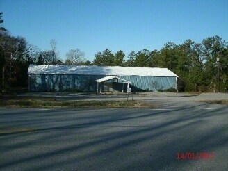

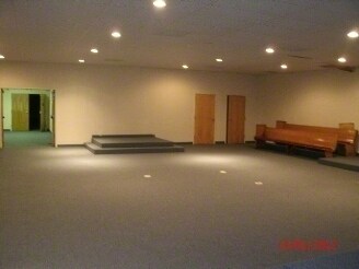
Property Detail
2101 Kennerly Rd
04200-06-91
LODGE 39 #SU #PR
Commercialnec
Richland
RU
South Carolina
B and X Area of moderate flood hazard, usually the area between the limits of the 100-year and 500-year floods.
3.38 AC
2024
Dutch Fork/Irmo
2023
Columbia
010308
Columbia, SC
5,523 SF
NEARBY LISTINGS FOR SALE OR LEASE
-
-
View all Irmo listings for sale on LoopNet.com
DEMOGRAPHICS near 2101 Kennerly Rd
1 mile
3 mile
5 mile
2025 Total Population
1,811
16,621
49,259
2030 Population
1,843
17,037
50,532
Pop Growth 2025-2030
+ 1.77%
+ 2.50%
+ 2.58%
Average Age
39
39
40
2025 Total Households
623
6,198
19,456
HH Growth 2025-2030
+ 1.77%
+ 2.58%
+ 2.70%
Median Household Inc
$106,925
$96,201
$84,002
Avg Household Size
2.80
2.70
2.50
2025 Avg HH Vehicles
3.00
2.00
2.00
Median Home Value
$365,929
$266,324
$261,253
Median Year Built
2002
1997
1993
Nearby Places
Map Layers
Map Styles
 Street
 Aerial
Transit
 Traffic
 Biking
Places
Listings with unknown addresses are not visible on the map
- Restaurants
- Banks
- Shops
- Fitness
- Groceries
PUBLIC TRANSPORTATION
AIRPORT
Columbia Metro
Drive
Walk
Distance
Columbia Metro
42 min
20.1 mi
Nearby Properties
Address
Land Use
TOTAL SIZE
Lot Size
Zoning
Address
Land Use
TOTAL SIZE
Lot Size
Zoning
153,210 SF
31.78 AC
LM
Address
Land Use
TOTAL SIZE
Lot Size
Zoning
75,358 SF
13.84 AC
M-1
Address
Land Use
TOTAL SIZE
Lot Size
Zoning
8,358 SF
9.12 AC
CG
Address
Land Use
TOTAL SIZE
Lot Size
Zoning
85,201 SF
48.22 AC
CG
Address
Land Use
TOTAL SIZE
Lot Size
Zoning
56,958 SF
6.21 AC
CG
Address
Land Use
TOTAL SIZE
Lot Size
Zoning
14,370 SF
6.84 AC
RU
Address
Land Use
TOTAL SIZE
Lot Size
Zoning
10 AC
PDD
Address
Land Use
TOTAL SIZE
Lot Size
Zoning
15,750 SF
5.83 AC
PDD
Address
Land Use
TOTAL SIZE
Lot Size
Zoning
16,856 SF
2.78 AC
M-1
Address
Land Use
TOTAL SIZE
Lot Size
Zoning
6,208 SF
3.18 AC
GC
Address
Land Use
TOTAL SIZE
Lot Size
Zoning
8,112 SF
2.43 AC
GC
Address
Land Use
TOTAL SIZE
Lot Size
Zoning
7,692 SF
18.09 AC
PDD
Address
Land Use
TOTAL SIZE
Lot Size
Zoning
10,982 SF
7.09 AC
GC
Address
Land Use
TOTAL SIZE
Lot Size
Zoning
9,100 SF
5.30 AC
GC
Address
Land Use
TOTAL SIZE
Lot Size
Zoning
9,841 SF
1.44 AC
CG
Address
Land Use
TOTAL SIZE
Lot Size
Zoning
8,242 SF
1.89 AC
M-1
Address
Land Use
TOTAL SIZE
Lot Size
Zoning
9,362 SF
2.69 AC
GC
Address
Land Use
TOTAL SIZE
Lot Size
Zoning
8,454 SF
1.01 AC
RU
Address
Land Use
TOTAL SIZE
Lot Size
Zoning
14,026 SF
1.64 AC
GC
Address
Land Use
TOTAL SIZE
Lot Size
Zoning
1,500 SF
1.99 AC
CG
Address
Land Use
TOTAL SIZE
Lot Size
Zoning
36,082 SF
4.29 AC
M-1
Address
Land Use
TOTAL SIZE
Lot Size
Zoning
1,843 SF
2.54 AC
GC
Address
Land Use
TOTAL SIZE
Lot Size
Zoning
14,976 SF
2.03 AC
RU
Address
Land Use
TOTAL SIZE
Lot Size
Zoning
30.14 AC
RU
Address
Land Use
TOTAL SIZE
Lot Size
Zoning
3,861 SF
1.46 AC
GC
Address
Land Use
TOTAL SIZE
Lot Size
Zoning
7,488 SF
3.60 AC
M-1
Address
Land Use
TOTAL SIZE
Lot Size
Zoning
2,207 SF
10.25 AC
RU
Address
Land Use
TOTAL SIZE
Lot Size
Zoning
10,515 SF
1.92 AC
RU
Address
Land Use
TOTAL SIZE
Lot Size
Zoning
6,650 SF
1.24 AC
GC
Address
Land Use
TOTAL SIZE
Lot Size
Zoning
8,627 SF
3.16 AC
RU
The World's #1 Commercial Real Estate Marketplace
Connect with us
© 2026 CoStar Group
The information above has been obtained from sources believed reliable. While we do not doubt its accuracy we have not verified it and make no guarantee, warranty or representation about it. It is your responsibility to independently confirm its accuracy and completeness. Any projections, opinions, assumptions, or estimates used are for example only and do not represent the current or future performance of the property. The value of this transaction to you depends on tax and other factors which should be evaluated by your tax, financial, and legal advisors. You and your advisors should conduct a careful, independent investigation of the property to determine to your satisfaction the suitability of the property for your needs.