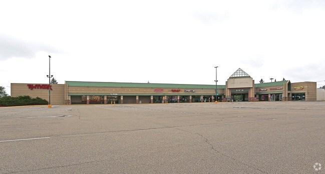
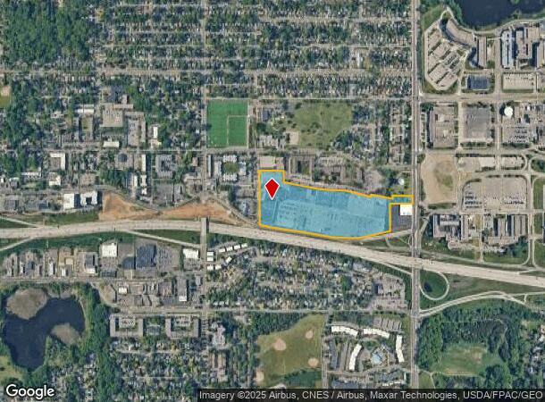
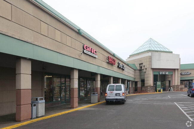
Property Record
2101 Old Hudson Rd, Saint Paul, MN 55119
NEARBY LISTINGS FOR SALE OR LEASE
Property Detail
2101 Old Hudson Rd
Minneapolis-St. Paul-Bloomington, MN-WI
Registered Land Survey 200
35-29-22-44-0054
REGISTERED LAND SURVEY 200 SUBJ TO HWY & EMSTS; PART OF TRACTS I,K N ...A,C,D,E,F,G,J, L,M, & TRACT O
Regionalshoppingcenterormallwithanchorstore
Ramsey
X
Minnesota
27037C0050E
tract
2024
21.92 AC
2025
Woodbury
034702
Minneapolis/St Paul
222,184 SF
DEMOGRAPHICS near 2101 Old Hudson Rd
1 Mile
3 Mile
5 Mile
2024 Total Population
14,937
104,967
268,580
2029 Population
14,547
103,356
268,546
Pop Growth 2024-2029
(2.61%)
(1.53%)
(0.01%)
Average Age
35
36
37
2024 Total Households
5,505
36,586
100,814
HH Growth 2024-2029
(2.60%)
(1.35%)
+ 0.24%
Median Household Inc
$56,117
$62,896
$68,743
Avg Household Size
2.50
2.70
2.50
2024 Avg HH Vehicles
2.00
2.00
2.00
Median Home Value
$215,944
$227,410
$258,109
Median Year Built
1968
1965
1970
Nearby Places
Map Layers
Map Styles
 Street
 Aerial
- Restaurants
- Banks
- Shops
- Fitness
- Groceries
PUBLIC TRANSPORTATION
COMMUTER RAIL
DRIVE
WALK
Distance
8 min
4.8 mi
AIRPORT
Minneapolis-St Paul International/Wold-Chamberlain
DRIVE
WALK
Distance
Minneapolis-St Paul International/Wold-Chamberlain
22 min
13.9 mi
SALE & LEASE HISTORY
LISTING DATE
SALE/LEASE

Sep 25, 2016
For Lease
Nearby Properties
Address
Land Use
TOTAL SIZE
Lot Size
Zoning
Address
Land Use
TOTAL SIZE
Lot Size
Zoning
267,948 SF
372.92 AC
Address
Land Use
TOTAL SIZE
Lot Size
Zoning
114,777 SF
22.45 AC
Address
Land Use
TOTAL SIZE
Lot Size
Zoning
270,348 SF
35.96 AC
Address
Land Use
TOTAL SIZE
Lot Size
Zoning
127,888 SF
141.04 AC
Address
Land Use
TOTAL SIZE
Lot Size
Zoning
460,439 SF
25.26 AC
Address
Land Use
TOTAL SIZE
Lot Size
Zoning
29.55 AC
Address
Land Use
TOTAL SIZE
Lot Size
Zoning
32,159 SF
448.26 AC
Address
Land Use
TOTAL SIZE
Lot Size
Zoning
3,080 SF
9.37 AC
Address
Land Use
TOTAL SIZE
Lot Size
Zoning
81,006 SF
12.05 AC
Address
Land Use
TOTAL SIZE
Lot Size
Zoning
147,199 SF
32.47 AC
Address
Land Use
TOTAL SIZE
Lot Size
Zoning
53,851 SF
22.74 AC
Address
Land Use
TOTAL SIZE
Lot Size
Zoning
311,332 SF
36.34 AC
Address
Land Use
TOTAL SIZE
Lot Size
Zoning
181.88 AC
Address
Land Use
TOTAL SIZE
Lot Size
Zoning
246,000 SF
31.03 AC
Address
Land Use
TOTAL SIZE
Lot Size
Zoning
9.90 AC
Address
Land Use
TOTAL SIZE
Lot Size
Zoning
41,868 SF
6.69 AC
Address
Land Use
TOTAL SIZE
Lot Size
Zoning
297,750 SF
11.54 AC
Address
Land Use
TOTAL SIZE
Lot Size
Zoning
262,872 SF
14.22 AC
Address
Land Use
TOTAL SIZE
Lot Size
Zoning
13.43 AC
Address
Land Use
TOTAL SIZE
Lot Size
Zoning
41,201 SF
9.55 AC
Address
Land Use
TOTAL SIZE
Lot Size
Zoning
256,440 SF
27.44 AC
Address
Land Use
TOTAL SIZE
Lot Size
Zoning
221,625 SF
3.94 AC
Address
Land Use
TOTAL SIZE
Lot Size
Zoning
371,200 SF
8.99 AC
Address
Land Use
TOTAL SIZE
Lot Size
Zoning
Address
Land Use
TOTAL SIZE
Lot Size
Zoning
49,691 SF
10.94 AC
Address
Land Use
TOTAL SIZE
Lot Size
Zoning
Address
Land Use
TOTAL SIZE
Lot Size
Zoning
163,561 SF
41.09 AC
Address
Land Use
TOTAL SIZE
Lot Size
Zoning
92,091 SF
2.78 AC
Address
Land Use
TOTAL SIZE
Lot Size
Zoning
78,278 SF
4.08 AC
Address
Land Use
TOTAL SIZE
Lot Size
Zoning
188,160 SF
7.53 AC
The World's #1 Commercial Real Estate Marketplace
Connect with us
© 2026 CoStar Group
The information above has been obtained from sources believed reliable. While we do not doubt its accuracy we have not verified it and make no guarantee, warranty or representation about it. It is your responsibility to independently confirm its accuracy and completeness. Any projections, opinions, assumptions, or estimates used are for example only and do not represent the current or future performance of the property. The value of this transaction to you depends on tax and other factors which should be evaluated by your tax, financial, and legal advisors. You and your advisors should conduct a careful, independent investigation of the property to determine to your satisfaction the suitability of the property for your needs.