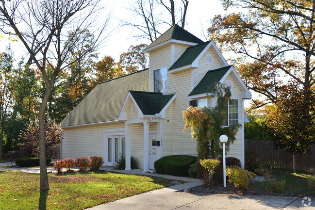
Property Record
2101 Republican Cir, Fairborn, OH 45324


NEARBY LISTINGS FOR SALE OR LEASE
-
-
View all Fairborn listings for sale on LoopNet.com
Property Detail
2101 Republican Cir
Dayton, OH
Oak Tree Village
A02-0002-0012-0-0145-00
OAK TREE VILLAGE LOT 7122 3.225AC DAYTON Y S RD
Apartmenthouse5plusunits
Greene
X
Ohio
39057C0020E
7122
2024
3.23 AC
2024
Fairborn/AFB
200103
Cincinnati/Dayton
2,942 SF
DEMOGRAPHICS near 2101 Republican Cir
1 Mile
3 Mile
5 Mile
2024 Total Population
9,076
45,464
79,240
2029 Population
9,346
47,127
81,550
Pop Growth 2024-2029
+ 2.97%
+ 3.66%
+ 2.92%
Average Age
41
38
39
2024 Total Households
4,203
19,803
33,115
HH Growth 2024-2029
+ 3.02%
+ 3.81%
+ 3.05%
Median Household Inc
$63,798
$64,477
$76,468
Avg Household Size
2.10
2.20
2.30
2024 Avg HH Vehicles
2.00
2.00
2.00
Median Home Value
$153,493
$176,260
$203,423
Median Year Built
1974
1980
1978
Nearby Places
Map Layers
Map Styles
 Street
 Aerial
- Restaurants
- Banks
- Shops
- Fitness
- Groceries
PUBLIC TRANSPORTATION
AIRPORT
James M Cox Dayton International
DRIVE
WALK
Distance
James M Cox Dayton International
31 min
22.3 mi
Nearby Properties
Address
Land Use
TOTAL SIZE
Lot Size
Zoning
Address
Land Use
TOTAL SIZE
Lot Size
Zoning
132,168 SF
128 AC
PD1
Address
Land Use
TOTAL SIZE
Lot Size
Zoning
259,051 SF
13.39 AC
Address
Land Use
TOTAL SIZE
Lot Size
Zoning
289,136 SF
69.81 AC
R2
Address
Land Use
TOTAL SIZE
Lot Size
Zoning
552,803 SF
29.77 AC
CPUD882
Address
Land Use
TOTAL SIZE
Lot Size
Zoning
33,504 SF
14 AC
Address
Land Use
TOTAL SIZE
Lot Size
Zoning
7,087 SF
31.93 AC
MX-PUD 93-
Address
Land Use
TOTAL SIZE
Lot Size
Zoning
107,570 SF
8.45 AC
Address
Land Use
TOTAL SIZE
Lot Size
Zoning
49,316 SF
30.39 AC
CPUD933
Address
Land Use
TOTAL SIZE
Lot Size
Zoning
3,243 SF
22.88 AC
R-PUD 97-3
Address
Land Use
TOTAL SIZE
Lot Size
Zoning
136,572 SF
5.59 AC
CPUD055
Address
Land Use
TOTAL SIZE
Lot Size
Zoning
101,768 SF
22.02 AC
B1
Address
Land Use
TOTAL SIZE
Lot Size
Zoning
47,424 SF
22.77 AC
RPUD917
Address
Land Use
TOTAL SIZE
Lot Size
Zoning
111,938 SF
10.03 AC
Address
Land Use
TOTAL SIZE
Lot Size
Zoning
27,740 SF
11.16 AC
MXPUD93
Address
Land Use
TOTAL SIZE
Lot Size
Zoning
32,852 SF
18.80 AC
C-PUD 94-4
Address
Land Use
TOTAL SIZE
Lot Size
Zoning
45,522 SF
10.22 AC
Address
Land Use
TOTAL SIZE
Lot Size
Zoning
3,038 SF
13.49 AC
RPUD936
Address
Land Use
TOTAL SIZE
Lot Size
Zoning
18,576 SF
11.66 AC
Address
Land Use
TOTAL SIZE
Lot Size
Zoning
121,392 SF
12.47 AC
Address
Land Use
TOTAL SIZE
Lot Size
Zoning
76,038 SF
12.59 AC
CPUD971
Address
Land Use
TOTAL SIZE
Lot Size
Zoning
57,816 SF
9.15 AC
PD1
Address
Land Use
TOTAL SIZE
Lot Size
Zoning
143,457 SF
19.42 AC
CPUD918
Address
Land Use
TOTAL SIZE
Lot Size
Zoning
73,040 SF
12.99 AC
RPUD901
Address
Land Use
TOTAL SIZE
Lot Size
Zoning
594,070 SF
43.95 AC
AG
Address
Land Use
TOTAL SIZE
Lot Size
Zoning
45,204 SF
14.92 AC
PD1
Address
Land Use
TOTAL SIZE
Lot Size
Zoning
75,168 SF
2.73 AC
Address
Land Use
TOTAL SIZE
Lot Size
Zoning
46,802 SF
25.30 AC
R3
Address
Land Use
TOTAL SIZE
Lot Size
Zoning
81,978 SF
3.64 AC
CPUD055
Address
Land Use
TOTAL SIZE
Lot Size
Zoning
1,630 SF
8.41 AC
MXPUD93
Address
Land Use
TOTAL SIZE
Lot Size
Zoning
163,780 SF
36.93 AC
PARK
The World's #1 Commercial Real Estate Marketplace
Connect with us
© 2026 CoStar Group
The information above has been obtained from sources believed reliable. While we do not doubt its accuracy we have not verified it and make no guarantee, warranty or representation about it. It is your responsibility to independently confirm its accuracy and completeness. Any projections, opinions, assumptions, or estimates used are for example only and do not represent the current or future performance of the property. The value of this transaction to you depends on tax and other factors which should be evaluated by your tax, financial, and legal advisors. You and your advisors should conduct a careful, independent investigation of the property to determine to your satisfaction the suitability of the property for your needs.