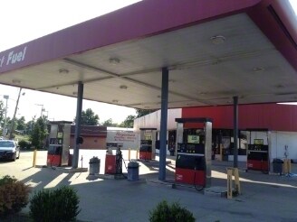
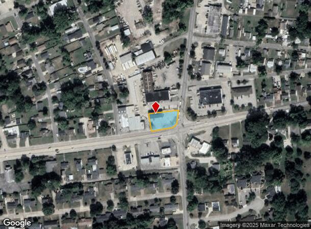
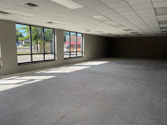
Property Record
2101 W Parrish Ave, Owensboro, KY 42301
NEARBY LISTINGS FOR SALE OR LEASE
Property Detail
2101 W Parrish Ave
005-12-05-001-00-000
Smiths Addition
Commercialnec
5-12-5-12101 PARRISH AVE W153 X 78
X
Daviess
21059C0119E
Kentucky
2025
0.27 AC
2025
Kentucky West Area
000600
Other Market Areas
3,028 SF
Owensboro, KY
DEMOGRAPHICS near 2101 W Parrish Ave
1 Mile
3 Mile
5 Mile
2024 Total Population
12,792
55,486
71,638
2029 Population
12,889
55,625
71,821
Pop Growth 2024-2029
+ 0.76%
+ 0.25%
+ 0.26%
Average Age
41
40
40
2024 Total Households
5,329
23,340
29,454
HH Growth 2024-2029
+ 0.84%
+ 0.28%
+ 0.28%
Median Household Inc
$43,278
$47,873
$54,836
Avg Household Size
2.30
2.30
2.30
2024 Avg HH Vehicles
2.00
2.00
2.00
Median Home Value
$135,903
$138,812
$159,584
Median Year Built
1961
1969
1973
Nearby Places
Map Layers
Map Styles
 Street
 Aerial
- Restaurants
- Banks
- Shops
- Fitness
- Groceries
PUBLIC TRANSPORTATION
AIRPORT
Evansville Regional
DRIVE
WALK
Distance
Evansville Regional
57 min
40.9 mi
Freight Ports
Port of Toledo
DRIVE
WALK
Distance
Port of Toledo
475 min
412.6 mi
SALE & LEASE HISTORY
LISTING DATE
SALE/LEASE

Sep 23, 2016
For Sale
Oct 03, 2022
For Sale
Nearby Properties
Address
Land Use
TOTAL SIZE
Lot Size
Zoning
Address
Land Use
TOTAL SIZE
Lot Size
Zoning
169,482 SF
10.21 AC
Address
Land Use
TOTAL SIZE
Lot Size
Zoning
3,610 SF
1.23 AC
Address
Land Use
TOTAL SIZE
Lot Size
Zoning
450,235 SF
24.61 AC
Address
Land Use
TOTAL SIZE
Lot Size
Zoning
184,854 SF
9.46 AC
Address
Land Use
TOTAL SIZE
Lot Size
Zoning
198,394 SF
49.52 AC
Address
Land Use
TOTAL SIZE
Lot Size
Zoning
371,705 SF
57.02 AC
Address
Land Use
TOTAL SIZE
Lot Size
Zoning
88,745 SF
2.62 AC
Address
Land Use
TOTAL SIZE
Lot Size
Zoning
454,200 SF
44.55 AC
Address
Land Use
TOTAL SIZE
Lot Size
Zoning
424,078 SF
43.02 AC
Address
Land Use
TOTAL SIZE
Lot Size
Zoning
46,184 SF
1.99 AC
Address
Land Use
TOTAL SIZE
Lot Size
Zoning
215,840 SF
14 AC
Address
Land Use
TOTAL SIZE
Lot Size
Zoning
113,025 SF
2.10 AC
Address
Land Use
TOTAL SIZE
Lot Size
Zoning
187,364 SF
18.64 AC
Address
Land Use
TOTAL SIZE
Lot Size
Zoning
62,312 SF
0.88 AC
Address
Land Use
TOTAL SIZE
Lot Size
Zoning
29,600 SF
3.38 AC
Address
Land Use
TOTAL SIZE
Lot Size
Zoning
478,052 SF
26.50 AC
Address
Land Use
TOTAL SIZE
Lot Size
Zoning
165,207 SF
15.76 AC
Address
Land Use
TOTAL SIZE
Lot Size
Zoning
9,725 SF
22.36 AC
Address
Land Use
TOTAL SIZE
Lot Size
Zoning
215,439 SF
15.02 AC
Address
Land Use
TOTAL SIZE
Lot Size
Zoning
82,027 SF
2.40 AC
Address
Land Use
TOTAL SIZE
Lot Size
Zoning
38,052 SF
11.46 AC
Address
Land Use
TOTAL SIZE
Lot Size
Zoning
180 SF
122.13 AC
Address
Land Use
TOTAL SIZE
Lot Size
Zoning
53,280 SF
Address
Land Use
TOTAL SIZE
Lot Size
Zoning
326,232 SF
29.64 AC
Address
Land Use
TOTAL SIZE
Lot Size
Zoning
54,713 SF
20 AC
Address
Land Use
TOTAL SIZE
Lot Size
Zoning
280 SF
2.60 AC
Address
Land Use
TOTAL SIZE
Lot Size
Zoning
45,860 SF
13.88 AC
Address
Land Use
TOTAL SIZE
Lot Size
Zoning
69,884 SF
61.31 AC
Address
Land Use
TOTAL SIZE
Lot Size
Zoning
122,450 SF
7.63 AC
Address
Land Use
TOTAL SIZE
Lot Size
Zoning
193,067 SF
19.80 AC
The World's #1 Commercial Real Estate Marketplace
Connect with us
© 2025 CoStar Group
The information above has been obtained from sources believed reliable. While we do not doubt its accuracy we have not verified it and make no guarantee, warranty or representation about it. It is your responsibility to independently confirm its accuracy and completeness. Any projections, opinions, assumptions, or estimates used are for example only and do not represent the current or future performance of the property. The value of this transaction to you depends on tax and other factors which should be evaluated by your tax, financial, and legal advisors. You and your advisors should conduct a careful, independent investigation of the property to determine to your satisfaction the suitability of the property for your needs.