Property Record
2101 Winsted Rd, Torrington, CT 06790


Property Detail
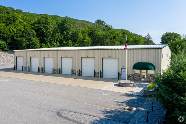
2101 Winsted Rd
10632
Nw Hills
Parkingstructure
Connecticut
I
4
2025
4.70 AC
2025
Rt 8/Winsted
310700
Hartford
15,400 SF
Torrington, CT
NEARBY LISTINGS FOR SALE OR LEASE
DEMOGRAPHICS near 2101 Winsted Rd
1 mile
3 mile
5 mile
2025 Total Population
936
14,501
43,927
2030 Population
944
14,657
44,191
Pop Growth 2025-2030
+ 0.85%
+ 1.08%
+ 0.60%
Average Age
46
45
44
2025 Total Households
442
6,198
19,020
HH Growth 2025-2030
+ 0.68%
+ 1.03%
+ 0.63%
Median Household Inc
$82,500
$82,005
$73,179
Avg Household Size
2.10
2.20
2.20
2025 Avg HH Vehicles
2.00
2.00
2.00
Median Home Value
$206,190
$228,836
$236,022
Median Year Built
1982
1973
1961
Nearby Places
Map Layers
Map Styles
 Street
 Aerial
Transit
 Traffic
 Biking
Places
Listings with unknown addresses are not visible on the map
- Restaurants
- Banks
- Shops
- Fitness
- Groceries
PUBLIC TRANSPORTATION
AIRPORT
Bradley International
Drive
Walk
Distance
Bradley International
58 min
29.1 mi
Freight Ports
Port of New Haven
Drive
Walk
Distance
Port of New Haven
68 min
48.1 mi
SALE & LEASE HISTORY
LISTING DATE
SALE/LEASE

Sep 04, 2019
For Sale
Nearby Properties
Address
Land Use
TOTAL SIZE
Lot Size
Zoning
Address
Land Use
TOTAL SIZE
Lot Size
Zoning
171,271 SF
26 AC
R-WP
Address
Land Use
TOTAL SIZE
Lot Size
Zoning
10.80 AC
R10S
Address
Land Use
TOTAL SIZE
Lot Size
Zoning
128,711 SF
18.50 AC
LB
Address
Land Use
TOTAL SIZE
Lot Size
Zoning
137,045 SF
14.49 AC
LB
Address
Land Use
TOTAL SIZE
Lot Size
Zoning
13,576 SF
12.80 AC
R10
Address
Land Use
TOTAL SIZE
Lot Size
Zoning
95,978 SF
CIR
Address
Land Use
TOTAL SIZE
Lot Size
Zoning
7.71 AC
LB
Address
Land Use
TOTAL SIZE
Lot Size
Zoning
200,000 SF
32.82 AC
IP
Address
Land Use
TOTAL SIZE
Lot Size
Zoning
56,699 SF
11.41 AC
LB
Address
Land Use
TOTAL SIZE
Lot Size
Zoning
63,735 SF
3.32 AC
CIR
Address
Land Use
TOTAL SIZE
Lot Size
Zoning
25,393 SF
12.60 AC
R10S
Address
Land Use
TOTAL SIZE
Lot Size
Zoning
93,608 SF
25.40 AC
B
Address
Land Use
TOTAL SIZE
Lot Size
Zoning
15.80 AC
R6
Address
Land Use
TOTAL SIZE
Lot Size
Zoning
30.48 AC
IP
Address
Land Use
TOTAL SIZE
Lot Size
Zoning
5.41 AC
IP
Address
Land Use
TOTAL SIZE
Lot Size
Zoning
68,160 SF
2.31 AC
LB
Address
Land Use
TOTAL SIZE
Lot Size
Zoning
5.17 AC
LB
Address
Land Use
TOTAL SIZE
Lot Size
Zoning
5.30 AC
R6
Address
Land Use
TOTAL SIZE
Lot Size
Zoning
9.39 AC
LB
Address
Land Use
TOTAL SIZE
Lot Size
Zoning
74,041 SF
7.60 AC
R15S
Address
Land Use
TOTAL SIZE
Lot Size
Zoning
36.55 AC
CIR
Address
Land Use
TOTAL SIZE
Lot Size
Zoning
132,962 SF
7.30 AC
IP
Address
Land Use
TOTAL SIZE
Lot Size
Zoning
59,670 SF
4.31 AC
R6
Address
Land Use
TOTAL SIZE
Lot Size
Zoning
35 AC
R15S
Address
Land Use
TOTAL SIZE
Lot Size
Zoning
93,750 SF
9.19 AC
IP
Address
Land Use
TOTAL SIZE
Lot Size
Zoning
129,282 SF
27.60 AC
I
Address
Land Use
TOTAL SIZE
Lot Size
Zoning
8.13 AC
LB
Address
Land Use
TOTAL SIZE
Lot Size
Zoning
90,039 SF
6.98 AC
IP
Address
Land Use
TOTAL SIZE
Lot Size
Zoning
81,365 SF
10.11 AC
IP
Address
Land Use
TOTAL SIZE
Lot Size
Zoning
193.61 AC
I
The World's #1 Commercial Real Estate Marketplace
Connect with us
© 2026 CoStar Group
The information above has been obtained from sources believed reliable. While we do not doubt its accuracy we have not verified it and make no guarantee, warranty or representation about it. It is your responsibility to independently confirm its accuracy and completeness. Any projections, opinions, assumptions, or estimates used are for example only and do not represent the current or future performance of the property. The value of this transaction to you depends on tax and other factors which should be evaluated by your tax, financial, and legal advisors. You and your advisors should conduct a careful, independent investigation of the property to determine to your satisfaction the suitability of the property for your needs.