Property Record
21014 Floyd St, Bucyrus, KS 66013
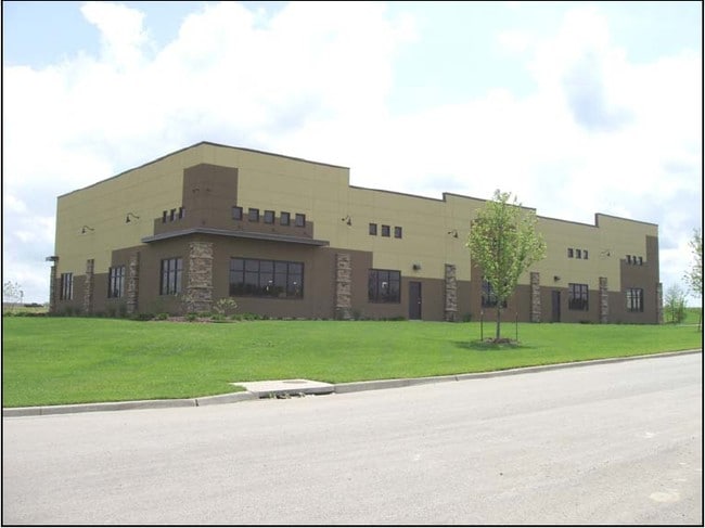

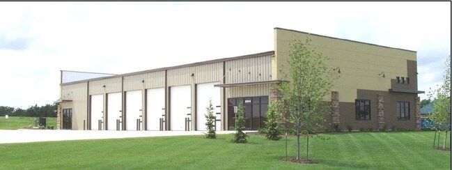
Property Detail
21014 Floyd St
1P26240000-0016
METCALF 211 LT 16 AU 368 5 16
Warehouse
Miami
PEC3
Kansas
B and X Area of moderate flood hazard, usually the area between the limits of the 100-year and 500-year floods.
16
2024
1.09 AC
2025
Metcalf/SE JoCo
053803
Kansas City
9,044 SF
Kansas City, MO-KS
NEARBY LISTINGS FOR SALE OR LEASE
-
-
View all Bucyrus listings for sale on LoopNet.com
DEMOGRAPHICS near 21014 Floyd St
1 mile
3 mile
5 mile
2025 Total Population
90
3,588
7,842
2030 Population
93
3,727
8,244
Pop Growth 2025-2030
+ 3.33%
+ 3.87%
+ 5.13%
Average Age
43
42
42
2025 Total Households
32
1,267
2,713
HH Growth 2025-2030
+ 3.13%
+ 3.95%
+ 5.12%
Median Household Inc
$131,250
$137,687
$153,151
Avg Household Size
2.70
2.80
2.90
2025 Avg HH Vehicles
3.00
3.00
3.00
Median Home Value
$499,999
$574,353
$664,837
Median Year Built
1983
1985
1992
Nearby Places
Map Layers
Map Styles
 Street
 Aerial
Layers
 Traffic
 Biking
Places
Listings with unknown addresses are not visible on the map
- Restaurants
- Banks
- Shops
- Fitness
- Groceries
SALE & LEASE HISTORY
LISTING DATE
SALE/LEASE

Sep 24, 2016
For Sale
Nearby Properties
Address
Land Use
TOTAL SIZE
Lot Size
Zoning
Address
Land Use
TOTAL SIZE
Lot Size
Zoning
71,610 SF
6.11 AC
RN1
Address
Land Use
TOTAL SIZE
Lot Size
Zoning
13,187 SF
3.12 AC
RUR
Address
Land Use
TOTAL SIZE
Lot Size
Zoning
24,252 SF
3.91 AC
RN1
Address
Land Use
TOTAL SIZE
Lot Size
Zoning
48,165 SF
5.79 AC
RUR
Address
Land Use
TOTAL SIZE
Lot Size
Zoning
12,112 SF
5.50 AC
RN1
Address
Land Use
TOTAL SIZE
Lot Size
Zoning
7,726 SF
4.63 AC
RURJ
Address
Land Use
TOTAL SIZE
Lot Size
Zoning
3,456 SF
78.05 AC
RURJ
Address
Land Use
TOTAL SIZE
Lot Size
Zoning
5,600 SF
6.73 AC
PEC3
Address
Land Use
TOTAL SIZE
Lot Size
Zoning
13,500 SF
2.23 AC
PEC3
Address
Land Use
TOTAL SIZE
Lot Size
Zoning
23,110 SF
9.94 AC
RUR
Address
Land Use
TOTAL SIZE
Lot Size
Zoning
11,568 SF
3.99 AC
RUR
Address
Land Use
TOTAL SIZE
Lot Size
Zoning
45.23 AC
RUR
Address
Land Use
TOTAL SIZE
Lot Size
Zoning
20,056 SF
11.64 AC
PRB1J
Address
Land Use
TOTAL SIZE
Lot Size
Zoning
9,800 SF
15.74 AC
PEC3
Address
Land Use
TOTAL SIZE
Lot Size
Zoning
16,108 SF
68.40 AC
RN2
Address
Land Use
TOTAL SIZE
Lot Size
Zoning
14,232 SF
12.26 AC
RN1
Address
Land Use
TOTAL SIZE
Lot Size
Zoning
22,504 SF
3.07 AC
RUR
Address
Land Use
TOTAL SIZE
Lot Size
Zoning
20,415 SF
4.55 AC
PRB1J
Address
Land Use
TOTAL SIZE
Lot Size
Zoning
20,606 SF
8.90 AC
PRB2
Address
Land Use
TOTAL SIZE
Lot Size
Zoning
23,230 SF
6.38 AC
PEC3
Address
Land Use
TOTAL SIZE
Lot Size
Zoning
11,736 SF
20.06 AC
RUR
Address
Land Use
TOTAL SIZE
Lot Size
Zoning
17,366 SF
52.91 AC
RUR
Address
Land Use
TOTAL SIZE
Lot Size
Zoning
8,816 SF
0.49 AC
PRB1A
Address
Land Use
TOTAL SIZE
Lot Size
Zoning
15,464 SF
1.99 AC
PRB2
Address
Land Use
TOTAL SIZE
Lot Size
Zoning
14,200 SF
3.76 AC
PRB2
Address
Land Use
TOTAL SIZE
Lot Size
Zoning
6,388 SF
9.64 AC
RUR
Address
Land Use
TOTAL SIZE
Lot Size
Zoning
6,000 SF
6.93 AC
PEC3
Address
Land Use
TOTAL SIZE
Lot Size
Zoning
9.52 AC
RUR
Address
Land Use
TOTAL SIZE
Lot Size
Zoning
8,496 SF
10 AC
RUR
The World's #1 Commercial Real Estate Marketplace
Connect with us
© 2026 CoStar Group
The information above has been obtained from sources believed reliable. While we do not doubt its accuracy we have not verified it and make no guarantee, warranty or representation about it. It is your responsibility to independently confirm its accuracy and completeness. Any projections, opinions, assumptions, or estimates used are for example only and do not represent the current or future performance of the property. The value of this transaction to you depends on tax and other factors which should be evaluated by your tax, financial, and legal advisors. You and your advisors should conduct a careful, independent investigation of the property to determine to your satisfaction the suitability of the property for your needs.