No Photo
Property Record
2102 E Market St, Nappanee, IN 46550

Save to a Folder
{{folder.Name}}
{{folder.ListingIds.length}} Properties
{{folder.ListingIds.length}} Property
Create a New Folder
Property Detail
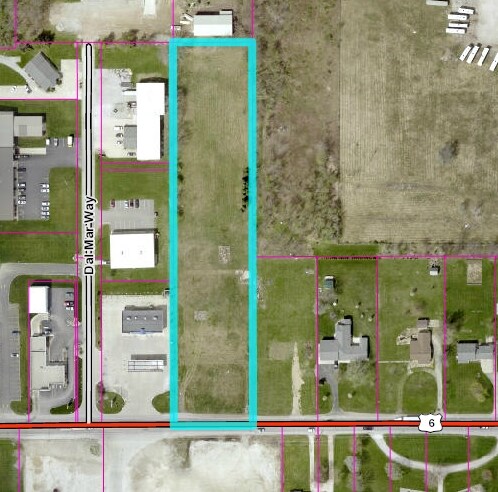
2102 E Market St
20-14-32-176-012.000-029
165X1370FT SW COR OF SE1/4 NW1/4 SEC 32 EX 2.08A EX .379A 2.541A
Warehouse
ELKHART
ZO01
Indiana
B and X Area of moderate flood hazard, usually the area between the limits of the 100-year and 500-year floods.
2.54 AC
2024
Outlying Elkhart County
2025
South Bend/Mishawaka
001200
Elkhart-Goshen, IN
12,150 SF
NEARBY LISTINGS FOR SALE OR LEASE
-
-
View all Nappanee listings for sale on LoopNet.com
DEMOGRAPHICS near 2102 E Market St
1 mile
3 mile
5 mile
2025 Total Population
1,942
9,912
12,517
2030 Population
1,938
9,922
12,453
Pop Growth 2025-2030
(0.21%)
+ 0.10%
(0.51%)
Average Age
39
37
36
2025 Total Households
741
3,569
4,347
HH Growth 2025-2030
(0.13%)
+ 0.20%
(0.37%)
Median Household Inc
$69,719
$71,074
$75,767
Avg Household Size
2.60
2.80
2.90
2025 Avg HH Vehicles
2.00
2.00
2.00
Median Home Value
$235,449
$238,704
$247,973
Median Year Built
1961
1978
1977
Nearby Places
Map Layers
Map Styles
 Street
 Aerial
Layers
 Traffic
 Biking
Places
Listings with unknown addresses are not visible on the map
- Restaurants
- Banks
- Shops
- Fitness
- Groceries
PUBLIC TRANSPORTATION
AIRPORT
South Bend International
Drive
Walk
Distance
South Bend International
61 min
36.8 mi
SALE & LEASE HISTORY
LISTING DATE
SALE/LEASE

Aug 29, 2017
For Sale
Nearby Properties
Address
Land Use
TOTAL SIZE
Lot Size
Zoning
Address
Land Use
TOTAL SIZE
Lot Size
Zoning
290,978 SF
47.73 AC
ZO01
Address
Land Use
TOTAL SIZE
Lot Size
Zoning
372,094 SF
23.08 AC
ZO01
Address
Land Use
TOTAL SIZE
Lot Size
Zoning
211,820 SF
21.29 AC
Address
Land Use
TOTAL SIZE
Lot Size
Zoning
163,465 SF
6.87 AC
ZO01
Address
Land Use
TOTAL SIZE
Lot Size
Zoning
124,904 SF
15.35 AC
ZO01
Address
Land Use
TOTAL SIZE
Lot Size
Zoning
162,000 SF
18.89 AC
ZO01
Address
Land Use
TOTAL SIZE
Lot Size
Zoning
75,700 SF
3.75 AC
ZO01
Address
Land Use
TOTAL SIZE
Lot Size
Zoning
192,708 SF
22.15 AC
ZO01
Address
Land Use
TOTAL SIZE
Lot Size
Zoning
169,475 SF
7.14 AC
ZO01
Address
Land Use
TOTAL SIZE
Lot Size
Zoning
107,535 SF
18.35 AC
ZO01
Address
Land Use
TOTAL SIZE
Lot Size
Zoning
184,031 SF
12.85 AC
ZO01
Address
Land Use
TOTAL SIZE
Lot Size
Zoning
214,408 SF
18.22 AC
ZO01
Address
Land Use
TOTAL SIZE
Lot Size
Zoning
168,159 SF
17.75 AC
ZO01
Address
Land Use
TOTAL SIZE
Lot Size
Zoning
163,840 SF
12.91 AC
ZO01
Address
Land Use
TOTAL SIZE
Lot Size
Zoning
101,160 SF
15.36 AC
ZO01
Address
Land Use
TOTAL SIZE
Lot Size
Zoning
170,623 SF
14.44 AC
ZO01
Address
Land Use
TOTAL SIZE
Lot Size
Zoning
126,560 SF
14.26 AC
ZO01
Address
Land Use
TOTAL SIZE
Lot Size
Zoning
51,584 SF
5.76 AC
ZO01
Address
Land Use
TOTAL SIZE
Lot Size
Zoning
17,120 SF
25.07 AC
Address
Land Use
TOTAL SIZE
Lot Size
Zoning
127,700 SF
13.08 AC
ZO01
Address
Land Use
TOTAL SIZE
Lot Size
Zoning
77,200 SF
5 AC
ZO01
Address
Land Use
TOTAL SIZE
Lot Size
Zoning
167,376 SF
10 AC
ZO01
Address
Land Use
TOTAL SIZE
Lot Size
Zoning
84,954 SF
6.47 AC
ZO01
Address
Land Use
TOTAL SIZE
Lot Size
Zoning
96,808 SF
6.88 AC
ZO01
Address
Land Use
TOTAL SIZE
Lot Size
Zoning
123,706 SF
9.27 AC
ZO01
Address
Land Use
TOTAL SIZE
Lot Size
Zoning
17,664 SF
6 AC
ZO01
Address
Land Use
TOTAL SIZE
Lot Size
Zoning
44,464 SF
3.54 AC
ZO01
Address
Land Use
TOTAL SIZE
Lot Size
Zoning
42,765 SF
3.49 AC
ZO01
Address
Land Use
TOTAL SIZE
Lot Size
Zoning
58,500 SF
6.53 AC
ZO01
Address
Land Use
TOTAL SIZE
Lot Size
Zoning
18,456 SF
18 AC
COMME
The World's #1 Commercial Real Estate Marketplace
Connect with us
© 2026 CoStar Group
The information above has been obtained from sources believed reliable. While we do not doubt its accuracy we have not verified it and make no guarantee, warranty or representation about it. It is your responsibility to independently confirm its accuracy and completeness. Any projections, opinions, assumptions, or estimates used are for example only and do not represent the current or future performance of the property. The value of this transaction to you depends on tax and other factors which should be evaluated by your tax, financial, and legal advisors. You and your advisors should conduct a careful, independent investigation of the property to determine to your satisfaction the suitability of the property for your needs.