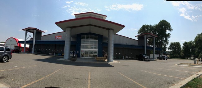
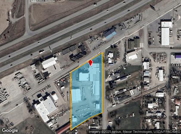
Property Record
2102 Old Hardin Rd, Billings, MT 59101

NEARBY LISTINGS FOR SALE OR LEASE
Property Detail
2102 Old Hardin Rd
Billings, MT
Widell Subd
03-1033-25-4-14-12-0000
WIDELL SUBD, S25, T01 N, R26 E, BLOCK 1, LOT 2 - 14, (24)
Commercialnec
Yellowstone
X
Montana
30111C1295E
2-14
2024
3.61 AC
2025
Billings
000800
Other Market Areas
39,574 SF
DEMOGRAPHICS near 2102 Old Hardin Rd
1 Mile
3 Mile
5 Mile
2024 Total Population
2,778
24,945
60,746
2029 Population
2,978
26,907
65,594
Pop Growth 2024-2029
+ 7.20%
+ 7.87%
+ 7.98%
Average Age
39
39
39
2024 Total Households
1,056
9,895
24,681
HH Growth 2024-2029
+ 7.29%
+ 8.06%
+ 8.13%
Median Household Inc
$54,285
$66,105
$65,000
Avg Household Size
2.50
2.40
2.30
2024 Avg HH Vehicles
2.00
2.00
2.00
Median Home Value
$255,594
$261,469
$275,219
Median Year Built
1977
1985
1977
Nearby Places
Map Layers
Map Styles
 Street
 Aerial
- Restaurants
- Banks
- Shops
- Fitness
- Groceries
PUBLIC TRANSPORTATION
AIRPORT
Billings Logan International
DRIVE
WALK
Distance
Billings Logan International
27 min
9.7 mi
Freight Ports
Port of Everett
DRIVE
WALK
Distance
Port of Everett
890 min
846.1 mi
SALE & LEASE HISTORY
LISTING DATE
SALE/LEASE

Dec 18, 2017
For Lease
Aug 08, 2017
For Sale
Nearby Properties
Address
Land Use
TOTAL SIZE
Lot Size
Zoning
Address
Land Use
TOTAL SIZE
Lot Size
Zoning
240,253 SF
282.66 AC
HI
Address
Land Use
TOTAL SIZE
Lot Size
Zoning
6,000 SF
152.47 AC
PUBLIC-COU
Address
Land Use
TOTAL SIZE
Lot Size
Zoning
117,130 SF
29.86 AC
R-70
Address
Land Use
TOTAL SIZE
Lot Size
Zoning
181,007 SF
19.57 AC
Address
Land Use
TOTAL SIZE
Lot Size
Zoning
57,112 SF
7.69 AC
Address
Land Use
TOTAL SIZE
Lot Size
Zoning
25,045 SF
10.77 AC
R-70
Address
Land Use
TOTAL SIZE
Lot Size
Zoning
43.08 AC
R-96
Address
Land Use
TOTAL SIZE
Lot Size
Zoning
41.37 AC
P
Address
Land Use
TOTAL SIZE
Lot Size
Zoning
72,949 SF
4.12 AC
HC
Address
Land Use
TOTAL SIZE
Lot Size
Zoning
128,015 SF
17.89 AC
CI
Address
Land Use
TOTAL SIZE
Lot Size
Zoning
42,704 SF
8.56 AC
R-70
Address
Land Use
TOTAL SIZE
Lot Size
Zoning
73,129 SF
23.58 AC
Address
Land Use
TOTAL SIZE
Lot Size
Zoning
60,615 SF
4.25 AC
R-70
Address
Land Use
TOTAL SIZE
Lot Size
Zoning
20,266 SF
3.91 AC
RMF
Address
Land Use
TOTAL SIZE
Lot Size
Zoning
21,162 SF
3.83 AC
RMF
Address
Land Use
TOTAL SIZE
Lot Size
Zoning
125,591 SF
12 AC
HC
Address
Land Use
TOTAL SIZE
Lot Size
Zoning
104,596 SF
10.32 AC
HI
Address
Land Use
TOTAL SIZE
Lot Size
Zoning
22,574 SF
23.53 AC
CI
Address
Land Use
TOTAL SIZE
Lot Size
Zoning
65,662 SF
41.39 AC
Address
Land Use
TOTAL SIZE
Lot Size
Zoning
42.39 AC
RMH
Address
Land Use
TOTAL SIZE
Lot Size
Zoning
4,939 SF
36.28 AC
RMH
Address
Land Use
TOTAL SIZE
Lot Size
Zoning
40,026 SF
2.40 AC
RMF
Address
Land Use
TOTAL SIZE
Lot Size
Zoning
14,292 SF
2.91 AC
MF
Address
Land Use
TOTAL SIZE
Lot Size
Zoning
11,120 SF
39.02 AC
RMH
Address
Land Use
TOTAL SIZE
Lot Size
Zoning
24,126 SF
2.52 AC
Address
Land Use
TOTAL SIZE
Lot Size
Zoning
45,856 SF
6.55 AC
RMF
Address
Land Use
TOTAL SIZE
Lot Size
Zoning
33,450 SF
11.56 AC
R-96
Address
Land Use
TOTAL SIZE
Lot Size
Zoning
51,621 SF
15.68 AC
Address
Land Use
TOTAL SIZE
Lot Size
Zoning
82,801 SF
11.36 AC
HC
Address
Land Use
TOTAL SIZE
Lot Size
Zoning
43,262 SF
1.95 AC
CC
The World's #1 Commercial Real Estate Marketplace
Connect with us
© 2026 CoStar Group
The information above has been obtained from sources believed reliable. While we do not doubt its accuracy we have not verified it and make no guarantee, warranty or representation about it. It is your responsibility to independently confirm its accuracy and completeness. Any projections, opinions, assumptions, or estimates used are for example only and do not represent the current or future performance of the property. The value of this transaction to you depends on tax and other factors which should be evaluated by your tax, financial, and legal advisors. You and your advisors should conduct a careful, independent investigation of the property to determine to your satisfaction the suitability of the property for your needs.