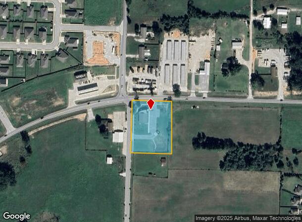
Property Record
2103 Slack St, Pea Ridge, AR 72751
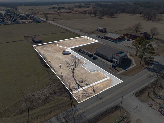
This Property Is For Sale
NEARBY LISTINGS FOR SALE OR LEASE
Property Detail
2103 Slack St
13-00124-027
Sugar Creek Residential Community Phase
Medicalbuilding
A PART OF THE NORTHWEST QUARTER OF THE NORTHEAST QUARTER OF SECTION 2, TOWNSHIP 20 NORTH, RANGE 30 WEST, BENTON COUNTY, ARKANSAS, BEING MORE PARTICULARLY DESCRIBED AS FOLLOWS: BEGINNING AT THE NORTHWEST CORNER OF THE SAID FORTY ACRE TRACT, AND RUNNIN
X
Benton
29119C0450D
Arkansas
2025
Outlying Benton County
2025
Fayetteville/Springdale/Rogers
020102
Fayetteville-Springdale-Rogers, AR-MO
DEMOGRAPHICS near 2103 Slack St
1 Mile
3 Mile
5 Mile
2024 Total Population
2,786
12,206
30,354
2029 Population
3,358
14,515
35,836
Pop Growth 2024-2029
+ 20.53%
+ 18.92%
+ 18.06%
Average Age
38
38
39
2024 Total Households
977
4,323
10,923
HH Growth 2024-2029
+ 20.68%
+ 18.92%
+ 18.06%
Median Household Inc
$90,037
$80,778
$89,703
Avg Household Size
2.80
2.80
2.70
2024 Avg HH Vehicles
2.00
2.00
2.00
Median Home Value
$232,624
$229,468
$260,711
Median Year Built
1997
1996
1998
Nearby Places
Map Layers
Map Styles
 Street
 Aerial
- Restaurants
- Banks
- Shops
- Fitness
- Groceries
PUBLIC TRANSPORTATION
AIRPORT
Northwest Arkansas Ntl
DRIVE
WALK
Distance
Northwest Arkansas Ntl
38 min
20.3 mi
Freight Ports
Tulsa Port of Inola
DRIVE
WALK
Distance
Tulsa Port of Inola
125 min
105.5 mi
Nearby Properties
Address
Land Use
TOTAL SIZE
Lot Size
Zoning
Address
Land Use
TOTAL SIZE
Lot Size
Zoning
28,501 SF
5.95 AC
Address
Land Use
TOTAL SIZE
Lot Size
Zoning
7,650 SF
5.63 AC
Address
Land Use
TOTAL SIZE
Lot Size
Zoning
41,940 SF
36.20 AC
Address
Land Use
TOTAL SIZE
Lot Size
Zoning
146,778 SF
10.32 AC
Address
Land Use
TOTAL SIZE
Lot Size
Zoning
5,936 SF
1.03 AC
Address
Land Use
TOTAL SIZE
Lot Size
Zoning
6,870 SF
1.66 AC
Address
Land Use
TOTAL SIZE
Lot Size
Zoning
60,356 SF
3.48 AC
Address
Land Use
TOTAL SIZE
Lot Size
Zoning
6,088 SF
1.51 AC
Address
Land Use
TOTAL SIZE
Lot Size
Zoning
22,141 SF
2.21 AC
Address
Land Use
TOTAL SIZE
Lot Size
Zoning
2,027 SF
1.07 AC
Address
Land Use
TOTAL SIZE
Lot Size
Zoning
7,114 SF
1.50 AC
Address
Land Use
TOTAL SIZE
Lot Size
Zoning
20,883 SF
6.35 AC
Address
Land Use
TOTAL SIZE
Lot Size
Zoning
8,598 SF
0.91 AC
Address
Land Use
TOTAL SIZE
Lot Size
Zoning
3,960 SF
1.13 AC
Address
Land Use
TOTAL SIZE
Lot Size
Zoning
13,056 SF
2.41 AC
Address
Land Use
TOTAL SIZE
Lot Size
Zoning
11,738 SF
2.04 AC
Address
Land Use
TOTAL SIZE
Lot Size
Zoning
6,811 SF
0.95 AC
Address
Land Use
TOTAL SIZE
Lot Size
Zoning
3,667 SF
1.15 AC
Address
Land Use
TOTAL SIZE
Lot Size
Zoning
2,904 SF
0.86 AC
Address
Land Use
TOTAL SIZE
Lot Size
Zoning
6,400 SF
2.86 AC
Address
Land Use
TOTAL SIZE
Lot Size
Zoning
10,920 SF
0.89 AC
Address
Land Use
TOTAL SIZE
Lot Size
Zoning
14,820 SF
1.33 AC
Address
Land Use
TOTAL SIZE
Lot Size
Zoning
7,862 SF
91.40 AC
Address
Land Use
TOTAL SIZE
Lot Size
Zoning
9,666 SF
1.53 AC
Address
Land Use
TOTAL SIZE
Lot Size
Zoning
11,200 SF
1.16 AC
Address
Land Use
TOTAL SIZE
Lot Size
Zoning
7,680 SF
0.95 AC
Address
Land Use
TOTAL SIZE
Lot Size
Zoning
12,208 SF
1.45 AC
Address
Land Use
TOTAL SIZE
Lot Size
Zoning
2,656 SF
0.27 AC
Address
Land Use
TOTAL SIZE
Lot Size
Zoning
2,290 SF
0.95 AC
The World's #1 Commercial Real Estate Marketplace
Connect with us
© 2025 CoStar Group
The information above has been obtained from sources believed reliable. While we do not doubt its accuracy we have not verified it and make no guarantee, warranty or representation about it. It is your responsibility to independently confirm its accuracy and completeness. Any projections, opinions, assumptions, or estimates used are for example only and do not represent the current or future performance of the property. The value of this transaction to you depends on tax and other factors which should be evaluated by your tax, financial, and legal advisors. You and your advisors should conduct a careful, independent investigation of the property to determine to your satisfaction the suitability of the property for your needs.