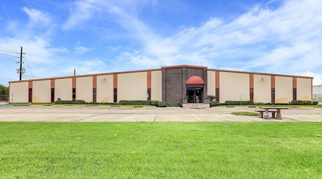
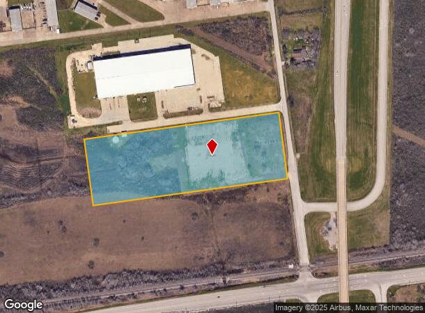
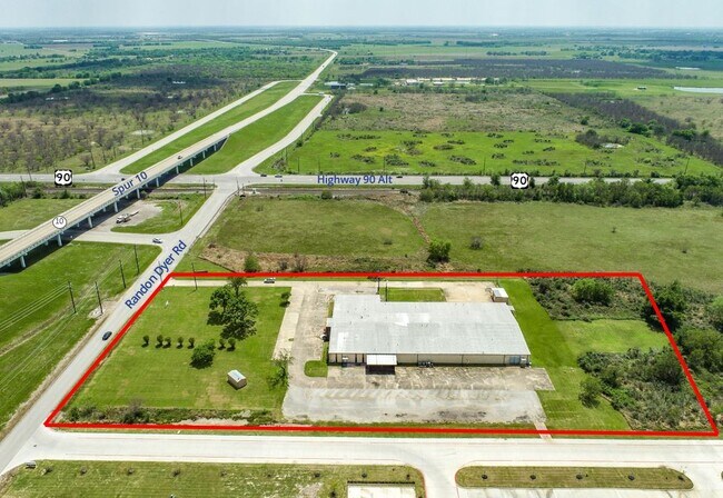
Property Record
2105 Randon Dyer Rd, Rosenberg, TX 77471
NEARBY LISTINGS FOR SALE OR LEASE
Property Detail
2105 Randon Dyer Rd
0374-13-006-6201-903
Yandell Ferris
Commercialnec
0374 YANDELL FERRIS, ACRES 7.2195
X
Fort Bend
48157C0225L
Texas
2024
8.73 AC
2025
Sugar Land
675800
Houston
28,560 SF
Houston-The Woodlands-Sugar Land, TX
DEMOGRAPHICS near 2105 Randon Dyer Rd
1 Mile
3 Mile
5 Mile
2024 Total Population
66
987
12,747
2029 Population
77
1,180
15,269
Pop Growth 2024-2029
+ 16.67%
+ 19.55%
+ 19.79%
Average Age
38
37
37
2024 Total Households
22
312
4,110
HH Growth 2024-2029
+ 18.18%
+ 20.19%
+ 20.34%
Median Household Inc
$61,875
$66,472
$58,040
Avg Household Size
3.10
3.20
3.10
2024 Avg HH Vehicles
2.00
2.00
2.00
Median Home Value
$199,999
$150,000
$154,955
Median Year Built
1982
1984
1986
Nearby Places
Map Layers
Map Styles
 Street
 Aerial
- Restaurants
- Banks
- Shops
- Fitness
- Groceries
SALE & LEASE HISTORY
LISTING DATE
SALE/LEASE

Oct 20, 2020
For Sale
Oct 20, 2020
For Lease
Nearby Properties
Address
Land Use
TOTAL SIZE
Lot Size
Zoning
Address
Land Use
TOTAL SIZE
Lot Size
Zoning
37.08 AC
Address
Land Use
TOTAL SIZE
Lot Size
Zoning
19.57 AC
OY
Address
Land Use
TOTAL SIZE
Lot Size
Zoning
11,800 SF
9.26 AC
S
Address
Land Use
TOTAL SIZE
Lot Size
Zoning
105,350 SF
11.50 AC
R
Address
Land Use
TOTAL SIZE
Lot Size
Zoning
220,453 SF
142.24 AC
SQ
Address
Land Use
TOTAL SIZE
Lot Size
Zoning
51,250 SF
10.01 AC
S
Address
Land Use
TOTAL SIZE
Lot Size
Zoning
2,064 SF
93.87 AC
QO
Address
Land Use
TOTAL SIZE
Lot Size
Zoning
10,737 SF
8.26 AC
Address
Land Use
TOTAL SIZE
Lot Size
Zoning
139,047 SF
49.85 AC
Address
Land Use
TOTAL SIZE
Lot Size
Zoning
40,876 SF
7.69 AC
S
Address
Land Use
TOTAL SIZE
Lot Size
Zoning
33,106 SF
6 AC
J
Address
Land Use
TOTAL SIZE
Lot Size
Zoning
28,690 SF
4.01 AC
J
Address
Land Use
TOTAL SIZE
Lot Size
Zoning
20,785 SF
10 AC
QS
Address
Land Use
TOTAL SIZE
Lot Size
Zoning
15,396 SF
3.27 AC
Address
Land Use
TOTAL SIZE
Lot Size
Zoning
68.41 AC
Y
Address
Land Use
TOTAL SIZE
Lot Size
Zoning
72.55 AC
Address
Land Use
TOTAL SIZE
Lot Size
Zoning
1,260 SF
36.99 AC
YOQT
Address
Land Use
TOTAL SIZE
Lot Size
Zoning
13,280 SF
17.10 AC
YZ
Address
Land Use
TOTAL SIZE
Lot Size
Zoning
177,887 SF
37 AC
YQM
Address
Land Use
TOTAL SIZE
Lot Size
Zoning
4,104 SF
3.77 AC
M
Address
Land Use
TOTAL SIZE
Lot Size
Zoning
9.95 AC
S
Address
Land Use
TOTAL SIZE
Lot Size
Zoning
78 AC
SO
Address
Land Use
TOTAL SIZE
Lot Size
Zoning
11.50 AC
Address
Land Use
TOTAL SIZE
Lot Size
Zoning
21,190 SF
10 AC
ST
Address
Land Use
TOTAL SIZE
Lot Size
Zoning
68.80 AC
Address
Land Use
TOTAL SIZE
Lot Size
Zoning
65.97 AC
QY
Address
Land Use
TOTAL SIZE
Lot Size
Zoning
17,532 SF
5.98 AC
SQ
Address
Land Use
TOTAL SIZE
Lot Size
Zoning
1,100 SF
6.21 AC
M
Address
Land Use
TOTAL SIZE
Lot Size
Zoning
11.44 AC
Address
Land Use
TOTAL SIZE
Lot Size
Zoning
1,112 SF
124.60 AC
OYNQ
The World's #1 Commercial Real Estate Marketplace
Connect with us
© 2025 CoStar Group
The information above has been obtained from sources believed reliable. While we do not doubt its accuracy we have not verified it and make no guarantee, warranty or representation about it. It is your responsibility to independently confirm its accuracy and completeness. Any projections, opinions, assumptions, or estimates used are for example only and do not represent the current or future performance of the property. The value of this transaction to you depends on tax and other factors which should be evaluated by your tax, financial, and legal advisors. You and your advisors should conduct a careful, independent investigation of the property to determine to your satisfaction the suitability of the property for your needs.