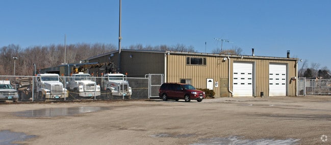
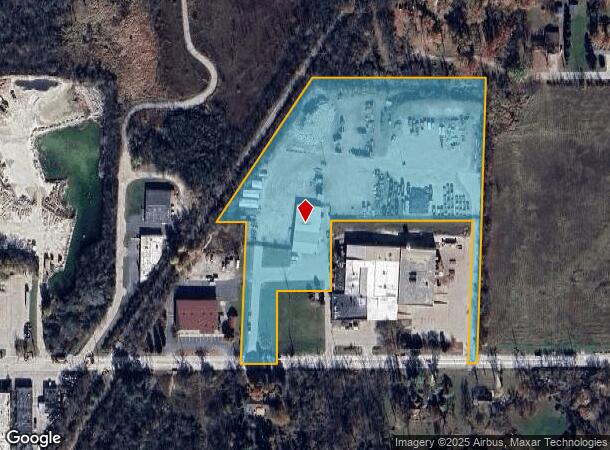
Property Record
21052 W Good Hope Rd, Lannon, WI 53046


NEARBY LISTINGS FOR SALE OR LEASE
-
-
View all Lannon listings for sale on LoopNet.com
Property Detail
21052 W Good Hope Rd
Milwaukee-Waukesha-West Allis, WI
PT SE1/4 SEC 18 T8N R20E ;COM S1/4 COR E 387.00 FT THE BGN; E 104.15 FT; N 208.71 FT; E 154.35 FT; N 200.00 FT; E 405.76 FT; S0200W 408.84 FT; E 25.00 FT; N0200E 817.00 FT; W 494.27 FT; S3422W 494.33 FT; E 84.07 FT; S0200W 408.84 FT TO BGN DOC# 40846
LANV-0072-988
Waukesha
Commercialnec
Wisconsin
X
8
55133C0093H
7.72 AC
2024
North/Sussex
2024
Milwaukee/Madison
200300
DEMOGRAPHICS near 21052 W Good Hope Rd
1 Mile
3 Mile
5 Mile
2024 Total Population
2,083
17,084
64,067
2029 Population
2,100
17,264
64,791
Pop Growth 2024-2029
+ 0.82%
+ 1.05%
+ 1.13%
Average Age
42
45
43
2024 Total Households
835
6,963
25,726
HH Growth 2024-2029
+ 0.84%
+ 1.12%
+ 0.96%
Median Household Inc
$80,064
$89,357
$101,290
Avg Household Size
2.50
2.40
2.50
2024 Avg HH Vehicles
2.00
2.00
2.00
Median Home Value
$292,020
$323,936
$334,760
Median Year Built
1992
1986
1983
Nearby Places
Map Layers
Map Styles
 Street
 Aerial
- Restaurants
- Banks
- Shops
- Fitness
- Groceries
PUBLIC TRANSPORTATION
AIRPORT
General Mitchell International
DRIVE
WALK
Distance
General Mitchell International
43 min
26.5 mi
Nearby Properties
Address
Land Use
TOTAL SIZE
Lot Size
Zoning
Address
Land Use
TOTAL SIZE
Lot Size
Zoning
145,836 SF
11 AC
Address
Land Use
TOTAL SIZE
Lot Size
Zoning
294,486 SF
12.78 AC
Address
Land Use
TOTAL SIZE
Lot Size
Zoning
74.81 AC
Address
Land Use
TOTAL SIZE
Lot Size
Zoning
9.61 AC
Address
Land Use
TOTAL SIZE
Lot Size
Zoning
145,844 SF
27.98 AC
Address
Land Use
TOTAL SIZE
Lot Size
Zoning
24.03 AC
Address
Land Use
TOTAL SIZE
Lot Size
Zoning
Address
Land Use
TOTAL SIZE
Lot Size
Zoning
104,642 SF
7.06 AC
Address
Land Use
TOTAL SIZE
Lot Size
Zoning
302,895 SF
7.90 AC
Address
Land Use
TOTAL SIZE
Lot Size
Zoning
245,615 SF
15.88 AC
Address
Land Use
TOTAL SIZE
Lot Size
Zoning
7.31 AC
Address
Land Use
TOTAL SIZE
Lot Size
Zoning
12.64 AC
Address
Land Use
TOTAL SIZE
Lot Size
Zoning
14.12 AC
Address
Land Use
TOTAL SIZE
Lot Size
Zoning
34.36 AC
Address
Land Use
TOTAL SIZE
Lot Size
Zoning
Address
Land Use
TOTAL SIZE
Lot Size
Zoning
1.61 AC
Address
Land Use
TOTAL SIZE
Lot Size
Zoning
85,193 SF
3.71 AC
Address
Land Use
TOTAL SIZE
Lot Size
Zoning
18.03 AC
Address
Land Use
TOTAL SIZE
Lot Size
Zoning
31,144 SF
26.95 AC
Address
Land Use
TOTAL SIZE
Lot Size
Zoning
10.17 AC
Address
Land Use
TOTAL SIZE
Lot Size
Zoning
Address
Land Use
TOTAL SIZE
Lot Size
Zoning
Address
Land Use
TOTAL SIZE
Lot Size
Zoning
27,148 SF
5.92 AC
Address
Land Use
TOTAL SIZE
Lot Size
Zoning
5.87 AC
Address
Land Use
TOTAL SIZE
Lot Size
Zoning
8.01 AC
Address
Land Use
TOTAL SIZE
Lot Size
Zoning
87,390 SF
4.48 AC
Address
Land Use
TOTAL SIZE
Lot Size
Zoning
47,933 SF
17.45 AC
Address
Land Use
TOTAL SIZE
Lot Size
Zoning
63,478 SF
4.32 AC
Address
Land Use
TOTAL SIZE
Lot Size
Zoning
63,478 SF
4.10 AC
Address
Land Use
TOTAL SIZE
Lot Size
Zoning
3.99 AC
The World's #1 Commercial Real Estate Marketplace
Connect with us
© 2025 CoStar Group
The information above has been obtained from sources believed reliable. While we do not doubt its accuracy we have not verified it and make no guarantee, warranty or representation about it. It is your responsibility to independently confirm its accuracy and completeness. Any projections, opinions, assumptions, or estimates used are for example only and do not represent the current or future performance of the property. The value of this transaction to you depends on tax and other factors which should be evaluated by your tax, financial, and legal advisors. You and your advisors should conduct a careful, independent investigation of the property to determine to your satisfaction the suitability of the property for your needs.