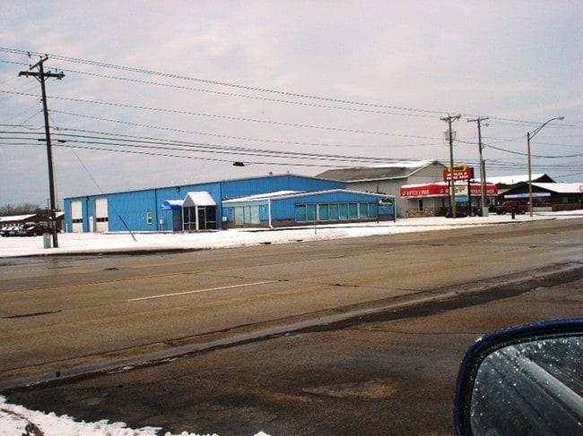
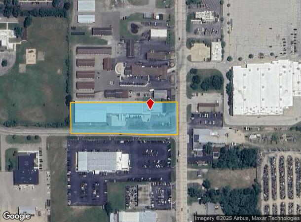
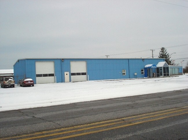
Property Record
2106 M 139, Benton Harbor, MI 49022
NEARBY LISTINGS FOR SALE OR LEASE
Property Detail
2106 M 139
11-03-0031-0040-35-0
COMBINED ON 11/22/2016 FROM 03-0031-0040-33-8, 03-0031-0040-34-6; BEG 33? N89DEG28?W OF E1/4 COR SEC 31 T4S R18W TH N89DEG28?W 626? TH N00DEG17?45?W 146.4? TH S89DEG29?07?E 626.15? TH S00DEG17?45?E 146.4? TO POB
Storemultistory
Berrien
X
Michigan
26021C0108C
2.10 AC
2024
Michigan Southwest Area
2025
Other Market Areas
002000
Niles-Benton Harbor, MI
18,584 SF
DEMOGRAPHICS near 2106 M 139
1 Mile
3 Mile
5 Mile
2024 Total Population
3,652
32,166
51,919
2029 Population
3,555
31,687
51,086
Pop Growth 2024-2029
(2.66%)
(1.49%)
(1.60%)
Average Age
42
39
41
2024 Total Households
1,722
13,172
21,476
HH Growth 2024-2029
(2.85%)
(1.82%)
(1.89%)
Median Household Inc
$34,166
$43,850
$52,998
Avg Household Size
2.00
2.30
2.30
2024 Avg HH Vehicles
1.00
2.00
2.00
Median Home Value
$108,286
$174,145
$209,413
Median Year Built
1960
1960
1964
Nearby Places
Map Layers
Map Styles
 Street
 Aerial
- Restaurants
- Banks
- Shops
- Fitness
- Groceries
PUBLIC TRANSPORTATION
AIRPORT
South Bend International
DRIVE
WALK
Distance
South Bend International
36 min
32.5 mi
Nearby Properties
Address
Land Use
TOTAL SIZE
Lot Size
Zoning
Address
Land Use
TOTAL SIZE
Lot Size
Zoning
313,588 SF
11.48 AC
DISTRICT A
Address
Land Use
TOTAL SIZE
Lot Size
Zoning
Address
Land Use
TOTAL SIZE
Lot Size
Zoning
200,321 SF
15.47 AC
D1 COMM
Address
Land Use
TOTAL SIZE
Lot Size
Zoning
99,468 SF
10.07 AC
DISTRICT G
Address
Land Use
TOTAL SIZE
Lot Size
Zoning
87,978 SF
4.36 AC
R2 MDR
Address
Land Use
TOTAL SIZE
Lot Size
Zoning
218,334 SF
25.05 AC
Address
Land Use
TOTAL SIZE
Lot Size
Zoning
69,180 SF
3.58 AC
D1 COMM
Address
Land Use
TOTAL SIZE
Lot Size
Zoning
73,505 SF
4.02 AC
D1 COMM
Address
Land Use
TOTAL SIZE
Lot Size
Zoning
66,680 SF
3.42 AC
Address
Land Use
TOTAL SIZE
Lot Size
Zoning
296,788 SF
34 AC
D1 COMM
Address
Land Use
TOTAL SIZE
Lot Size
Zoning
30,889 SF
2.83 AC
CO-A
Address
Land Use
TOTAL SIZE
Lot Size
Zoning
258,549 SF
17.20 AC
C MULTI
Address
Land Use
TOTAL SIZE
Lot Size
Zoning
62,800 SF
3.06 AC
Address
Land Use
TOTAL SIZE
Lot Size
Zoning
53,504 SF
Address
Land Use
TOTAL SIZE
Lot Size
Zoning
171,165 SF
15.15 AC
D1 COMM
Address
Land Use
TOTAL SIZE
Lot Size
Zoning
61,732 SF
3.51 AC
D1 COMM
Address
Land Use
TOTAL SIZE
Lot Size
Zoning
42,610 SF
5.30 AC
C4 HEAVY
Address
Land Use
TOTAL SIZE
Lot Size
Zoning
112,503 SF
4.30 AC
C MULTI FA
Address
Land Use
TOTAL SIZE
Lot Size
Zoning
28,312 SF
4.30 AC
C
Address
Land Use
TOTAL SIZE
Lot Size
Zoning
45,270 SF
10.30 AC
C1 GEN COM
Address
Land Use
TOTAL SIZE
Lot Size
Zoning
75,050 SF
5.33 AC
NONE
Address
Land Use
TOTAL SIZE
Lot Size
Zoning
126,127 SF
11.84 AC
D1 COMM
Address
Land Use
TOTAL SIZE
Lot Size
Zoning
204,000 SF
34.08 AC
F HEAVY
Address
Land Use
TOTAL SIZE
Lot Size
Zoning
90,000 SF
7.62 AC
W
Address
Land Use
TOTAL SIZE
Lot Size
Zoning
391,928 SF
40.84 AC
F HEAVY
Address
Land Use
TOTAL SIZE
Lot Size
Zoning
84,732 SF
4.19 AC
C MULTI FA
Address
Land Use
TOTAL SIZE
Lot Size
Zoning
25,080 SF
I-1
Address
Land Use
TOTAL SIZE
Lot Size
Zoning
77,703 SF
28.05 AC
F HEAVY
Address
Land Use
TOTAL SIZE
Lot Size
Zoning
88,572 SF
15.70 AC
D1 COMM
Address
Land Use
TOTAL SIZE
Lot Size
Zoning
254,984 SF
25.04 AC
R-A RE
The World's #1 Commercial Real Estate Marketplace
Connect with us
© 2025 CoStar Group
The information above has been obtained from sources believed reliable. While we do not doubt its accuracy we have not verified it and make no guarantee, warranty or representation about it. It is your responsibility to independently confirm its accuracy and completeness. Any projections, opinions, assumptions, or estimates used are for example only and do not represent the current or future performance of the property. The value of this transaction to you depends on tax and other factors which should be evaluated by your tax, financial, and legal advisors. You and your advisors should conduct a careful, independent investigation of the property to determine to your satisfaction the suitability of the property for your needs.