Property Record
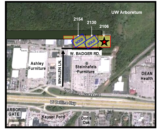
2106 W Badger Rd, Madison, WI 53713

Property Detail
2106 W Badger Rd
0709-343-1303-5
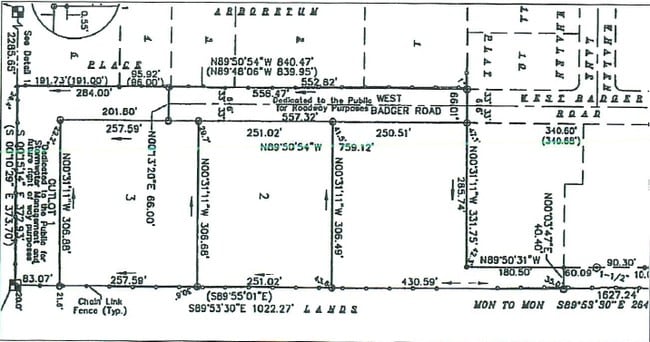
CERTIFIED SURVEY MAP NO 11769 AS RECORDED IN DANE COUNTY REGISTER OF DEEDS IN VO L 72 PAGE 114 OF CERTIFIED SURVEYS, LOT 3.
Commercialnec
Dane
CC
Wisconsin
B and X Area of moderate flood hazard, usually the area between the limits of the 100-year and 500-year floods.
72
2025
1.81 AC
2025
Near West Madison
001402
Milwaukee/Madison
5,280 SF
Madison, WI
NEARBY LISTINGS FOR SALE OR LEASE
-
-
-
-
No Photo
-
View all Madison listings for sale on LoopNet.com
DEMOGRAPHICS near 2106 W Badger Rd
1 mile
3 mile
5 mile
2025 Total Population
9,366
152,891
233,965
2030 Population
9,666
164,367
248,547
Pop Growth 2025-2030
+ 3.20%
+ 7.51%
+ 6.23%
Average Age
35
35
36
2025 Total Households
4,165
65,137
103,800
HH Growth 2025-2030
+ 3.60%
+ 8.06%
+ 6.62%
Median Household Inc
$58,618
$64,706
$69,646
Avg Household Size
2.20
2.10
2.10
2025 Avg HH Vehicles
1.00
1.00
1.00
Median Home Value
$280,694
$432,621
$411,491
Median Year Built
1980
1990
1983
Nearby Places
Map Layers
Map Styles
 Street
 Aerial
Layers
 Traffic
 Biking
Places
Listings with unknown addresses are not visible on the map
- Restaurants
- Banks
- Shops
- Fitness
- Groceries
PUBLIC TRANSPORTATION
AIRPORT
Dane County Regional/Truax Field
Drive
Walk
Distance
Dane County Regional/Truax Field
22 min
11.0 mi
Freight Ports
Port Milwaukee
Drive
Walk
Distance
Port Milwaukee
102 min
85.5 mi
SALE & LEASE HISTORY
LISTING DATE
SALE/LEASE

Sep 24, 2016
For Sale
May 04, 2021
For Sale
Nearby Properties
Address
Land Use
TOTAL SIZE
Lot Size
Zoning
Address
Land Use
TOTAL SIZE
Lot Size
Zoning
489,181 SF
1.82 AC
PD
Address
Land Use
TOTAL SIZE
Lot Size
Zoning
459,624 SF
1.62 AC
DC
Address
Land Use
TOTAL SIZE
Lot Size
Zoning
383,873 SF
0.99 AC
UMX
Address
Land Use
TOTAL SIZE
Lot Size
Zoning
324,916 SF
1.08 AC
PD
Address
Land Use
TOTAL SIZE
Lot Size
Zoning
466,790 SF
761.23 AC
PD
Address
Land Use
TOTAL SIZE
Lot Size
Zoning
8.42 AC
Address
Land Use
TOTAL SIZE
Lot Size
Zoning
21.49 AC
Address
Land Use
TOTAL SIZE
Lot Size
Zoning
374,339 SF
1.43 AC
UMX
Address
Land Use
TOTAL SIZE
Lot Size
Zoning
212,429 SF
0.66 AC
UMX
Address
Land Use
TOTAL SIZE
Lot Size
Zoning
210,515 SF
0.80 AC
UMX
Address
Land Use
TOTAL SIZE
Lot Size
Zoning
259,663 SF
414.76 AC
PD
Address
Land Use
TOTAL SIZE
Lot Size
Zoning
177,906 SF
5.49 AC
CC-T
Address
Land Use
TOTAL SIZE
Lot Size
Zoning
188,206 SF
0.80 AC
UMX
Address
Land Use
TOTAL SIZE
Lot Size
Zoning
18.97 AC
Address
Land Use
TOTAL SIZE
Lot Size
Zoning
212,259 SF
0.87 AC
UMX
Address
Land Use
TOTAL SIZE
Lot Size
Zoning
242,105 SF
2.23 AC
TSS
Address
Land Use
TOTAL SIZE
Lot Size
Zoning
24.62 AC
Address
Land Use
TOTAL SIZE
Lot Size
Zoning
174,113 SF
2.71 AC
PD
Address
Land Use
TOTAL SIZE
Lot Size
Zoning
202,376 SF
1.59 AC
PD
Address
Land Use
TOTAL SIZE
Lot Size
Zoning
230,007 SF
0.76 AC
PD
Address
Land Use
TOTAL SIZE
Lot Size
Zoning
153,684 SF
0.50 AC
DC
Address
Land Use
TOTAL SIZE
Lot Size
Zoning
181,893 SF
0.64 AC
PD
Address
Land Use
TOTAL SIZE
Lot Size
Zoning
14.47 AC
Address
Land Use
TOTAL SIZE
Lot Size
Zoning
135,478 SF
0.41 AC
UMX
Address
Land Use
TOTAL SIZE
Lot Size
Zoning
2.97 AC
Address
Land Use
TOTAL SIZE
Lot Size
Zoning
104,936 SF
1.19 AC
PD
Address
Land Use
TOTAL SIZE
Lot Size
Zoning
425,812 SF
1 AC
WP-17
Address
Land Use
TOTAL SIZE
Lot Size
Zoning
6.30 AC
Address
Land Use
TOTAL SIZE
Lot Size
Zoning
269,098 SF
0.98 AC
DC
Address
Land Use
TOTAL SIZE
Lot Size
Zoning
404,794 SF
4.86 AC
CC-T
The World's #1 Commercial Real Estate Marketplace
Connect with us
© 2026 CoStar Group
The information above has been obtained from sources believed reliable. While we do not doubt its accuracy we have not verified it and make no guarantee, warranty or representation about it. It is your responsibility to independently confirm its accuracy and completeness. Any projections, opinions, assumptions, or estimates used are for example only and do not represent the current or future performance of the property. The value of this transaction to you depends on tax and other factors which should be evaluated by your tax, financial, and legal advisors. You and your advisors should conduct a careful, independent investigation of the property to determine to your satisfaction the suitability of the property for your needs.