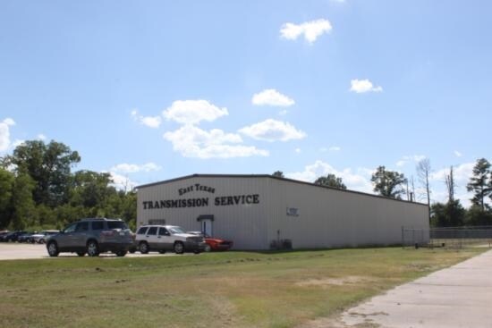
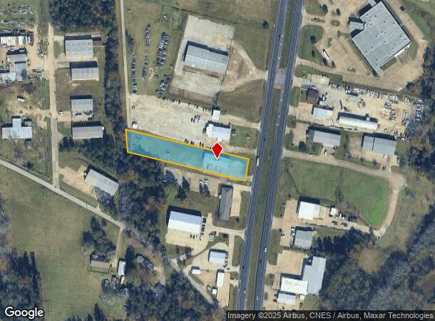
Property Record
2107 N John Redditt Dr, Lufkin, TX 75904

NEARBY LISTINGS FOR SALE OR LEASE
Property Detail
2107 N John Redditt Dr
Lufkin, TX
Smith Ottie L
72501
6145 SMITH OTTIE L. BLK 1 LOT 3.9
Distributionwarehouseregional
Angelina
X
Texas
48005C0235E
3
2025
1.36 AC
2025
Texas East Area
000301
Other Market Areas
5,200 SF
DEMOGRAPHICS near 2107 N John Redditt Dr
1 Mile
3 Mile
5 Mile
2024 Total Population
2,052
24,755
45,312
2029 Population
2,090
25,109
45,755
Pop Growth 2024-2029
+ 1.85%
+ 1.43%
+ 0.98%
Average Age
40
39
39
2024 Total Households
815
9,336
16,876
HH Growth 2024-2029
+ 1.72%
+ 1.44%
+ 0.99%
Median Household Inc
$47,916
$46,912
$51,074
Avg Household Size
2.40
2.50
2.60
2024 Avg HH Vehicles
2.00
2.00
2.00
Median Home Value
$135,211
$125,416
$138,528
Median Year Built
1989
1979
1980
Nearby Places
Map Layers
Map Styles
 Street
 Aerial
- Restaurants
- Banks
- Shops
- Fitness
- Groceries
SALE & LEASE HISTORY
LISTING DATE
SALE/LEASE

Mar 09, 2017
For Sale
Nearby Properties
Address
Land Use
TOTAL SIZE
Lot Size
Zoning
Address
Land Use
TOTAL SIZE
Lot Size
Zoning
34,528 SF
1.86 AC
CBD
Address
Land Use
TOTAL SIZE
Lot Size
Zoning
104,432 SF
10.06 AC
LM
Address
Land Use
TOTAL SIZE
Lot Size
Zoning
194,526 SF
14.99 AC
LBSU
Address
Land Use
TOTAL SIZE
Lot Size
Zoning
31,467 SF
41.44 AC
RL
Address
Land Use
TOTAL SIZE
Lot Size
Zoning
46,368 SF
7 AC
Address
Land Use
TOTAL SIZE
Lot Size
Zoning
423,495 SF
87.05 AC
LM
Address
Land Use
TOTAL SIZE
Lot Size
Zoning
107,432 SF
11.25 AC
A
Address
Land Use
TOTAL SIZE
Lot Size
Zoning
54,239 SF
7.51 AC
Address
Land Use
TOTAL SIZE
Lot Size
Zoning
70,046 SF
9 AC
LM
Address
Land Use
TOTAL SIZE
Lot Size
Zoning
34,536 SF
5.56 AC
Address
Land Use
TOTAL SIZE
Lot Size
Zoning
34,696 SF
2.76 AC
LBSU
Address
Land Use
TOTAL SIZE
Lot Size
Zoning
57,588 SF
5.07 AC
Address
Land Use
TOTAL SIZE
Lot Size
Zoning
32,834 SF
3.40 AC
LM
Address
Land Use
TOTAL SIZE
Lot Size
Zoning
199,212 SF
36.43 AC
LMSU
Address
Land Use
TOTAL SIZE
Lot Size
Zoning
8,060 SF
6.53 AC
RS
Address
Land Use
TOTAL SIZE
Lot Size
Zoning
61,488 SF
0.90 AC
CBSU
Address
Land Use
TOTAL SIZE
Lot Size
Zoning
119,266 SF
10.36 AC
A
Address
Land Use
TOTAL SIZE
Lot Size
Zoning
Address
Land Use
TOTAL SIZE
Lot Size
Zoning
26,890 SF
1.31 AC
LM
Address
Land Use
TOTAL SIZE
Lot Size
Zoning
12,615 SF
2.07 AC
LBD
Address
Land Use
TOTAL SIZE
Lot Size
Zoning
1,512 SF
6.31 AC
RL
Address
Land Use
TOTAL SIZE
Lot Size
Zoning
24,445 SF
0.94 AC
CB
Address
Land Use
TOTAL SIZE
Lot Size
Zoning
22,759 SF
2.35 AC
RL
Address
Land Use
TOTAL SIZE
Lot Size
Zoning
80,000 SF
12.20 AC
Address
Land Use
TOTAL SIZE
Lot Size
Zoning
14,535 SF
3.51 AC
Address
Land Use
TOTAL SIZE
Lot Size
Zoning
67,475 SF
2.78 AC
LB
Address
Land Use
TOTAL SIZE
Lot Size
Zoning
Address
Land Use
TOTAL SIZE
Lot Size
Zoning
4,752 SF
3.27 AC
RM
Address
Land Use
TOTAL SIZE
Lot Size
Zoning
63,156 SF
1.31 AC
CBSU
The World's #1 Commercial Real Estate Marketplace
Connect with us
© 2026 CoStar Group
The information above has been obtained from sources believed reliable. While we do not doubt its accuracy we have not verified it and make no guarantee, warranty or representation about it. It is your responsibility to independently confirm its accuracy and completeness. Any projections, opinions, assumptions, or estimates used are for example only and do not represent the current or future performance of the property. The value of this transaction to you depends on tax and other factors which should be evaluated by your tax, financial, and legal advisors. You and your advisors should conduct a careful, independent investigation of the property to determine to your satisfaction the suitability of the property for your needs.