Property Record
2108 Grandview Ave, Muscatine, IA 52761
NEARBY LISTINGS FOR SALE OR LEASE
-
-
View all Muscatine listings for sale on LoopNet.com
Property Detail
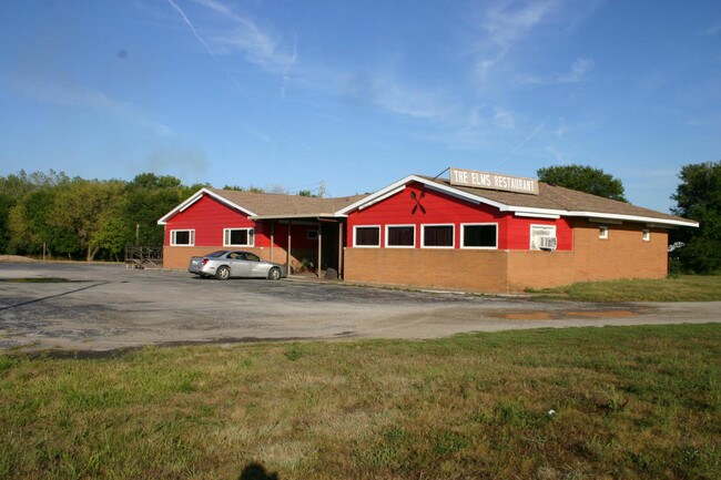
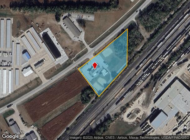
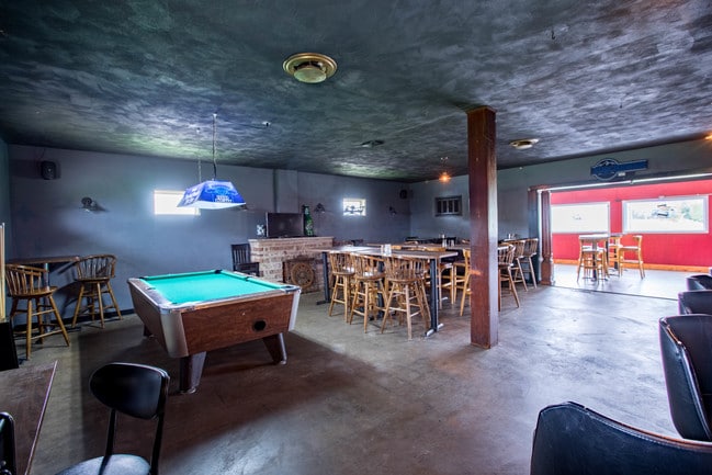
2108 Grandview Ave
Restaurantbuilding
9-76-2W PARCEL D SE SE 2006-04462
X
Muscatine
19139C0189D
Iowa
2024
3.04 AC
2025
Other Market Areas
050400
Muscatine, IA
3,940 SF
1309400041
DEMOGRAPHICS near 2108 Grandview Ave
1 Mile
3 Mile
5 Mile
2024 Total Population
1,194
12,401
26,414
2029 Population
1,177
12,096
25,797
Pop Growth 2024-2029
(1.42%)
(2.46%)
(2.34%)
Average Age
39
39
40
2024 Total Households
467
4,897
10,500
HH Growth 2024-2029
(1.28%)
(2.47%)
(2.34%)
Median Household Inc
$50,886
$55,880
$60,781
Avg Household Size
2.60
2.40
2.40
2024 Avg HH Vehicles
2.00
2.00
2.00
Median Home Value
$66,855
$124,732
$152,704
Median Year Built
1970
1954
1963
Nearby Places
Map Layers
Map Styles
 Street
 Aerial
- Restaurants
- Banks
- Shops
- Fitness
- Groceries
PUBLIC TRANSPORTATION
AIRPORT
Quad Cities International
DRIVE
WALK
Distance
Quad Cities International
49 min
38.0 mi
SALE & LEASE HISTORY
LISTING DATE
SALE/LEASE

Nov 06, 2019
For Sale
Nearby Properties
Address
Land Use
TOTAL SIZE
Lot Size
Zoning
Address
Land Use
TOTAL SIZE
Lot Size
Zoning
20,272 SF
42.56 AC
M2-HEAVY I
Address
Land Use
TOTAL SIZE
Lot Size
Zoning
90,669 SF
8.61 AC
R4-TWO FAM
Address
Land Use
TOTAL SIZE
Lot Size
Zoning
569,000 SF
26.43 AC
M2-HEAVY I
Address
Land Use
TOTAL SIZE
Lot Size
Zoning
94,425 SF
22.89 AC
R6-MULTI-F
Address
Land Use
TOTAL SIZE
Lot Size
Zoning
5,100 SF
38.80 AC
I2-HEAVY I
Address
Land Use
TOTAL SIZE
Lot Size
Zoning
300,000 SF
14.10 AC
M2-HEAVY I
Address
Land Use
TOTAL SIZE
Lot Size
Zoning
54,388 SF
2.35 AC
C2-CENTRAL
Address
Land Use
TOTAL SIZE
Lot Size
Zoning
22,142 SF
18.50 AC
M2-HEAVY I
Address
Land Use
TOTAL SIZE
Lot Size
Zoning
103,254 SF
0.58 AC
C2-CENTRAL
Address
Land Use
TOTAL SIZE
Lot Size
Zoning
17,244 SF
26.06 AC
M1
Address
Land Use
TOTAL SIZE
Lot Size
Zoning
8,340 SF
2.07 AC
C2-CENTRAL
Address
Land Use
TOTAL SIZE
Lot Size
Zoning
480 SF
17.95 AC
R3-SINGLE
Address
Land Use
TOTAL SIZE
Lot Size
Zoning
66,552 SF
1.62 AC
M2-HEAVY I
Address
Land Use
TOTAL SIZE
Lot Size
Zoning
59,781 SF
7.98 AC
R3-SINGLE
Address
Land Use
TOTAL SIZE
Lot Size
Zoning
34,620 SF
41.61 AC
R3-SINGLE
Address
Land Use
TOTAL SIZE
Lot Size
Zoning
1,248 SF
8.13 AC
M1-LIGHT I
Address
Land Use
TOTAL SIZE
Lot Size
Zoning
44,737 SF
0.96 AC
C2-CENTRAL
Address
Land Use
TOTAL SIZE
Lot Size
Zoning
44,164 SF
0.81 AC
C2-CENTRAL
Address
Land Use
TOTAL SIZE
Lot Size
Zoning
23,886 SF
0.96 AC
C2-CENTRAL
Address
Land Use
TOTAL SIZE
Lot Size
Zoning
8,957 SF
6.67 AC
M1-LIGHT I
Address
Land Use
TOTAL SIZE
Lot Size
Zoning
11,472 SF
0.59 AC
R5-MULTI-F
Address
Land Use
TOTAL SIZE
Lot Size
Zoning
84,180 SF
0.59 AC
C1-NEIGHBO
Address
Land Use
TOTAL SIZE
Lot Size
Zoning
16,224 SF
1.77 AC
S2-INSTITU
Address
Land Use
TOTAL SIZE
Lot Size
Zoning
1,600 SF
10.95 AC
R2-SINGLE
Address
Land Use
TOTAL SIZE
Lot Size
Zoning
396 SF
30.45 AC
M2-HEAVY I
Address
Land Use
TOTAL SIZE
Lot Size
Zoning
25,072 SF
2.28 AC
C2-CENTRAL
Address
Land Use
TOTAL SIZE
Lot Size
Zoning
37,104 SF
0.39 AC
C2-CENTRAL
Address
Land Use
TOTAL SIZE
Lot Size
Zoning
98,680 SF
Address
Land Use
TOTAL SIZE
Lot Size
Zoning
47,098 SF
62.89 AC
M1-LIGHT I
The World's #1 Commercial Real Estate Marketplace
Connect with us
© 2025 CoStar Group
The information above has been obtained from sources believed reliable. While we do not doubt its accuracy we have not verified it and make no guarantee, warranty or representation about it. It is your responsibility to independently confirm its accuracy and completeness. Any projections, opinions, assumptions, or estimates used are for example only and do not represent the current or future performance of the property. The value of this transaction to you depends on tax and other factors which should be evaluated by your tax, financial, and legal advisors. You and your advisors should conduct a careful, independent investigation of the property to determine to your satisfaction the suitability of the property for your needs.