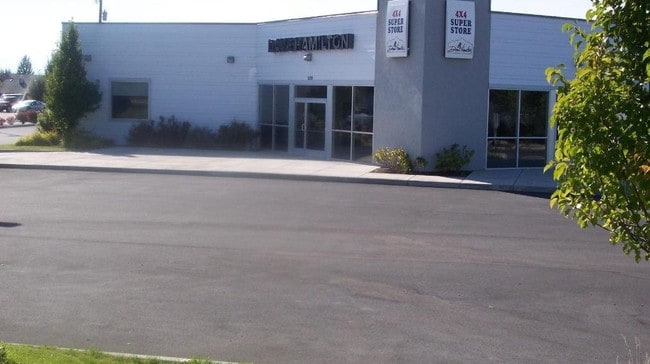
Property Record
2109 Nw 6Th St, Redmond, OR 97756

Property Detail
2109 Nw 6Th St
162871
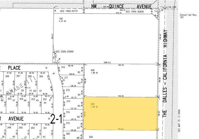
SEC 4 - BEG AT S1/4 COR TH N00 43 57 E 1318.09 FT TH N89 51 15 E 854.4 FT TH N00 28 39 E 592.04 F...
Commercialnec
DESCHUTES
C1
Oregon
B and X Area of moderate flood hazard, usually the area between the limits of the 100-year and 500-year floods.
1.98 AC
2025
Deschutes County
2025
Portland
000701
Bend, OR
9,096 SF
NEARBY LISTINGS FOR SALE OR LEASE
DEMOGRAPHICS near 2109 Nw 6Th St
1 mile
3 mile
5 mile
2025 Total Population
7,962
27,540
41,007
2030 Population
8,171
28,210
41,995
Pop Growth 2025-2030
+ 2.62%
+ 2.43%
+ 2.41%
Average Age
41
39
41
2025 Total Households
2,947
10,378
15,655
HH Growth 2025-2030
+ 2.54%
+ 2.37%
+ 2.39%
Median Household Inc
$83,206
$89,032
$91,792
Avg Household Size
2.60
2.60
2.60
2025 Avg HH Vehicles
2.00
2.00
2.00
Median Home Value
$492,873
$489,229
$551,181
Median Year Built
2003
2000
1999
Nearby Places
Map Layers
Map Styles
 Street
 Aerial
Layers
 Traffic
 Biking
Places
Listings with unknown addresses are not visible on the map
- Restaurants
- Banks
- Shops
- Fitness
- Groceries
PUBLIC TRANSPORTATION
AIRPORT
Roberts Field
Drive
Walk
Distance
Roberts Field
8 min
3.8 mi
Nearby Properties
Address
Land Use
TOTAL SIZE
Lot Size
Zoning
Address
Land Use
TOTAL SIZE
Lot Size
Zoning
1 SF
22.43 AC
M1
Address
Land Use
TOTAL SIZE
Lot Size
Zoning
22.43 AC
M1
Address
Land Use
TOTAL SIZE
Lot Size
Zoning
207,480 SF
28.78 AC
PF
Address
Land Use
TOTAL SIZE
Lot Size
Zoning
4,045 SF
10.95 AC
R5
Address
Land Use
TOTAL SIZE
Lot Size
Zoning
682.50 AC
AIRPORT
Address
Land Use
TOTAL SIZE
Lot Size
Zoning
106,239 SF
13.84 AC
PF
Address
Land Use
TOTAL SIZE
Lot Size
Zoning
106,239 SF
13.84 AC
PF
Address
Land Use
TOTAL SIZE
Lot Size
Zoning
217,211 SF
23.83 AC
C1
Address
Land Use
TOTAL SIZE
Lot Size
Zoning
80,000 SF
18.93 AC
PF
Address
Land Use
TOTAL SIZE
Lot Size
Zoning
165,971 SF
11.96 AC
C2
Address
Land Use
TOTAL SIZE
Lot Size
Zoning
1,584 SF
3.44 AC
R5
Address
Land Use
TOTAL SIZE
Lot Size
Zoning
102,711 SF
11.23 AC
M2
Address
Land Use
TOTAL SIZE
Lot Size
Zoning
85,512 SF
4.10 AC
R4
Address
Land Use
TOTAL SIZE
Lot Size
Zoning
37,618 SF
24.38 AC
PF-L
Address
Land Use
TOTAL SIZE
Lot Size
Zoning
50,425 SF
5.62 AC
PF
Address
Land Use
TOTAL SIZE
Lot Size
Zoning
16.01 AC
M1
Address
Land Use
TOTAL SIZE
Lot Size
Zoning
30,000 SF
16.01 AC
M1
Address
Land Use
TOTAL SIZE
Lot Size
Zoning
16.01 AC
M1
Address
Land Use
TOTAL SIZE
Lot Size
Zoning
119,934 SF
5.79 AC
C2
Address
Land Use
TOTAL SIZE
Lot Size
Zoning
46,736 SF
3.84 AC
PF
Address
Land Use
TOTAL SIZE
Lot Size
Zoning
7.50 AC
C4
Address
Land Use
TOTAL SIZE
Lot Size
Zoning
82,252 SF
7.50 AC
C4
Address
Land Use
TOTAL SIZE
Lot Size
Zoning
132,294 SF
11.16 AC
C1
Address
Land Use
TOTAL SIZE
Lot Size
Zoning
65,311 SF
3.74 AC
R5
Address
Land Use
TOTAL SIZE
Lot Size
Zoning
22.57 AC
M2
Address
Land Use
TOTAL SIZE
Lot Size
Zoning
27,300 SF
22.57 AC
M2
Address
Land Use
TOTAL SIZE
Lot Size
Zoning
1 SF
22.57 AC
M2
Address
Land Use
TOTAL SIZE
Lot Size
Zoning
36,638 SF
22.57 AC
M2
Address
Land Use
TOTAL SIZE
Lot Size
Zoning
11,800 SF
5.32 AC
C1
Address
Land Use
TOTAL SIZE
Lot Size
Zoning
54,743 SF
4.48 AC
C1
The World's #1 Commercial Real Estate Marketplace
Connect with us
© 2026 CoStar Group
The information above has been obtained from sources believed reliable. While we do not doubt its accuracy we have not verified it and make no guarantee, warranty or representation about it. It is your responsibility to independently confirm its accuracy and completeness. Any projections, opinions, assumptions, or estimates used are for example only and do not represent the current or future performance of the property. The value of this transaction to you depends on tax and other factors which should be evaluated by your tax, financial, and legal advisors. You and your advisors should conduct a careful, independent investigation of the property to determine to your satisfaction the suitability of the property for your needs.