No Photo
Property Record
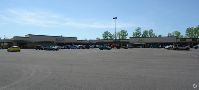
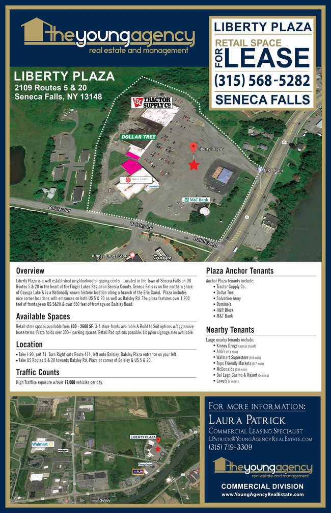
2109 Us Route 20, Seneca Falls, NY 13148


NEARBY LISTINGS FOR SALE OR LEASE
Property Detail
2109 Us Route 20
Seneca Falls, NY
REDUCED PER 1996 B.A.R. REDUCED PER 1999 B.A.R.
453289-033-000-0001-050-001-0000
Seneca
Regionalshoppingcenterormallwithanchorstore
New York
2025
50.001
2024
15.90 AC
950400
Ithaca/Elmira
78,312 SF
Other Market Areas
DEMOGRAPHICS near 2109 Us Route 20
1 Mile
3 Mile
5 Mile
2024 Total Population
872
12,604
17,048
2029 Population
842
12,353
16,755
Pop Growth 2024-2029
(3.44%)
(1.99%)
(1.72%)
Average Age
44
43
43
2024 Total Households
396
5,498
7,367
HH Growth 2024-2029
(3.54%)
(2.09%)
(1.83%)
Median Household Inc
$57,142
$56,701
$57,691
Avg Household Size
2.10
2.20
2.20
2024 Avg HH Vehicles
1.00
2.00
2.00
Median Home Value
$117,757
$103,457
$110,669
Median Year Built
1955
1952
1954
Nearby Places
Map Layers
Map Styles
 Street
 Aerial
- Restaurants
- Banks
- Shops
- Fitness
- Groceries
SALE & LEASE HISTORY
LISTING DATE
SALE/LEASE

Nov 13, 2017
For Sale
May 17, 2019
For Lease
May 07, 2022
For Lease
Mar 17, 2021
For Lease
Mar 07, 2018
For Lease
Nearby Properties
Address
Land Use
TOTAL SIZE
Lot Size
Zoning
Address
Land Use
TOTAL SIZE
Lot Size
Zoning
104,703 SF
35.80 AC
05 - COMME
Address
Land Use
TOTAL SIZE
Lot Size
Zoning
303,436 SF
67.40 AC
Address
Land Use
TOTAL SIZE
Lot Size
Zoning
163,212 SF
27.40 AC
R-1
Address
Land Use
TOTAL SIZE
Lot Size
Zoning
122,640 SF
17.31 AC
01 - NOT Z
Address
Land Use
TOTAL SIZE
Lot Size
Zoning
49,986 SF
1.30 AC
C-2
Address
Land Use
TOTAL SIZE
Lot Size
Zoning
154,484 SF
20.20 AC
C-2
Address
Land Use
TOTAL SIZE
Lot Size
Zoning
14,673 SF
1.30 AC
C-2
Address
Land Use
TOTAL SIZE
Lot Size
Zoning
Address
Land Use
TOTAL SIZE
Lot Size
Zoning
117,998 SF
17.80 AC
C-2
Address
Land Use
TOTAL SIZE
Lot Size
Zoning
12,652 SF
12 AC
C-2
Address
Land Use
TOTAL SIZE
Lot Size
Zoning
30,000 SF
5 AC
M-R
Address
Land Use
TOTAL SIZE
Lot Size
Zoning
48,796 SF
12.30 AC
05 - COMME
Address
Land Use
TOTAL SIZE
Lot Size
Zoning
67,810 SF
10 AC
05 - COMME
Address
Land Use
TOTAL SIZE
Lot Size
Zoning
52,335 SF
34.90 AC
Address
Land Use
TOTAL SIZE
Lot Size
Zoning
40,867 SF
4.30 AC
01 - NOT Z
Address
Land Use
TOTAL SIZE
Lot Size
Zoning
19,154 SF
102.20 AC
C-2
Address
Land Use
TOTAL SIZE
Lot Size
Zoning
2.57 AC
01 - NOT Z
Address
Land Use
TOTAL SIZE
Lot Size
Zoning
1 AC
L-C
Address
Land Use
TOTAL SIZE
Lot Size
Zoning
2,450 SF
43.20 AC
L-C
Address
Land Use
TOTAL SIZE
Lot Size
Zoning
5,269 SF
2.90 AC
R-1
Address
Land Use
TOTAL SIZE
Lot Size
Zoning
19,900 SF
13.20 AC
C-2
Address
Land Use
TOTAL SIZE
Lot Size
Zoning
83.50 AC
M-2
Address
Land Use
TOTAL SIZE
Lot Size
Zoning
41,786 SF
8.30 AC
01 - NOT Z
Address
Land Use
TOTAL SIZE
Lot Size
Zoning
2,951 SF
1.10 AC
01 - NOT Z
Address
Land Use
TOTAL SIZE
Lot Size
Zoning
2,458 SF
152.50 AC
M-2
Address
Land Use
TOTAL SIZE
Lot Size
Zoning
25,769 SF
0.67 AC
C-1
Address
Land Use
TOTAL SIZE
Lot Size
Zoning
30,200 SF
25 AC
C-2
Address
Land Use
TOTAL SIZE
Lot Size
Zoning
32,655 SF
1.72 AC
05 - COMME
Address
Land Use
TOTAL SIZE
Lot Size
Zoning
48,048 SF
1.88 AC
C-2
Address
Land Use
TOTAL SIZE
Lot Size
Zoning
48,289 SF
4.88 AC
01 - NOT Z
The World's #1 Commercial Real Estate Marketplace
Connect with us
© 2026 CoStar Group
The information above has been obtained from sources believed reliable. While we do not doubt its accuracy we have not verified it and make no guarantee, warranty or representation about it. It is your responsibility to independently confirm its accuracy and completeness. Any projections, opinions, assumptions, or estimates used are for example only and do not represent the current or future performance of the property. The value of this transaction to you depends on tax and other factors which should be evaluated by your tax, financial, and legal advisors. You and your advisors should conduct a careful, independent investigation of the property to determine to your satisfaction the suitability of the property for your needs.