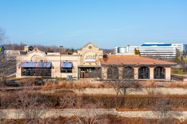
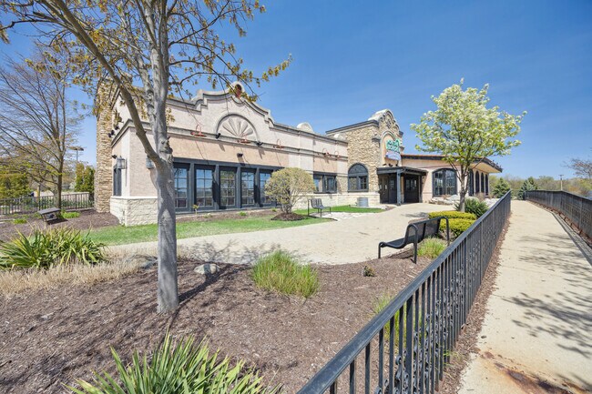
Property Record
21091 Haggerty Rd, Novi, MI 48375

Current Lease Availabilities
NEARBY LISTINGS FOR SALE OR LEASE
Property Detail
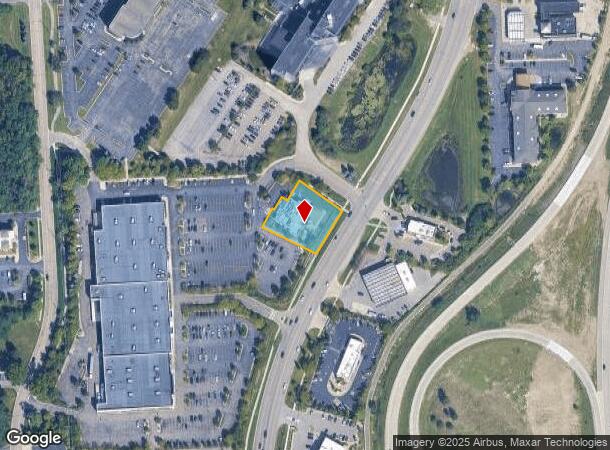
21091 Haggerty Rd
Detroit-Warren-Dearborn, MI
Oakland County Condominium
22-36-477-035
Oakland
Condominium
Michigan
X
0.60 AC
26163C0035E
Central I-96 Corridor
7,908 SF
Detroit
DEMOGRAPHICS near 21091 Haggerty Rd
1 Mile
3 Mile
5 Mile
2024 Total Population
5,649
75,534
172,543
2029 Population
5,552
73,677
168,242
Pop Growth 2024-2029
(1.72%)
(2.46%)
(2.49%)
Average Age
43
42
43
2024 Total Households
2,167
32,833
72,540
HH Growth 2024-2029
(1.75%)
(2.42%)
(2.46%)
Median Household Inc
$121,013
$99,707
$104,017
Avg Household Size
2.50
2.30
2.30
2024 Avg HH Vehicles
2.00
2.00
2.00
Median Home Value
$374,572
$340,927
$328,740
Median Year Built
1981
1981
1980
Nearby Places
Map Layers
Map Styles
 Street
 Aerial
- Restaurants
- Banks
- Shops
- Fitness
- Groceries
PUBLIC TRANSPORTATION
AIRPORT
Detroit Metro Wayne County
DRIVE
WALK
Distance
Detroit Metro Wayne County
32 min
23.5 mi
Windsor International
DRIVE
WALK
Distance
Windsor International
55 min
36.5 mi
Nearby Properties
Address
Land Use
TOTAL SIZE
Lot Size
Zoning
Address
Land Use
TOTAL SIZE
Lot Size
Zoning
1,393,561 SF
123.23 AC
AI
Address
Land Use
TOTAL SIZE
Lot Size
Zoning
886 SF
26.58 AC
GATEWY
Address
Land Use
TOTAL SIZE
Lot Size
Zoning
57.28 AC
RM-1
Address
Land Use
TOTAL SIZE
Lot Size
Zoning
250,699 SF
16.89 AC
SH
Address
Land Use
TOTAL SIZE
Lot Size
Zoning
182,121 SF
10.85 AC
HPUD
Address
Land Use
TOTAL SIZE
Lot Size
Zoning
406,560 SF
46.04 AC
AI
Address
Land Use
TOTAL SIZE
Lot Size
Zoning
42.06 AC
RM-1
Address
Land Use
TOTAL SIZE
Lot Size
Zoning
38 AC
RM-1
Address
Land Use
TOTAL SIZE
Lot Size
Zoning
14,463 SF
26.97 AC
TC-1
Address
Land Use
TOTAL SIZE
Lot Size
Zoning
325,281 SF
36.25 AC
AI
Address
Land Use
TOTAL SIZE
Lot Size
Zoning
102,878 SF
10.48 AC
CJ
Address
Land Use
TOTAL SIZE
Lot Size
Zoning
327,206 SF
29.93 AC
AI
Address
Land Use
TOTAL SIZE
Lot Size
Zoning
312,634 SF
20.19 AC
AI
Address
Land Use
TOTAL SIZE
Lot Size
Zoning
289,722 SF
7.34 AC
C-2
Address
Land Use
TOTAL SIZE
Lot Size
Zoning
228,748 SF
25.06 AC
AI
Address
Land Use
TOTAL SIZE
Lot Size
Zoning
30.32 AC
RM-1
Address
Land Use
TOTAL SIZE
Lot Size
Zoning
5,339 SF
20.10 AC
R-3
Address
Land Use
TOTAL SIZE
Lot Size
Zoning
214,242 SF
22.40 AC
AI
Address
Land Use
TOTAL SIZE
Lot Size
Zoning
264,994 SF
19.75 AC
AI
Address
Land Use
TOTAL SIZE
Lot Size
Zoning
Address
Land Use
TOTAL SIZE
Lot Size
Zoning
730,656 SF
13.73 AC
C-4
Address
Land Use
TOTAL SIZE
Lot Size
Zoning
206,496 SF
12.72 AC
PO
Address
Land Use
TOTAL SIZE
Lot Size
Zoning
25.93 AC
RM-1
Address
Land Use
TOTAL SIZE
Lot Size
Zoning
218,690 SF
10.02 AC
AI
Address
Land Use
TOTAL SIZE
Lot Size
Zoning
80,574 SF
19.95 AC
7MIPUD
Address
Land Use
TOTAL SIZE
Lot Size
Zoning
146,397 SF
10.59 AC
AI
Address
Land Use
TOTAL SIZE
Lot Size
Zoning
9,706 SF
40.41 AC
RM-1
Address
Land Use
TOTAL SIZE
Lot Size
Zoning
129,448 SF
9.37 AC
OSC
Address
Land Use
TOTAL SIZE
Lot Size
Zoning
6,984 SF
9.77 AC
RM-2
Address
Land Use
TOTAL SIZE
Lot Size
Zoning
217,331 SF
10.03 AC
AI
The World's #1 Commercial Real Estate Marketplace
Connect with us
© 2025 CoStar Group
The information above has been obtained from sources believed reliable. While we do not doubt its accuracy we have not verified it and make no guarantee, warranty or representation about it. It is your responsibility to independently confirm its accuracy and completeness. Any projections, opinions, assumptions, or estimates used are for example only and do not represent the current or future performance of the property. The value of this transaction to you depends on tax and other factors which should be evaluated by your tax, financial, and legal advisors. You and your advisors should conduct a careful, independent investigation of the property to determine to your satisfaction the suitability of the property for your needs.