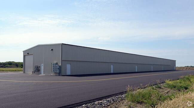
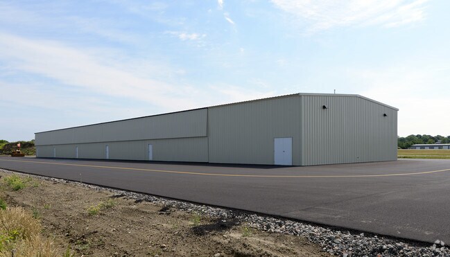
Property Record
211 Forest Ave, Middletown, RI 02842
NEARBY LISTINGS FOR SALE OR LEASE
Property Detail
211 Forest Ave
MIDD-000112-000000-000024A
Newport
Stateproperty
Rhode Island
X
24a
44005C0091J
222.84 AC
0
Newport County
2025
Providence
040400
Providence-Warwick, RI-MA
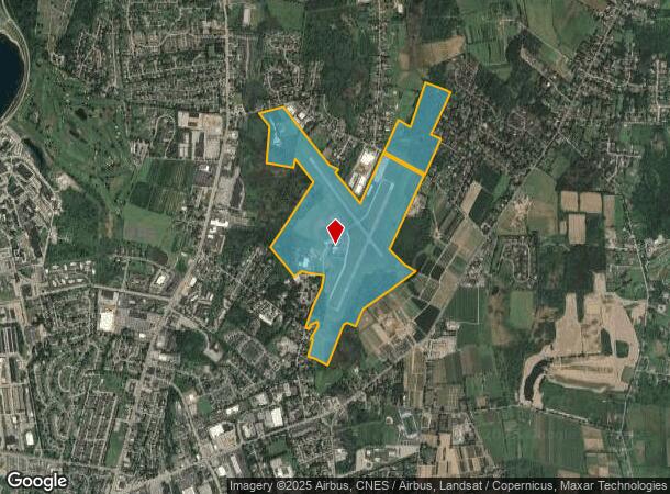
DEMOGRAPHICS near 211 Forest Ave
1 Mile
3 Mile
5 Mile
2024 Total Population
3,660
28,851
51,330
2029 Population
3,549
28,067
50,372
Pop Growth 2024-2029
(3.03%)
(2.72%)
(1.87%)
Average Age
43
43
44
2024 Total Households
1,484
11,651
21,639
HH Growth 2024-2029
(3.37%)
(3.05%)
(2.04%)
Median Household Inc
$83,100
$85,236
$89,217
Avg Household Size
2.30
2.30
2.20
2024 Avg HH Vehicles
2.00
2.00
2.00
Median Home Value
$482,657
$483,805
$592,232
Median Year Built
1973
1967
1960
Nearby Places
Map Layers
Map Styles
 Street
 Aerial
- Restaurants
- Banks
- Shops
- Fitness
- Groceries
PUBLIC TRANSPORTATION
AIRPORT
Rhode Island Tf Green International
DRIVE
WALK
Distance
Rhode Island Tf Green International
51 min
31.1 mi
Freight Ports
Port of Davisville, RI
DRIVE
WALK
Distance
Port of Davisville, RI
37 min
19.8 mi
Nearby Properties
Address
Land Use
TOTAL SIZE
Lot Size
Zoning
Address
Land Use
TOTAL SIZE
Lot Size
Zoning
60.03 AC
R40
Address
Land Use
TOTAL SIZE
Lot Size
Zoning
104.20 AC
P
Address
Land Use
TOTAL SIZE
Lot Size
Zoning
249,902 SF
27.88 AC
UV
Address
Land Use
TOTAL SIZE
Lot Size
Zoning
24.70 AC
RMA
Address
Land Use
TOTAL SIZE
Lot Size
Zoning
86,091 SF
6.50 AC
CI
Address
Land Use
TOTAL SIZE
Lot Size
Zoning
120.20 AC
HI
Address
Land Use
TOTAL SIZE
Lot Size
Zoning
157,806 SF
36.80 AC
R30
Address
Land Use
TOTAL SIZE
Lot Size
Zoning
82.64 AC
Address
Land Use
TOTAL SIZE
Lot Size
Zoning
217,212 SF
10.46 AC
R10
Address
Land Use
TOTAL SIZE
Lot Size
Zoning
33 AC
PA
Address
Land Use
TOTAL SIZE
Lot Size
Zoning
172,320 SF
10.14 AC
R10
Address
Land Use
TOTAL SIZE
Lot Size
Zoning
17.92 AC
RMA
Address
Land Use
TOTAL SIZE
Lot Size
Zoning
108,365 SF
5.15 AC
R10
Address
Land Use
TOTAL SIZE
Lot Size
Zoning
36,984 SF
10 AC
R10
Address
Land Use
TOTAL SIZE
Lot Size
Zoning
Address
Land Use
TOTAL SIZE
Lot Size
Zoning
151,202 SF
15.98 AC
PA
Address
Land Use
TOTAL SIZE
Lot Size
Zoning
12.18 AC
GBA
Address
Land Use
TOTAL SIZE
Lot Size
Zoning
130,460 SF
10.15 AC
OP
Address
Land Use
TOTAL SIZE
Lot Size
Zoning
26.66 AC
R20
Address
Land Use
TOTAL SIZE
Lot Size
Zoning
2,713 SF
36.08 AC
OS
Address
Land Use
TOTAL SIZE
Lot Size
Zoning
14.90 AC
Address
Land Use
TOTAL SIZE
Lot Size
Zoning
209.80 AC
Address
Land Use
TOTAL SIZE
Lot Size
Zoning
99,369 SF
15.88 AC
GBA
Address
Land Use
TOTAL SIZE
Lot Size
Zoning
65,600 SF
5.03 AC
GB
Address
Land Use
TOTAL SIZE
Lot Size
Zoning
7.65 AC
GBA
Address
Land Use
TOTAL SIZE
Lot Size
Zoning
53,770 SF
8.82 AC
GBA
Address
Land Use
TOTAL SIZE
Lot Size
Zoning
23,797 SF
1.89 AC
LB
Address
Land Use
TOTAL SIZE
Lot Size
Zoning
100,503 SF
2.87 AC
UV
Address
Land Use
TOTAL SIZE
Lot Size
Zoning
103,824 SF
6.97 AC
OB
Address
Land Use
TOTAL SIZE
Lot Size
Zoning
27,301 SF
0.54 AC
LB
The World's #1 Commercial Real Estate Marketplace
Connect with us
© 2025 CoStar Group
The information above has been obtained from sources believed reliable. While we do not doubt its accuracy we have not verified it and make no guarantee, warranty or representation about it. It is your responsibility to independently confirm its accuracy and completeness. Any projections, opinions, assumptions, or estimates used are for example only and do not represent the current or future performance of the property. The value of this transaction to you depends on tax and other factors which should be evaluated by your tax, financial, and legal advisors. You and your advisors should conduct a careful, independent investigation of the property to determine to your satisfaction the suitability of the property for your needs.