Property Record
211 E Wackerly St, Midland, MI 48642
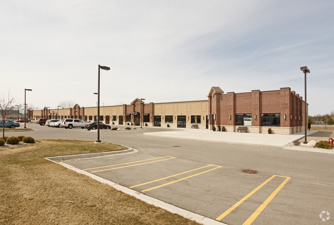

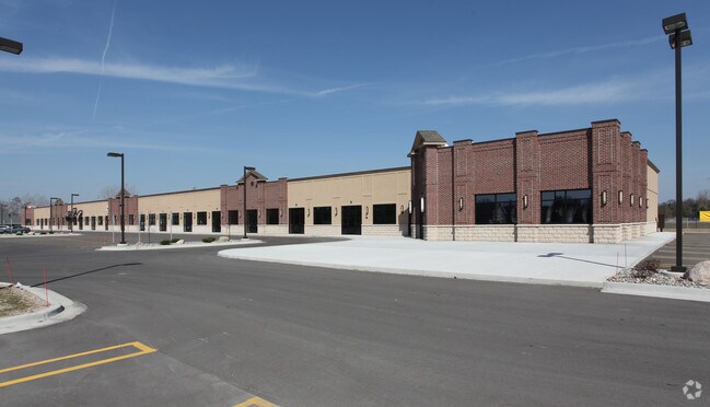
Property Detail
211 E Wackerly St
11-34-50-402
BEG 370.4 FT E OF SW COR SEC 34,N 274.74 FT,E 660 FT,S 274.2 W 660 FT TO BEG EXC HWY R/W T15NR2E
Stripcommercialcenter
Midland
RC
Michigan
B and X Area of moderate flood hazard, usually the area between the limits of the 100-year and 500-year floods.
3.65 AC
2024
Midland/Flint
2025
Other Market Areas
290902
Midland, MI
27,413 SF
NEARBY LISTINGS FOR SALE OR LEASE
DEMOGRAPHICS near 211 E Wackerly St
1 mile
3 mile
5 mile
2024 Total Population
5,294
36,274
49,495
2029 Population
5,266
36,303
49,643
Pop Growth 2024-2029
(0.53%)
+ 0.08%
+ 0.30%
Average Age
41
42
42
2024 Total Households
2,000
15,195
20,649
HH Growth 2024-2029
(0.60%)
+ 0.16%
+ 0.36%
Median Household Inc
$101,992
$75,270
$73,137
Avg Household Size
2.60
2.30
2.30
2024 Avg HH Vehicles
2.00
2.00
2.00
Median Home Value
$265,662
$212,268
$210,208
Median Year Built
1984
1971
1972
Nearby Places
Map Layers
Map Styles
 Street
 Aerial
Transit
 Traffic
 Biking
Places
Listings with unknown addresses are not visible on the map
- Restaurants
- Banks
- Shops
- Fitness
- Groceries
PUBLIC TRANSPORTATION
AIRPORT
MBS International
Drive
Walk
Distance
MBS International
24 min
15.8 mi
Freight Ports
Port of Toledo
Drive
Walk
Distance
Port of Toledo
198 min
174.3 mi
Nearby Properties
Address
Land Use
TOTAL SIZE
Lot Size
Zoning
Address
Land Use
TOTAL SIZE
Lot Size
Zoning
42,647 SF
12.42 AC
RA-4
Address
Land Use
TOTAL SIZE
Lot Size
Zoning
202,789 SF
139.19 AC
NC
Address
Land Use
TOTAL SIZE
Lot Size
Zoning
83,416 SF
1.21 AC
COM
Address
Land Use
TOTAL SIZE
Lot Size
Zoning
116,057 SF
120 AC
RA-1
Address
Land Use
TOTAL SIZE
Lot Size
Zoning
252,442 SF
70.03 AC
AG
Address
Land Use
TOTAL SIZE
Lot Size
Zoning
357,933 SF
33.35 AC
RC
Address
Land Use
TOTAL SIZE
Lot Size
Zoning
219,270 SF
20 AC
RB
Address
Land Use
TOTAL SIZE
Lot Size
Zoning
116,274 SF
4.59 AC
RC
Address
Land Use
TOTAL SIZE
Lot Size
Zoning
115,878 SF
7.53 AC
RB
Address
Land Use
TOTAL SIZE
Lot Size
Zoning
223,029 SF
18.50 AC
OS
Address
Land Use
TOTAL SIZE
Lot Size
Zoning
201,174 SF
27.52 AC
RC
Address
Land Use
TOTAL SIZE
Lot Size
Zoning
207,859 SF
21.12 AC
RC
Address
Land Use
TOTAL SIZE
Lot Size
Zoning
55,872 SF
3.85 AC
RC
Address
Land Use
TOTAL SIZE
Lot Size
Zoning
61,516 SF
5.31 AC
RC
Address
Land Use
TOTAL SIZE
Lot Size
Zoning
76,333 SF
10.01 AC
RB
Address
Land Use
TOTAL SIZE
Lot Size
Zoning
126,335 SF
11.79 AC
RC
Address
Land Use
TOTAL SIZE
Lot Size
Zoning
143.72 AC
LCMR
Address
Land Use
TOTAL SIZE
Lot Size
Zoning
53,950 SF
16.40 AC
RC
Address
Land Use
TOTAL SIZE
Lot Size
Zoning
55,926 SF
1.72 AC
CC
Address
Land Use
TOTAL SIZE
Lot Size
Zoning
99,327 SF
7.96 AC
RB
Address
Land Use
TOTAL SIZE
Lot Size
Zoning
64,769 SF
3.17 AC
RC
Address
Land Use
TOTAL SIZE
Lot Size
Zoning
81,009 SF
3.33 AC
RC
Address
Land Use
TOTAL SIZE
Lot Size
Zoning
81,373 SF
8.93 AC
RC
Address
Land Use
TOTAL SIZE
Lot Size
Zoning
74,532 SF
6.55 AC
RC
Address
Land Use
TOTAL SIZE
Lot Size
Zoning
40,763 SF
11 AC
RB
Address
Land Use
TOTAL SIZE
Lot Size
Zoning
88,104 SF
9 AC
RC
Address
Land Use
TOTAL SIZE
Lot Size
Zoning
62,440 SF
7.34 AC
RC
Address
Land Use
TOTAL SIZE
Lot Size
Zoning
67,173 SF
3.59 AC
RB
Address
Land Use
TOTAL SIZE
Lot Size
Zoning
104,458 SF
9.44 AC
RC
Address
Land Use
TOTAL SIZE
Lot Size
Zoning
38,127 SF
9.72 AC
IA
The World's #1 Commercial Real Estate Marketplace
Connect with us
© 2026 CoStar Group
The information above has been obtained from sources believed reliable. While we do not doubt its accuracy we have not verified it and make no guarantee, warranty or representation about it. It is your responsibility to independently confirm its accuracy and completeness. Any projections, opinions, assumptions, or estimates used are for example only and do not represent the current or future performance of the property. The value of this transaction to you depends on tax and other factors which should be evaluated by your tax, financial, and legal advisors. You and your advisors should conduct a careful, independent investigation of the property to determine to your satisfaction the suitability of the property for your needs.