Property Record
211 Founders Park Dr, Rapid City, SD 57701


Save to a Folder
{{folder.Name}}
{{folder.ListingIds.length}} Properties
{{folder.ListingIds.length}} Property
Create a New Folder
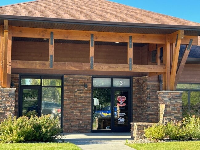
Property Detail
211 Founders Park Dr
Rapid City, SD
FOUNDERS PARK SUBD, LOT 2
0062059
Pennington
Officebuilding
South Dakota
AE The base floodplain where base flood elevations are provided. AE Zones are now used on new format FIRMs instead of A1-A30 Zones.
2
2025
1.33 AC
2025
Downtown Rapid City
010300
Other Market Areas
7,232 SF
NEARBY LISTINGS FOR SALE OR LEASE
DEMOGRAPHICS near 211 Founders Park Dr
1 mile
3 mile
5 mile
2025 Total Population
6,418
50,679
80,063
2030 Population
6,652
52,649
83,439
Pop Growth 2025-2030
+ 3.65%
+ 3.89%
+ 4.22%
Average Age
41
41
41
2025 Total Households
2,644
21,660
33,878
HH Growth 2025-2030
+ 4.01%
+ 4.18%
+ 4.47%
Median Household Inc
$61,040
$61,386
$70,481
Avg Household Size
2.00
2.10
2.20
2025 Avg HH Vehicles
2.00
2.00
2.00
Median Home Value
$293,652
$272,602
$302,559
Median Year Built
1963
1974
1981
Nearby Places
Map Layers
Map Styles
 Street
 Aerial
Layers
 Traffic
 Biking
Places
Listings with unknown addresses are not visible on the map
- Restaurants
- Banks
- Shops
- Fitness
- Groceries
PUBLIC TRANSPORTATION
AIRPORT
Rapid City Regional
Drive
Walk
Distance
Rapid City Regional
20 min
11.3 mi
Freight Ports
Port of Everett
Drive
Walk
Distance
Port of Everett
1 min
946.7 mi
SALE & LEASE HISTORY
LISTING DATE
SALE/LEASE

Sep 25, 2016
For Lease
Oct 25, 2023
For Lease
Mar 08, 2024
For Lease
Jun 02, 2017
For Lease
Jan 25, 2017
For Lease
Nearby Properties
Address
Land Use
TOTAL SIZE
Lot Size
Zoning
Address
Land Use
TOTAL SIZE
Lot Size
Zoning
5,244 SF
17.53 AC
Address
Land Use
TOTAL SIZE
Lot Size
Zoning
40,853 SF
8.09 AC
Address
Land Use
TOTAL SIZE
Lot Size
Zoning
19,728 SF
7.67 AC
Address
Land Use
TOTAL SIZE
Lot Size
Zoning
6,480 SF
11.58 AC
Address
Land Use
TOTAL SIZE
Lot Size
Zoning
48,204 SF
15.19 AC
Address
Land Use
TOTAL SIZE
Lot Size
Zoning
6,820 SF
10.60 AC
Address
Land Use
TOTAL SIZE
Lot Size
Zoning
188,360 SF
37.53 AC
Address
Land Use
TOTAL SIZE
Lot Size
Zoning
48,108 SF
38.14 AC
Address
Land Use
TOTAL SIZE
Lot Size
Zoning
26,807 SF
0.58 AC
Address
Land Use
TOTAL SIZE
Lot Size
Zoning
7,680 SF
9.34 AC
Address
Land Use
TOTAL SIZE
Lot Size
Zoning
29,226 SF
1.38 AC
Address
Land Use
TOTAL SIZE
Lot Size
Zoning
14,360 SF
2.07 AC
Address
Land Use
TOTAL SIZE
Lot Size
Zoning
28,584 SF
5.62 AC
Address
Land Use
TOTAL SIZE
Lot Size
Zoning
25,762 SF
5.74 AC
Address
Land Use
TOTAL SIZE
Lot Size
Zoning
62,209 SF
14.15 AC
Address
Land Use
TOTAL SIZE
Lot Size
Zoning
10,608 SF
10.90 AC
Address
Land Use
TOTAL SIZE
Lot Size
Zoning
50,656 SF
9.17 AC
Address
Land Use
TOTAL SIZE
Lot Size
Zoning
46,025 SF
36.26 AC
Address
Land Use
TOTAL SIZE
Lot Size
Zoning
147,325 SF
11.93 AC
Address
Land Use
TOTAL SIZE
Lot Size
Zoning
4,576 SF
4.85 AC
Address
Land Use
TOTAL SIZE
Lot Size
Zoning
162,960 SF
22.56 AC
Address
Land Use
TOTAL SIZE
Lot Size
Zoning
26,845 SF
3.49 AC
Address
Land Use
TOTAL SIZE
Lot Size
Zoning
227,112 SF
21.01 AC
Address
Land Use
TOTAL SIZE
Lot Size
Zoning
35,999 SF
3.01 AC
Address
Land Use
TOTAL SIZE
Lot Size
Zoning
65,922 SF
6 AC
Address
Land Use
TOTAL SIZE
Lot Size
Zoning
105,621 SF
10 AC
Address
Land Use
TOTAL SIZE
Lot Size
Zoning
5,448 SF
7.92 AC
Address
Land Use
TOTAL SIZE
Lot Size
Zoning
20,988 SF
4.13 AC
Address
Land Use
TOTAL SIZE
Lot Size
Zoning
3,008 SF
4.66 AC
Address
Land Use
TOTAL SIZE
Lot Size
Zoning
30,740 SF
3.22 AC
The World's #1 Commercial Real Estate Marketplace
Connect with us
© 2026 CoStar Group
The information above has been obtained from sources believed reliable. While we do not doubt its accuracy we have not verified it and make no guarantee, warranty or representation about it. It is your responsibility to independently confirm its accuracy and completeness. Any projections, opinions, assumptions, or estimates used are for example only and do not represent the current or future performance of the property. The value of this transaction to you depends on tax and other factors which should be evaluated by your tax, financial, and legal advisors. You and your advisors should conduct a careful, independent investigation of the property to determine to your satisfaction the suitability of the property for your needs.