Property Record
211 Main St, Columbia, SC 29201
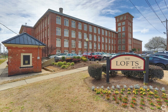

Property Detail
211 Main St
11302-11-01
422.3X248.1X341.1X124X419.1 #SU WHALEYS MILL APTS #PR 56-2146 55-8750 50-596
Apartment
Richland
C-1
South Carolina
AE The base floodplain where base flood elevations are provided. AE Zones are now used on new format FIRMs instead of A1-A30 Zones.
3.47 AC
2025
University Hill
2024
Columbia
002800
Columbia, SC
138,832 SF
NEARBY LISTINGS FOR SALE OR LEASE
-
-
-
-
-
No Photo
-
-
-
-
-
View all Columbia listings for sale on LoopNet.com
DEMOGRAPHICS near 211 Main St
1 mile
3 mile
5 mile
2025 Total Population
18,334
80,193
163,646
2030 Population
18,961
83,696
170,083
Pop Growth 2025-2030
+ 3.42%
+ 4.37%
+ 3.93%
Average Age
27
35
37
2025 Total Households
5,584
35,639
71,971
HH Growth 2025-2030
+ 4.14%
+ 4.84%
+ 4.26%
Median Household Inc
$27,005
$50,249
$53,400
Avg Household Size
1.90
1.90
2.00
2025 Avg HH Vehicles
2.00
2.00
2.00
Median Home Value
$439,329
$270,943
$248,745
Median Year Built
1971
1967
1970
Nearby Places
Map Layers
Map Styles
 Street
 Aerial
Layers
 Traffic
 Biking
Places
Listings with unknown addresses are not visible on the map
- Restaurants
- Banks
- Shops
- Fitness
- Groceries
PUBLIC TRANSPORTATION
COMMUTER RAIL
Columbia Amtrak Station (Silver Star - Amtrak)
Drive
Walk
Distance
Columbia Amtrak Station (Silver Star - Amtrak)
4 min
1.3 mi
AIRPORT
Columbia Metro
Drive
Walk
Distance
Columbia Metro
24 min
9.3 mi
Freight Ports
North Charleston Terminal
Drive
Walk
Distance
North Charleston Terminal
123 min
107.0 mi
Nearby Properties
Address
Land Use
TOTAL SIZE
Lot Size
Zoning
Address
Land Use
TOTAL SIZE
Lot Size
Zoning
501,365 SF
13.28 AC
O-I
Address
Land Use
TOTAL SIZE
Lot Size
Zoning
106,284 SF
10.83 AC
C-5
Address
Land Use
TOTAL SIZE
Lot Size
Zoning
100 SF
15.17 AC
C-1
Address
Land Use
TOTAL SIZE
Lot Size
Zoning
456,218 SF
1 AC
DAC
Address
Land Use
TOTAL SIZE
Lot Size
Zoning
413,000 SF
3.48 AC
MC
Address
Land Use
TOTAL SIZE
Lot Size
Zoning
160,510 SF
0.26 AC
DAC
Address
Land Use
TOTAL SIZE
Lot Size
Zoning
311,754 SF
1.78 AC
DAC
Address
Land Use
TOTAL SIZE
Lot Size
Zoning
440,418 SF
7.23 AC
M-1
Address
Land Use
TOTAL SIZE
Lot Size
Zoning
375,417 SF
3.92 AC
INS-GEN
Address
Land Use
TOTAL SIZE
Lot Size
Zoning
30,100 SF
3.45 AC
M-2
Address
Land Use
TOTAL SIZE
Lot Size
Zoning
2.07 AC
DAC
Address
Land Use
TOTAL SIZE
Lot Size
Zoning
603,525 SF
26.45 AC
RM-HD
Address
Land Use
TOTAL SIZE
Lot Size
Zoning
204,154 SF
1.37 AC
DAC
Address
Land Use
TOTAL SIZE
Lot Size
Zoning
530,349 SF
0.75 AC
DAC
Address
Land Use
TOTAL SIZE
Lot Size
Zoning
604,350 SF
10.33 AC
EC
Address
Land Use
TOTAL SIZE
Lot Size
Zoning
100 SF
9.81 AC
MC
Address
Land Use
TOTAL SIZE
Lot Size
Zoning
353,447 SF
0.53 AC
DAC
Address
Land Use
TOTAL SIZE
Lot Size
Zoning
383,491 SF
2.36 AC
C-3
Address
Land Use
TOTAL SIZE
Lot Size
Zoning
311,168 SF
3.98 AC
MC
Address
Land Use
TOTAL SIZE
Lot Size
Zoning
494,384 SF
1.67 AC
MC
Address
Land Use
TOTAL SIZE
Lot Size
Zoning
291,996 SF
0.78 AC
DAC
Address
Land Use
TOTAL SIZE
Lot Size
Zoning
354,235 SF
0.80 AC
DAC
Address
Land Use
TOTAL SIZE
Lot Size
Zoning
490,633 SF
13.20 AC
RM-2
Address
Land Use
TOTAL SIZE
Lot Size
Zoning
163,868 SF
4.35 AC
CAC
Address
Land Use
TOTAL SIZE
Lot Size
Zoning
90,588 SF
3.72 AC
DAC
Address
Land Use
TOTAL SIZE
Lot Size
Zoning
85,065 SF
2.43 AC
C-1
Address
Land Use
TOTAL SIZE
Lot Size
Zoning
100 SF
0.52 AC
C-1
Address
Land Use
TOTAL SIZE
Lot Size
Zoning
100 SF
4.49 AC
INS-GEN
Address
Land Use
TOTAL SIZE
Lot Size
Zoning
221,186 SF
1.31 AC
DAC
Address
Land Use
TOTAL SIZE
Lot Size
Zoning
319,842 SF
0.78 AC
DAC
The World's #1 Commercial Real Estate Marketplace
Connect with us
© 2026 CoStar Group
The information above has been obtained from sources believed reliable. While we do not doubt its accuracy we have not verified it and make no guarantee, warranty or representation about it. It is your responsibility to independently confirm its accuracy and completeness. Any projections, opinions, assumptions, or estimates used are for example only and do not represent the current or future performance of the property. The value of this transaction to you depends on tax and other factors which should be evaluated by your tax, financial, and legal advisors. You and your advisors should conduct a careful, independent investigation of the property to determine to your satisfaction the suitability of the property for your needs.