Property Record
211 Mount Airy Rd, Basking Ridge, NJ 07920

NEARBY LISTINGS FOR SALE OR LEASE
Property Detail
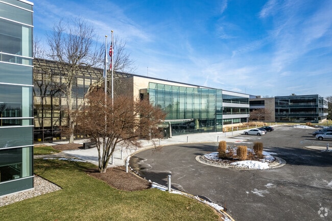
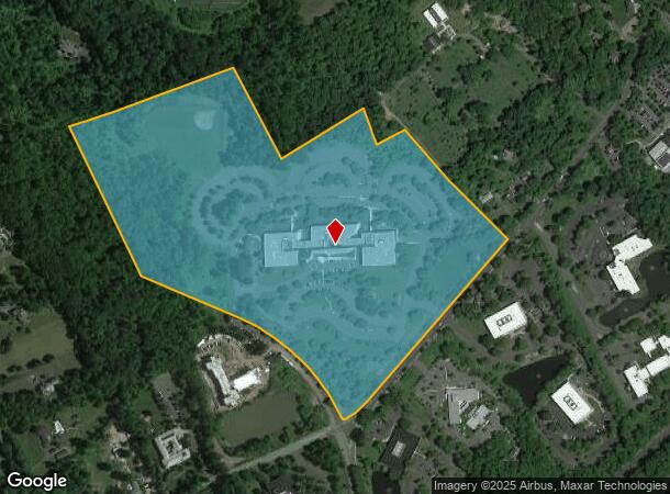
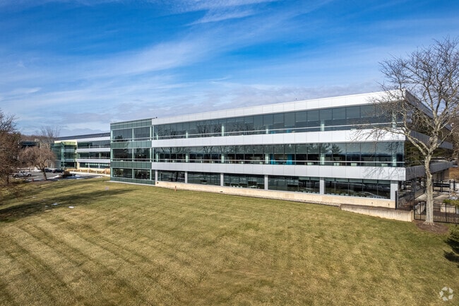
211 Mount Airy Rd
02-02301-0000-00029
ADDITIONAL LOTS: LEASE 306194
Officebuilding
Somerset
X
New Jersey
34035C0054E
29
2024
51.96 AC
2025
Route 78 East
052604
Northern New Jersey
300,000 SF
Newark, NJ-PA
DEMOGRAPHICS near 211 Mount Airy Rd
1 Mile
3 Mile
5 Mile
2024 Total Population
2,743
26,375
57,145
2029 Population
2,717
26,236
56,886
Pop Growth 2024-2029
(0.95%)
(0.53%)
(0.45%)
Average Age
41
43
43
2024 Total Households
903
9,439
21,740
HH Growth 2024-2029
(1.00%)
(0.60%)
(0.47%)
Median Household Inc
$214,374
$185,691
$161,890
Avg Household Size
3.00
2.70
2.60
2024 Avg HH Vehicles
2.00
2.00
2.00
Median Home Value
$853,614
$747,087
$685,227
Median Year Built
1973
1978
1982
Nearby Places
Map Layers
Map Styles
 Street
 Aerial
- Restaurants
- Banks
- Shops
- Fitness
- Groceries
PUBLIC TRANSPORTATION
COMMUTER RAIL
Basking Ridge (Morris & Essex Gladstone Branch - NJ Transit Commuter Rail (NJ Transit))
DRIVE
WALK
Distance
Basking Ridge (Morris & Essex Gladstone Branch - NJ Transit Commuter Rail (NJ Transit))
7 min
2.5 mi
Bernardsville (Morris & Essex Gladstone Branch - NJ Transit Commuter Rail (NJ Transit))
DRIVE
WALK
Distance
Bernardsville (Morris & Essex Gladstone Branch - NJ Transit Commuter Rail (NJ Transit))
8 min
3.5 mi
AIRPORT
Newark Liberty International
DRIVE
WALK
Distance
Newark Liberty International
38 min
29.3 mi
Trenton Mercer
DRIVE
WALK
Distance
Trenton Mercer
67 min
38.7 mi
Freight Ports
Maher Terminal
DRIVE
WALK
Distance
Maher Terminal
43 min
29.9 mi
Nearby Properties
Address
Land Use
TOTAL SIZE
Lot Size
Zoning
Address
Land Use
TOTAL SIZE
Lot Size
Zoning
56.79 AC
R2
Address
Land Use
TOTAL SIZE
Lot Size
Zoning
155.97 AC
P4
Address
Land Use
TOTAL SIZE
Lot Size
Zoning
141.44 AC
P4
Address
Land Use
TOTAL SIZE
Lot Size
Zoning
839.97 AC
P1
Address
Land Use
TOTAL SIZE
Lot Size
Zoning
15 AC
R2
Address
Land Use
TOTAL SIZE
Lot Size
Zoning
34.78 AC
P3
Address
Land Use
TOTAL SIZE
Lot Size
Zoning
21,500 SF
9.66 AC
E4
Address
Land Use
TOTAL SIZE
Lot Size
Zoning
7,872 SF
15.70 AC
Address
Land Use
TOTAL SIZE
Lot Size
Zoning
8.67 AC
DCOR
Address
Land Use
TOTAL SIZE
Lot Size
Zoning
211,662 SF
33.83 AC
E5
Address
Land Use
TOTAL SIZE
Lot Size
Zoning
31.58 AC
OR
Address
Land Use
TOTAL SIZE
Lot Size
Zoning
2,381 SF
34.92 AC
E1
Address
Land Use
TOTAL SIZE
Lot Size
Zoning
2,976 SF
19.80 AC
SH2
Address
Land Use
TOTAL SIZE
Lot Size
Zoning
67,407 SF
41.85 AC
R1
Address
Land Use
TOTAL SIZE
Lot Size
Zoning
26.04 AC
DCOR
Address
Land Use
TOTAL SIZE
Lot Size
Zoning
141.24 AC
Address
Land Use
TOTAL SIZE
Lot Size
Zoning
5.71 AC
OR
Address
Land Use
TOTAL SIZE
Lot Size
Zoning
4,323 SF
90.86 AC
R5
Address
Land Use
TOTAL SIZE
Lot Size
Zoning
5,120 SF
179.76 AC
M-1
Address
Land Use
TOTAL SIZE
Lot Size
Zoning
2,133 SF
34.33 AC
P3
Address
Land Use
TOTAL SIZE
Lot Size
Zoning
5.92 AC
OR
Address
Land Use
TOTAL SIZE
Lot Size
Zoning
3,230 SF
14.43 AC
E3
Address
Land Use
TOTAL SIZE
Lot Size
Zoning
5 AC
OR
Address
Land Use
TOTAL SIZE
Lot Size
Zoning
65.51 AC
R4
Address
Land Use
TOTAL SIZE
Lot Size
Zoning
6.92 AC
B2
Address
Land Use
TOTAL SIZE
Lot Size
Zoning
47,575 SF
7.35 AC
E2
Address
Land Use
TOTAL SIZE
Lot Size
Zoning
34,806 SF
6.28 AC
SH1
Address
Land Use
TOTAL SIZE
Lot Size
Zoning
2,141 SF
111 AC
R1
Address
Land Use
TOTAL SIZE
Lot Size
Zoning
53,142 SF
10.52 AC
E2
The World's #1 Commercial Real Estate Marketplace
Connect with us
© 2026 CoStar Group
The information above has been obtained from sources believed reliable. While we do not doubt its accuracy we have not verified it and make no guarantee, warranty or representation about it. It is your responsibility to independently confirm its accuracy and completeness. Any projections, opinions, assumptions, or estimates used are for example only and do not represent the current or future performance of the property. The value of this transaction to you depends on tax and other factors which should be evaluated by your tax, financial, and legal advisors. You and your advisors should conduct a careful, independent investigation of the property to determine to your satisfaction the suitability of the property for your needs.