Property Record
211 N Koppers Rd, Florence, SC 29506
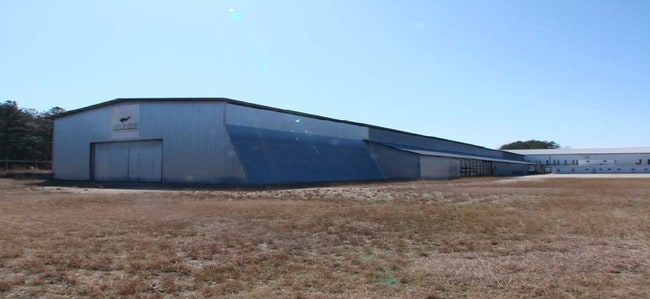

Property Detail
211 N Koppers Rd
00206-01-005
KOPPERS RD
Warehouse
FLORENCE
B and X Area of moderate flood hazard, usually the area between the limits of the 100-year and 500-year floods.
South Carolina
2025
9.27 AC
2025
Other Market Areas
000800
Florence, SC
95,900 SF
NEARBY LISTINGS FOR SALE OR LEASE
-
-
View all Florence listings for sale on LoopNet.com
DEMOGRAPHICS near 211 N Koppers Rd
1 mile
3 mile
5 mile
2025 Total Population
800
16,467
48,168
2030 Population
816
16,982
48,920
Pop Growth 2025-2030
+ 2.00%
+ 3.13%
+ 1.56%
Average Age
41
40
40
2025 Total Households
325
6,589
19,700
HH Growth 2025-2030
+ 2.15%
+ 3.29%
+ 1.64%
Median Household Inc
$43,965
$35,954
$49,778
Avg Household Size
2.40
2.40
2.40
2025 Avg HH Vehicles
2.00
2.00
2.00
Median Home Value
$115,254
$109,651
$167,772
Median Year Built
1982
1977
1978
Nearby Places
Map Layers
Map Styles
 Street
 Aerial
Layers
 Traffic
 Biking
Places
Listings with unknown addresses are not visible on the map
- Restaurants
- Banks
- Shops
- Fitness
- Groceries
PUBLIC TRANSPORTATION
COMMUTER RAIL
Florence Amtrak Station (Palmetto - Amtrak, Silver Meteor - Amtrak)
Drive
Walk
Distance
Florence Amtrak Station (Palmetto - Amtrak, Silver Meteor - Amtrak)
6 min
2.8 mi
Freight Ports
North Charleston Terminal
Drive
Walk
Distance
North Charleston Terminal
147 min
105.7 mi
Nearby Properties
Address
Land Use
TOTAL SIZE
Lot Size
Zoning
Address
Land Use
TOTAL SIZE
Lot Size
Zoning
4,550 SF
275.48 AC
Address
Land Use
TOTAL SIZE
Lot Size
Zoning
8,416 SF
2.10 AC
B4
Address
Land Use
TOTAL SIZE
Lot Size
Zoning
125,000 SF
6.84 AC
B1
Address
Land Use
TOTAL SIZE
Lot Size
Zoning
1,347.68 AC
Address
Land Use
TOTAL SIZE
Lot Size
Zoning
86,950 SF
6.82 AC
B2
Address
Land Use
TOTAL SIZE
Lot Size
Zoning
66,715 SF
0.52 AC
Address
Land Use
TOTAL SIZE
Lot Size
Zoning
Address
Land Use
TOTAL SIZE
Lot Size
Zoning
19,617 SF
0.31 AC
B2
Address
Land Use
TOTAL SIZE
Lot Size
Zoning
133,616 SF
10.98 AC
Address
Land Use
TOTAL SIZE
Lot Size
Zoning
26.36 AC
B1
Address
Land Use
TOTAL SIZE
Lot Size
Zoning
79,263 SF
1.34 AC
B4
Address
Land Use
TOTAL SIZE
Lot Size
Zoning
Address
Land Use
TOTAL SIZE
Lot Size
Zoning
71,400 SF
3.71 AC
B3
Address
Land Use
TOTAL SIZE
Lot Size
Zoning
14,820 SF
0.88 AC
B3
Address
Land Use
TOTAL SIZE
Lot Size
Zoning
47,600 SF
4.57 AC
R4
Address
Land Use
TOTAL SIZE
Lot Size
Zoning
2.39 AC
B1
Address
Land Use
TOTAL SIZE
Lot Size
Zoning
218,850 SF
7.54 AC
B3
Address
Land Use
TOTAL SIZE
Lot Size
Zoning
64,416 SF
3.29 AC
B4
Address
Land Use
TOTAL SIZE
Lot Size
Zoning
12,582 SF
11.23 AC
B3
Address
Land Use
TOTAL SIZE
Lot Size
Zoning
18,908 SF
0.47 AC
B3
Address
Land Use
TOTAL SIZE
Lot Size
Zoning
22,242 SF
0.15 AC
B4
Address
Land Use
TOTAL SIZE
Lot Size
Zoning
10,008 SF
20.91 AC
Address
Land Use
TOTAL SIZE
Lot Size
Zoning
19,336 SF
0.23 AC
B4
Address
Land Use
TOTAL SIZE
Lot Size
Zoning
21,963 SF
0.35 AC
B3
Address
Land Use
TOTAL SIZE
Lot Size
Zoning
28,125 SF
0.27 AC
B4
Address
Land Use
TOTAL SIZE
Lot Size
Zoning
77,515 SF
17.19 AC
Address
Land Use
TOTAL SIZE
Lot Size
Zoning
19,068 SF
0.26 AC
B3
Address
Land Use
TOTAL SIZE
Lot Size
Zoning
32,800 SF
1.89 AC
B1
Address
Land Use
TOTAL SIZE
Lot Size
Zoning
31,868 SF
0.54 AC
B4
The World's #1 Commercial Real Estate Marketplace
Connect with us
© 2026 CoStar Group
The information above has been obtained from sources believed reliable. While we do not doubt its accuracy we have not verified it and make no guarantee, warranty or representation about it. It is your responsibility to independently confirm its accuracy and completeness. Any projections, opinions, assumptions, or estimates used are for example only and do not represent the current or future performance of the property. The value of this transaction to you depends on tax and other factors which should be evaluated by your tax, financial, and legal advisors. You and your advisors should conduct a careful, independent investigation of the property to determine to your satisfaction the suitability of the property for your needs.