Property Record
211 N Main St, Mullica Hill, NJ 08062
NEARBY LISTINGS FOR SALE OR LEASE
-
-
View all Mullica Hill listings for sale on LoopNet.com
Property Detail
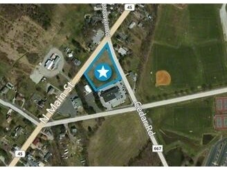
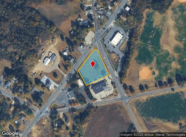
211 N Main St
Philadelphia-Camden-Wilmington, PA-NJ-DE-MD
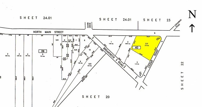
ADDITIONAL LOTS: PROPOSED BANK SITE
08-00040-0000-00002-01
Gloucester
Servicestation
New Jersey
X
2.1
34015C0089E
1.36 AC
2024
Gloucester County
2025
Philadelphia
502002
DEMOGRAPHICS near 211 N Main St
1 Mile
3 Mile
5 Mile
2024 Total Population
1,891
22,593
69,381
2029 Population
1,941
23,229
71,577
Pop Growth 2024-2029
+ 2.64%
+ 2.82%
+ 3.17%
Average Age
39
39
41
2024 Total Households
613
7,840
25,348
HH Growth 2024-2029
+ 2.77%
+ 2.91%
+ 3.27%
Median Household Inc
$148,155
$128,928
$111,682
Avg Household Size
3.00
2.80
2.70
2024 Avg HH Vehicles
2.00
2.00
2.00
Median Home Value
$414,622
$388,439
$329,658
Median Year Built
1992
1993
1984
Nearby Places
Map Layers
Map Styles
 Street
 Aerial
- Restaurants
- Banks
- Shops
- Fitness
- Groceries
PUBLIC TRANSPORTATION
AIRPORT
Philadelphia International
DRIVE
WALK
Distance
Philadelphia International
36 min
22.1 mi
Atlantic City International
DRIVE
WALK
Distance
Atlantic City International
84 min
47.7 mi
Freight Ports
Broadway Terminal - Pier 5
DRIVE
WALK
Distance
Broadway Terminal - Pier 5
23 min
12.3 mi
SALE & LEASE HISTORY
LISTING DATE
SALE/LEASE

Sep 24, 2016
For Sale
Nearby Properties
Address
Land Use
TOTAL SIZE
Lot Size
Zoning
Address
Land Use
TOTAL SIZE
Lot Size
Zoning
80.26 AC
INS
Address
Land Use
TOTAL SIZE
Lot Size
Zoning
13.76 AC
INS
Address
Land Use
TOTAL SIZE
Lot Size
Zoning
14.14 AC
R11
Address
Land Use
TOTAL SIZE
Lot Size
Zoning
12.73 AC
Address
Land Use
TOTAL SIZE
Lot Size
Zoning
24.79 AC
R1
Address
Land Use
TOTAL SIZE
Lot Size
Zoning
Address
Land Use
TOTAL SIZE
Lot Size
Zoning
10.21 AC
RRC
Address
Land Use
TOTAL SIZE
Lot Size
Zoning
5,893 SF
12.79 AC
INSH
Address
Land Use
TOTAL SIZE
Lot Size
Zoning
7.85 AC
R12
Address
Land Use
TOTAL SIZE
Lot Size
Zoning
13.20 AC
INS
Address
Land Use
TOTAL SIZE
Lot Size
Zoning
3.79 AC
PRC
Address
Land Use
TOTAL SIZE
Lot Size
Zoning
5.15 AC
C1
Address
Land Use
TOTAL SIZE
Lot Size
Zoning
3.90 AC
INS
Address
Land Use
TOTAL SIZE
Lot Size
Zoning
19.15 AC
INS
Address
Land Use
TOTAL SIZE
Lot Size
Zoning
Address
Land Use
TOTAL SIZE
Lot Size
Zoning
5 AC
AR
Address
Land Use
TOTAL SIZE
Lot Size
Zoning
8 AC
C2
Address
Land Use
TOTAL SIZE
Lot Size
Zoning
4.38 AC
CC
Address
Land Use
TOTAL SIZE
Lot Size
Zoning
4.73 AC
R1
Address
Land Use
TOTAL SIZE
Lot Size
Zoning
2,984 SF
5.27 AC
R1
Address
Land Use
TOTAL SIZE
Lot Size
Zoning
9.59 AC
INS
Address
Land Use
TOTAL SIZE
Lot Size
Zoning
5.39 AC
C2
Address
Land Use
TOTAL SIZE
Lot Size
Zoning
6.16 AC
AR
Address
Land Use
TOTAL SIZE
Lot Size
Zoning
0.57 AC
C2
Address
Land Use
TOTAL SIZE
Lot Size
Zoning
5.40 AC
PRC
Address
Land Use
TOTAL SIZE
Lot Size
Zoning
7.02 AC
C55
Address
Land Use
TOTAL SIZE
Lot Size
Zoning
10,112 SF
1.13 AC
C2
Address
Land Use
TOTAL SIZE
Lot Size
Zoning
12,040 SF
3.01 AC
Address
Land Use
TOTAL SIZE
Lot Size
Zoning
10,617 SF
17.22 AC
R1
Address
Land Use
TOTAL SIZE
Lot Size
Zoning
The World's #1 Commercial Real Estate Marketplace
Connect with us
© 2025 CoStar Group
The information above has been obtained from sources believed reliable. While we do not doubt its accuracy we have not verified it and make no guarantee, warranty or representation about it. It is your responsibility to independently confirm its accuracy and completeness. Any projections, opinions, assumptions, or estimates used are for example only and do not represent the current or future performance of the property. The value of this transaction to you depends on tax and other factors which should be evaluated by your tax, financial, and legal advisors. You and your advisors should conduct a careful, independent investigation of the property to determine to your satisfaction the suitability of the property for your needs.