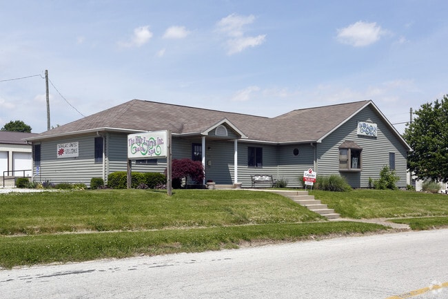
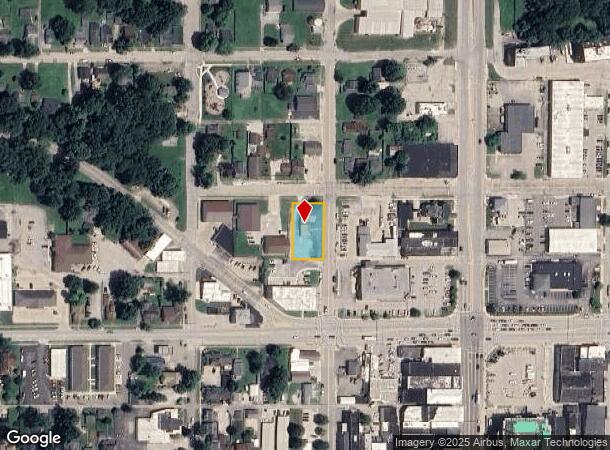
Property Record
211 N Walnut St, Crawfordsville, IN 47933
Current Lease Availabilities
NEARBY LISTINGS FOR SALE OR LEASE
Property Detail
211 N Walnut St
Crawfordsville, IN
City Crawfordsville
54-17-32-223-004.001-030
LOT 26 & PT LOT 25 CRAWFORDSVILLE O P
Storebuilding
Montgomery
X
Indiana
18107C0142C
26,25
2024
0.32 AC
2024
Indiana North Area
957000
Other Market Areas
2,488 SF
DEMOGRAPHICS near 211 N Walnut St
1 Mile
3 Mile
5 Mile
2024 Total Population
9,071
20,742
23,997
2029 Population
9,316
21,251
24,548
Pop Growth 2024-2029
+ 2.70%
+ 2.45%
+ 2.30%
Average Age
38
40
40
2024 Total Households
3,409
8,432
9,719
HH Growth 2024-2029
+ 2.85%
+ 2.51%
+ 2.37%
Median Household Inc
$53,286
$49,380
$52,913
Avg Household Size
2.30
2.30
2.30
2024 Avg HH Vehicles
2.00
2.00
2.00
Median Home Value
$137,435
$143,383
$149,292
Median Year Built
1950
1965
1967
Nearby Places
- Restaurants
- Banks
- Shops
- Fitness
- Groceries
PUBLIC TRANSPORTATION
COMMUTER RAIL
Crawfordsville Amtrak (Cardinal - Amtrak)
DRIVE
WALK
Distance
Crawfordsville Amtrak (Cardinal - Amtrak)
1 min
4 min
0.2 mi
Freight Ports
Port Milwaukee
DRIVE
WALK
Distance
Port Milwaukee
292 min
234.9 mi
Nearby Properties
Address
Land Use
TOTAL SIZE
Lot Size
Zoning
Address
Land Use
TOTAL SIZE
Lot Size
Zoning
384,000 SF
24.02 AC
Address
Land Use
TOTAL SIZE
Lot Size
Zoning
173,932 SF
211.35 AC
Address
Land Use
TOTAL SIZE
Lot Size
Zoning
200,000 SF
27.10 AC
Address
Land Use
TOTAL SIZE
Lot Size
Zoning
230,043 SF
24.25 AC
Address
Land Use
TOTAL SIZE
Lot Size
Zoning
66,013 SF
17.58 AC
Address
Land Use
TOTAL SIZE
Lot Size
Zoning
57,236 SF
18.42 AC
Address
Land Use
TOTAL SIZE
Lot Size
Zoning
104,332 SF
16.56 AC
Address
Land Use
TOTAL SIZE
Lot Size
Zoning
43,444 SF
2.10 AC
Address
Land Use
TOTAL SIZE
Lot Size
Zoning
72,794 SF
1.79 AC
Address
Land Use
TOTAL SIZE
Lot Size
Zoning
46,743 SF
2.17 AC
Address
Land Use
TOTAL SIZE
Lot Size
Zoning
119,472 SF
23.23 AC
Address
Land Use
TOTAL SIZE
Lot Size
Zoning
185,656 SF
8.41 AC
Address
Land Use
TOTAL SIZE
Lot Size
Zoning
31,212 SF
16.80 AC
Address
Land Use
TOTAL SIZE
Lot Size
Zoning
133,107 SF
7.79 AC
Address
Land Use
TOTAL SIZE
Lot Size
Zoning
4,800 SF
3.40 AC
Address
Land Use
TOTAL SIZE
Lot Size
Zoning
12,688 SF
7.38 AC
Address
Land Use
TOTAL SIZE
Lot Size
Zoning
12,688 SF
7.50 AC
Address
Land Use
TOTAL SIZE
Lot Size
Zoning
25,253 SF
4.82 AC
Address
Land Use
TOTAL SIZE
Lot Size
Zoning
23,550 SF
17.38 AC
Address
Land Use
TOTAL SIZE
Lot Size
Zoning
236,167 SF
64.30 AC
Address
Land Use
TOTAL SIZE
Lot Size
Zoning
100,605 SF
8.01 AC
Address
Land Use
TOTAL SIZE
Lot Size
Zoning
22,061 SF
0.42 AC
Address
Land Use
TOTAL SIZE
Lot Size
Zoning
46,724 SF
0.84 AC
Address
Land Use
TOTAL SIZE
Lot Size
Zoning
184,766 SF
22.50 AC
Address
Land Use
TOTAL SIZE
Lot Size
Zoning
182,160 SF
13.57 AC
Address
Land Use
TOTAL SIZE
Lot Size
Zoning
54,501 SF
3.98 AC
Address
Land Use
TOTAL SIZE
Lot Size
Zoning
3,248 SF
2.42 AC
Address
Land Use
TOTAL SIZE
Lot Size
Zoning
166,250 SF
27.65 AC
Address
Land Use
TOTAL SIZE
Lot Size
Zoning
15,955 SF
0.26 AC
Address
Land Use
TOTAL SIZE
Lot Size
Zoning
15,955 SF
0.24 AC
The World's #1 Commercial Real Estate Marketplace
Connect with us
© 2025 CoStar Group
The information above has been obtained from sources believed reliable. While we do not doubt its accuracy we have not verified it and make no guarantee, warranty or representation about it. It is your responsibility to independently confirm its accuracy and completeness. Any projections, opinions, assumptions, or estimates used are for example only and do not represent the current or future performance of the property. The value of this transaction to you depends on tax and other factors which should be evaluated by your tax, financial, and legal advisors. You and your advisors should conduct a careful, independent investigation of the property to determine to your satisfaction the suitability of the property for your needs.