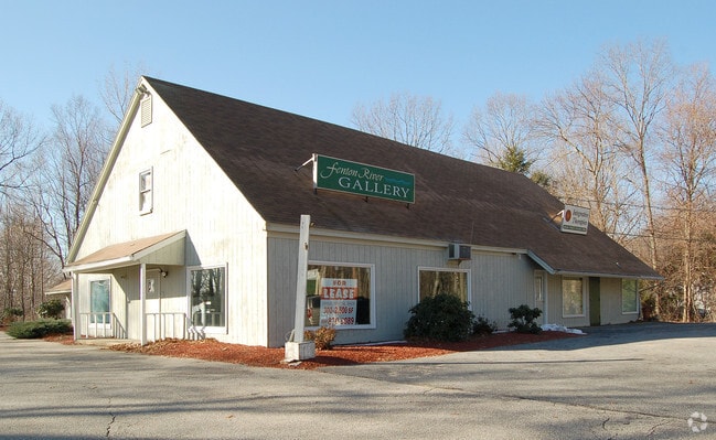
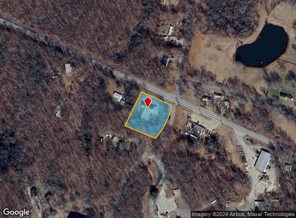
Property Record
211 Nott Hwy, Ashford, CT 06278
NEARBY LISTINGS FOR SALE OR LEASE
-
-
View all Ashford listings for sale on LoopNet.com
Property Detail
211 Nott Hwy
Worcester, MA-CT
Windham
ASHF-000034-F000000-000001
Connecticut
Commercialofficeresidentialmixeduse
1
2025
1.20 AC
2025
Windham County
830100
Hartford
8,400 SF
DEMOGRAPHICS near 211 Nott Hwy
1 Mile
3 Mile
5 Mile
2024 Total Population
179
3,402
19,369
2029 Population
179
3,392
19,207
Pop Growth 2024-2029
0.00%
(0.29%)
(0.84%)
Average Age
43
43
33
2024 Total Households
75
1,455
4,742
HH Growth 2024-2029
0.00%
(0.34%)
(0.84%)
Median Household Inc
$95,833
$78,544
$67,170
Avg Household Size
2.40
2.30
2.30
2024 Avg HH Vehicles
2.00
2.00
2.00
Median Home Value
$309,259
$293,934
$287,404
Median Year Built
1982
1976
1977
Nearby Places
Map Layers
Map Styles
 Street
 Aerial
- Restaurants
- Banks
- Shops
- Fitness
- Groceries
PUBLIC TRANSPORTATION
AIRPORT
Bradley International
DRIVE
WALK
Distance
Bradley International
62 min
36.8 mi
Freight Ports
Port of Davisville, RI
DRIVE
WALK
Distance
Port of Davisville, RI
85 min
57.8 mi
SALE & LEASE HISTORY
LISTING DATE
SALE/LEASE

Sep 24, 2016
For Sale
Nearby Properties
Address
Land Use
TOTAL SIZE
Lot Size
Zoning
Address
Land Use
TOTAL SIZE
Lot Size
Zoning
83,021 SF
9.31 AC
RA
Address
Land Use
TOTAL SIZE
Lot Size
Zoning
1,800 SF
242.90 AC
RA
Address
Land Use
TOTAL SIZE
Lot Size
Zoning
43,472 SF
24.34 AC
R80
Address
Land Use
TOTAL SIZE
Lot Size
Zoning
936 SF
958.54 AC
RA
Address
Land Use
TOTAL SIZE
Lot Size
Zoning
41.50 AC
C
Address
Land Use
TOTAL SIZE
Lot Size
Zoning
25.77 AC
C
Address
Land Use
TOTAL SIZE
Lot Size
Zoning
19.37 AC
C
Address
Land Use
TOTAL SIZE
Lot Size
Zoning
48,960 SF
11.60 AC
RA
Address
Land Use
TOTAL SIZE
Lot Size
Zoning
754 SF
11 AC
C
Address
Land Use
TOTAL SIZE
Lot Size
Zoning
26,000 SF
6.40 AC
C
Address
Land Use
TOTAL SIZE
Lot Size
Zoning
22,133 SF
Address
Land Use
TOTAL SIZE
Lot Size
Zoning
7,900 SF
18.36 AC
R80
Address
Land Use
TOTAL SIZE
Lot Size
Zoning
34.47 AC
RA
Address
Land Use
TOTAL SIZE
Lot Size
Zoning
8,927 SF
1.91 AC
C
Address
Land Use
TOTAL SIZE
Lot Size
Zoning
2.49 AC
RA
Address
Land Use
TOTAL SIZE
Lot Size
Zoning
47.80 AC
RA
Address
Land Use
TOTAL SIZE
Lot Size
Zoning
7,520 SF
2.26 AC
C
Address
Land Use
TOTAL SIZE
Lot Size
Zoning
4,727 SF
1 AC
C
Address
Land Use
TOTAL SIZE
Lot Size
Zoning
11.40 AC
RA
Address
Land Use
TOTAL SIZE
Lot Size
Zoning
9,000 SF
0.81 AC
C
Address
Land Use
TOTAL SIZE
Lot Size
Zoning
4,376 SF
2.11 AC
C
Address
Land Use
TOTAL SIZE
Lot Size
Zoning
19,605 SF
20.49 AC
DC
Address
Land Use
TOTAL SIZE
Lot Size
Zoning
4.60 AC
C
Address
Land Use
TOTAL SIZE
Lot Size
Zoning
3,114 SF
68.61 AC
RAR90
Address
Land Use
TOTAL SIZE
Lot Size
Zoning
5,497 SF
2.92 AC
C
Address
Land Use
TOTAL SIZE
Lot Size
Zoning
3.66 AC
RA
Address
Land Use
TOTAL SIZE
Lot Size
Zoning
2.89 AC
C
Address
Land Use
TOTAL SIZE
Lot Size
Zoning
36.51 AC
RA
Address
Land Use
TOTAL SIZE
Lot Size
Zoning
14,650 SF
2.96 AC
C
Address
Land Use
TOTAL SIZE
Lot Size
Zoning
1.83 AC
RA
The World's #1 Commercial Real Estate Marketplace
Connect with us
© 2025 CoStar Group
The information above has been obtained from sources believed reliable. While we do not doubt its accuracy we have not verified it and make no guarantee, warranty or representation about it. It is your responsibility to independently confirm its accuracy and completeness. Any projections, opinions, assumptions, or estimates used are for example only and do not represent the current or future performance of the property. The value of this transaction to you depends on tax and other factors which should be evaluated by your tax, financial, and legal advisors. You and your advisors should conduct a careful, independent investigation of the property to determine to your satisfaction the suitability of the property for your needs.