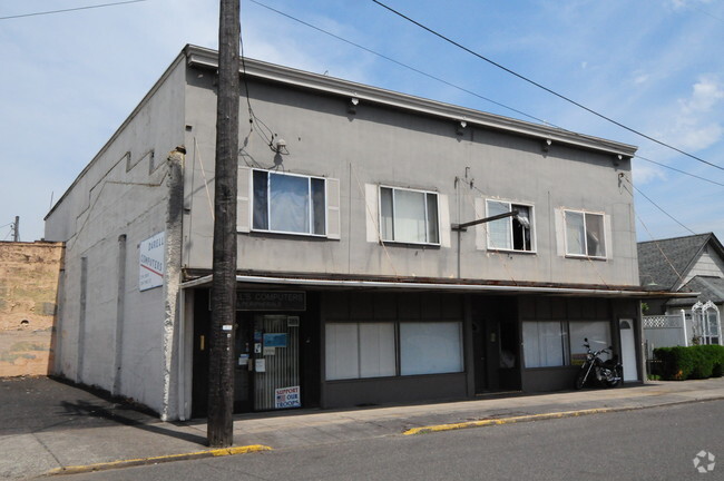
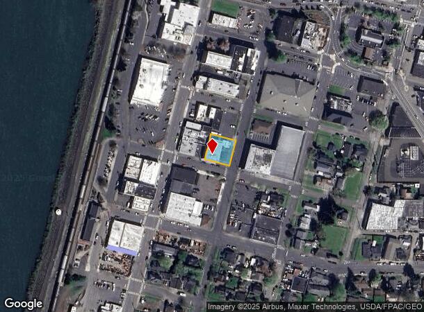
Property Record
211 Pine St, Kelso, WA 98626

Current Lease Availabilities
NEARBY LISTINGS FOR SALE OR LEASE
Property Detail
211 Pine St
Longview-Kelso, WA
Commercial To Kelso
2-1171
146 (COMMERCIAL TO KELSO) -G -9,10 27 -8N -2W
Storebuilding
Cowlitz
X
Washington
53015C0518G
9,10
2025
0.23 AC
2024
Kelso
001000
Portland
4,854 SF
DEMOGRAPHICS near 211 Pine St
1 mile
3 mile
5 mile
2024 Total Population
11,608
50,999
69,217
2029 Population
12,029
52,754
71,650
Pop Growth 2024-2029
+ 3.63%
+ 3.44%
+ 3.52%
Average Age
39
40
41
2024 Total Households
4,648
20,339
27,401
HH Growth 2024-2029
+ 4.09%
+ 3.55%
+ 3.60%
Median Household Inc
$47,669
$58,824
$62,974
Avg Household Size
2.40
2.40
2.50
2024 Avg HH Vehicles
2.00
2.00
2.00
Median Home Value
$230,498
$312,927
$327,118
Median Year Built
1958
1962
1967
Nearby Places
Map Layers
Map Styles
 Street
 Aerial
Transit
 Traffic
 Biking
Places
Listings with unknown addresses are not visible on the map
- Restaurants
- Banks
- Shops
- Fitness
- Groceries
PUBLIC TRANSPORTATION
COMMUTER RAIL
Kelso-Longview (Amtrak Cascades - Amtrak, Coast Starlight - Amtrak)
Drive
Walk
Distance
Kelso-Longview (Amtrak Cascades - Amtrak, Coast Starlight - Amtrak)
0 min
2 min
0.1 mi
Freight Ports
Port of Long View, WA
Drive
Walk
Distance
Port of Long View, WA
11 min
4.3 mi
Nearby Properties
Address
Land Use
TOTAL SIZE
Lot Size
Zoning
Address
Land Use
TOTAL SIZE
Lot Size
Zoning
93.25 AC
MH0
Address
Land Use
TOTAL SIZE
Lot Size
Zoning
83,033 SF
27.78 AC
R01
Address
Land Use
TOTAL SIZE
Lot Size
Zoning
40.70 AC
MH0
Address
Land Use
TOTAL SIZE
Lot Size
Zoning
Address
Land Use
TOTAL SIZE
Lot Size
Zoning
9,600 SF
26.83 AC
MH0
Address
Land Use
TOTAL SIZE
Lot Size
Zoning
40.41 AC
R02
Address
Land Use
TOTAL SIZE
Lot Size
Zoning
10.12 AC
I01
Address
Land Use
TOTAL SIZE
Lot Size
Zoning
139,660 SF
2.76 AC
Address
Land Use
TOTAL SIZE
Lot Size
Zoning
206,926 SF
4.80 AC
C02
Address
Land Use
TOTAL SIZE
Lot Size
Zoning
1 SF
76.14 AC
MH0
Address
Land Use
TOTAL SIZE
Lot Size
Zoning
2.49 AC
Address
Land Use
TOTAL SIZE
Lot Size
Zoning
28.39 AC
M02
Address
Land Use
TOTAL SIZE
Lot Size
Zoning
160,069 SF
20.68 AC
M01
Address
Land Use
TOTAL SIZE
Lot Size
Zoning
25.82 AC
Address
Land Use
TOTAL SIZE
Lot Size
Zoning
106.19 AC
M01
Address
Land Use
TOTAL SIZE
Lot Size
Zoning
48,368 SF
6.32 AC
RF1
Address
Land Use
TOTAL SIZE
Lot Size
Zoning
8.20 AC
C03
Address
Land Use
TOTAL SIZE
Lot Size
Zoning
1 SF
34.61 AC
Address
Land Use
TOTAL SIZE
Lot Size
Zoning
138,715 SF
7.43 AC
C04
Address
Land Use
TOTAL SIZE
Lot Size
Zoning
157,970 SF
12.36 AC
R01
Address
Land Use
TOTAL SIZE
Lot Size
Zoning
50.37 AC
MH0
Address
Land Use
TOTAL SIZE
Lot Size
Zoning
22.50 AC
R01
Address
Land Use
TOTAL SIZE
Lot Size
Zoning
18.59 AC
MH0
Address
Land Use
TOTAL SIZE
Lot Size
Zoning
25.61 AC
R04
Address
Land Use
TOTAL SIZE
Lot Size
Zoning
45,998 SF
1.84 AC
R01
Address
Land Use
TOTAL SIZE
Lot Size
Zoning
129,423 SF
2.34 AC
SR0
Address
Land Use
TOTAL SIZE
Lot Size
Zoning
11.42 AC
Address
Land Use
TOTAL SIZE
Lot Size
Zoning
135,152 SF
0.38 AC
R01
Address
Land Use
TOTAL SIZE
Lot Size
Zoning
193,387 SF
9.65 AC
C03
The World's #1 Commercial Real Estate Marketplace
Connect with us
© 2026 CoStar Group
The information above has been obtained from sources believed reliable. While we do not doubt its accuracy we have not verified it and make no guarantee, warranty or representation about it. It is your responsibility to independently confirm its accuracy and completeness. Any projections, opinions, assumptions, or estimates used are for example only and do not represent the current or future performance of the property. The value of this transaction to you depends on tax and other factors which should be evaluated by your tax, financial, and legal advisors. You and your advisors should conduct a careful, independent investigation of the property to determine to your satisfaction the suitability of the property for your needs.