Property Record
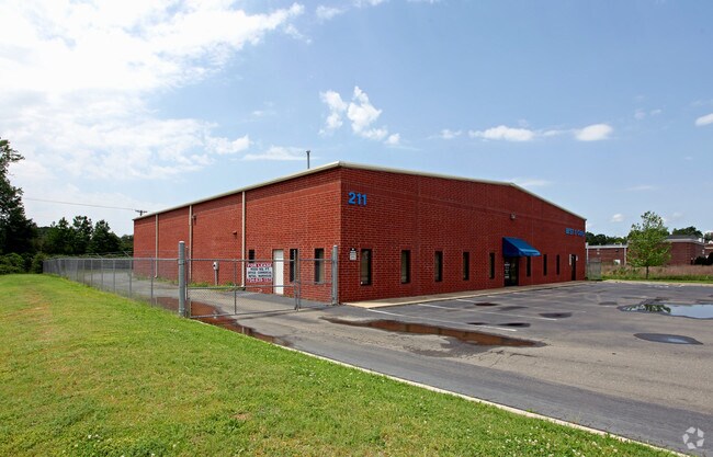
211 Post Office Dr, Indian Trail, NC 28079


NEARBY LISTINGS FOR SALE OR LEASE
Property Detail
211 Post Office Dr
Charlotte-Concord-Gastonia, NC-SC
Indian Trail Bus Park
07-084-593
#17 - 18 IND TRL BUS PARK PH3 OPCM298 POST OFFICE DR
Publicstorage
Union
AE
North Carolina
3710540800J
17
2025
1.68 AC
2025
Union County
020312
Charlotte
9,000 SF
DEMOGRAPHICS near 211 Post Office Dr
1 Mile
3 Mile
5 Mile
2024 Total Population
2,628
43,526
117,759
2029 Population
3,003
48,640
130,040
Pop Growth 2024-2029
+ 14.27%
+ 11.75%
+ 10.43%
Average Age
39
39
40
2024 Total Households
1,008
15,522
41,957
HH Growth 2024-2029
+ 14.48%
+ 12.01%
+ 10.54%
Median Household Inc
$69,617
$81,708
$94,168
Avg Household Size
2.60
2.80
2.80
2024 Avg HH Vehicles
2.00
2.00
2.00
Median Home Value
$257,761
$290,170
$327,944
Median Year Built
1996
1999
2000
Nearby Places
Map Layers
Map Styles
 Street
 Aerial
- Restaurants
- Banks
- Shops
- Fitness
- Groceries
PUBLIC TRANSPORTATION
AIRPORT
Charlotte/Douglas International
DRIVE
WALK
Distance
Charlotte/Douglas International
38 min
23.5 mi
Concord-Padgett Regional
DRIVE
WALK
Distance
Concord-Padgett Regional
36 min
27.4 mi
Nearby Properties
Address
Land Use
TOTAL SIZE
Lot Size
Zoning
Address
Land Use
TOTAL SIZE
Lot Size
Zoning
12.30 AC
SF-1 INDIA
Address
Land Use
TOTAL SIZE
Lot Size
Zoning
282,922 SF
47.76 AC
R4
Address
Land Use
TOTAL SIZE
Lot Size
Zoning
18.05 AC
CBD INDIAN
Address
Land Use
TOTAL SIZE
Lot Size
Zoning
8,446 SF
16.89 AC
MFR INDIAN
Address
Land Use
TOTAL SIZE
Lot Size
Zoning
27,900 SF
15.59 AC
MFR INDIAN
Address
Land Use
TOTAL SIZE
Lot Size
Zoning
227,659 SF
26.46 AC
MFR INDIAN
Address
Land Use
TOTAL SIZE
Lot Size
Zoning
2,062 SF
105.82 AC
B-1SCD
Address
Land Use
TOTAL SIZE
Lot Size
Zoning
498,729 SF
78.21 AC
RBD INDIAN
Address
Land Use
TOTAL SIZE
Lot Size
Zoning
98,929 SF
50.34 AC
SF-1 INDIA
Address
Land Use
TOTAL SIZE
Lot Size
Zoning
49,710 SF
14.20 AC
CZ INDIAN
Address
Land Use
TOTAL SIZE
Lot Size
Zoning
8.82 AC
R-20 STALL
Address
Land Use
TOTAL SIZE
Lot Size
Zoning
75,923 SF
7.29 AC
SF-1 INDIA
Address
Land Use
TOTAL SIZE
Lot Size
Zoning
103,100 SF
28.55 AC
RBD INDIAN
Address
Land Use
TOTAL SIZE
Lot Size
Zoning
93,040 SF
16.57 AC
GR STALLIN
Address
Land Use
TOTAL SIZE
Lot Size
Zoning
209,960 SF
26.64 AC
RBD INDIAN
Address
Land Use
TOTAL SIZE
Lot Size
Zoning
96,456 SF
34.88 AC
R-20 STALL
Address
Land Use
TOTAL SIZE
Lot Size
Zoning
86,960 SF
14.13 AC
SF-1 INDIA
Address
Land Use
TOTAL SIZE
Lot Size
Zoning
45.21 AC
RBD INDIAN
Address
Land Use
TOTAL SIZE
Lot Size
Zoning
232,678 SF
63 AC
RBD INDIAN
Address
Land Use
TOTAL SIZE
Lot Size
Zoning
45,053 SF
15.03 AC
RBD INDIAN
Address
Land Use
TOTAL SIZE
Lot Size
Zoning
69,298 SF
10.29 AC
GBD INDIAN
Address
Land Use
TOTAL SIZE
Lot Size
Zoning
15.33 AC
Address
Land Use
TOTAL SIZE
Lot Size
Zoning
47,362 SF
13.59 AC
NBD INDIAN
Address
Land Use
TOTAL SIZE
Lot Size
Zoning
139,853 SF
16.30 AC
RBD INDIAN
Address
Land Use
TOTAL SIZE
Lot Size
Zoning
52,379 SF
2.11 AC
GBD INDIAN
Address
Land Use
TOTAL SIZE
Lot Size
Zoning
40,680 SF
15.13 AC
Address
Land Use
TOTAL SIZE
Lot Size
Zoning
64,402 SF
43.06 AC
SF-1 INDIA
Address
Land Use
TOTAL SIZE
Lot Size
Zoning
22,429 SF
6.83 AC
R-20 STALL
Address
Land Use
TOTAL SIZE
Lot Size
Zoning
244,087 SF
15.81 AC
CZ STALLIN
Address
Land Use
TOTAL SIZE
Lot Size
Zoning
52,747 SF
8.05 AC
GR STALLIN
The World's #1 Commercial Real Estate Marketplace
Connect with us
© 2026 CoStar Group
The information above has been obtained from sources believed reliable. While we do not doubt its accuracy we have not verified it and make no guarantee, warranty or representation about it. It is your responsibility to independently confirm its accuracy and completeness. Any projections, opinions, assumptions, or estimates used are for example only and do not represent the current or future performance of the property. The value of this transaction to you depends on tax and other factors which should be evaluated by your tax, financial, and legal advisors. You and your advisors should conduct a careful, independent investigation of the property to determine to your satisfaction the suitability of the property for your needs.