Property Record
211 Slater St, Paterson, NJ 07501

Save to a Folder
{{folder.Name}}
{{folder.ListingIds.length}} Properties
{{folder.ListingIds.length}} Property
Create a New Folder
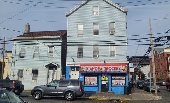
Property Detail
211 Slater St
08-06101-0000-00010
Passaic
Retailwithmorethanonenonretailuse
New Jersey
I-1
10
B and X Area of moderate flood hazard, usually the area between the limits of the 100-year and 500-year floods.
0.12 AC
2025
Passaic Urban Region
2026
Northern New Jersey
182200
New York-Jersey City-White Plains, NY-NJ
5,152 SF
NEARBY LISTINGS FOR SALE OR LEASE
DEMOGRAPHICS near 211 Slater St
1 mile
3 mile
5 mile
2025 Total Population
56,603
272,739
562,660
2030 Population
57,193
275,228
570,961
Pop Growth 2025-2030
+ 1.04%
+ 0.91%
+ 1.48%
Average Age
36
39
39
2025 Total Households
18,578
89,581
189,575
HH Growth 2025-2030
+ 1.23%
+ 0.97%
+ 1.54%
Median Household Inc
$41,772
$71,088
$85,602
Avg Household Size
2.90
2.90
2.80
2025 Avg HH Vehicles
1.00
2.00
2.00
Median Home Value
$313,158
$450,788
$503,655
Median Year Built
1958
1954
1954
Nearby Places
Map Layers
Map Styles
 Street
 Aerial
Layers
 Traffic
 Biking
Places
Listings with unknown addresses are not visible on the map
- Restaurants
- Banks
- Shops
- Fitness
- Groceries
PUBLIC TRANSPORTATION
TRANSIT/SUBWAY
Paterson (Main/Port Jervis Line - NJ Transit Commuter Rail (NJ Transit))
Drive
Walk
Distance
Paterson (Main/Port Jervis Line - NJ Transit Commuter Rail (NJ Transit))
2 min
9 min
0.5 mi
COMMUTER RAIL
Paterson (Main/Port Jervis Line - NJ Transit Commuter Rail (NJ Transit))
Drive
Walk
Distance
Paterson (Main/Port Jervis Line - NJ Transit Commuter Rail (NJ Transit))
2 min
9 min
0.5 mi
Hawthorne (Main/Port Jervis Line - NJ Transit Commuter Rail (NJ Transit))
Drive
Walk
Distance
Hawthorne (Main/Port Jervis Line - NJ Transit Commuter Rail (NJ Transit))
6 min
3.1 mi
AIRPORT
Newark Liberty International
Drive
Walk
Distance
Newark Liberty International
27 min
20.9 mi
LaGuardia
Drive
Walk
Distance
LaGuardia
38 min
25.1 mi
Westchester County
Drive
Walk
Distance
Westchester County
58 min
40.8 mi
Freight Ports
Maher Terminal
Drive
Walk
Distance
Maher Terminal
33 min
20.1 mi
Nearby Properties
Address
Land Use
TOTAL SIZE
Lot Size
Zoning
Address
Land Use
TOTAL SIZE
Lot Size
Zoning
8.75 AC
Address
Land Use
TOTAL SIZE
Lot Size
Zoning
12,506 SF
130 AC
B-2
Address
Land Use
TOTAL SIZE
Lot Size
Zoning
79,310 SF
2 AC
B-2
Address
Land Use
TOTAL SIZE
Lot Size
Zoning
152,050 SF
1.96 AC
B-1
Address
Land Use
TOTAL SIZE
Lot Size
Zoning
26,816 SF
25.50 AC
POP
Address
Land Use
TOTAL SIZE
Lot Size
Zoning
7.83 AC
Address
Land Use
TOTAL SIZE
Lot Size
Zoning
1.80 AC
Address
Land Use
TOTAL SIZE
Lot Size
Zoning
0.69 AC
I-1
Address
Land Use
TOTAL SIZE
Lot Size
Zoning
45,000 SF
124.04 AC
R-A
Address
Land Use
TOTAL SIZE
Lot Size
Zoning
764,364 SF
16.60 AC
I-2
Address
Land Use
TOTAL SIZE
Lot Size
Zoning
0.12 AC
Address
Land Use
TOTAL SIZE
Lot Size
Zoning
11.87 AC
Address
Land Use
TOTAL SIZE
Lot Size
Zoning
183,072 SF
5.50 AC
Address
Land Use
TOTAL SIZE
Lot Size
Zoning
192,252 SF
5 AC
Address
Land Use
TOTAL SIZE
Lot Size
Zoning
140,626 SF
3.28 AC
B-2
Address
Land Use
TOTAL SIZE
Lot Size
Zoning
269,236 SF
10 AC
Address
Land Use
TOTAL SIZE
Lot Size
Zoning
Address
Land Use
TOTAL SIZE
Lot Size
Zoning
7.03 AC
MU
Address
Land Use
TOTAL SIZE
Lot Size
Zoning
1.07 AC
Address
Land Use
TOTAL SIZE
Lot Size
Zoning
3.73 AC
B-2
Address
Land Use
TOTAL SIZE
Lot Size
Zoning
1.20 AC
B-2
Address
Land Use
TOTAL SIZE
Lot Size
Zoning
82,976 SF
0.89 AC
Address
Land Use
TOTAL SIZE
Lot Size
Zoning
48,265 SF
3 AC
R-4
Address
Land Use
TOTAL SIZE
Lot Size
Zoning
1.30 AC
B-2
Address
Land Use
TOTAL SIZE
Lot Size
Zoning
84,845 SF
2.30 AC
B-2
Address
Land Use
TOTAL SIZE
Lot Size
Zoning
63,600 SF
2.46 AC
Address
Land Use
TOTAL SIZE
Lot Size
Zoning
73,052 SF
1.27 AC
B-2
Address
Land Use
TOTAL SIZE
Lot Size
Zoning
7.20 AC
Address
Land Use
TOTAL SIZE
Lot Size
Zoning
2.63 AC
POP
Address
Land Use
TOTAL SIZE
Lot Size
Zoning
271,679 SF
20.79 AC
The World's #1 Commercial Real Estate Marketplace
Connect with us
© 2026 CoStar Group
The information above has been obtained from sources believed reliable. While we do not doubt its accuracy we have not verified it and make no guarantee, warranty or representation about it. It is your responsibility to independently confirm its accuracy and completeness. Any projections, opinions, assumptions, or estimates used are for example only and do not represent the current or future performance of the property. The value of this transaction to you depends on tax and other factors which should be evaluated by your tax, financial, and legal advisors. You and your advisors should conduct a careful, independent investigation of the property to determine to your satisfaction the suitability of the property for your needs.