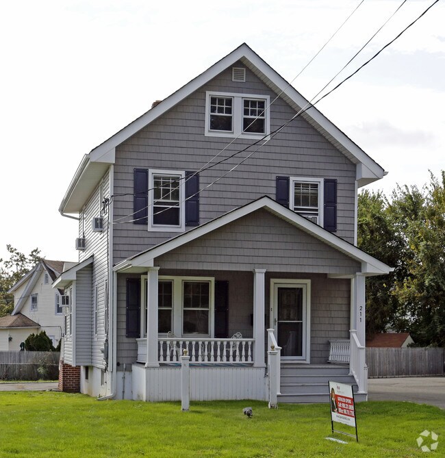
Property Record
211 W End Ave, Raritan, NJ 08869

NEARBY LISTINGS FOR SALE OR LEASE
Property Detail
211 W End Ave
Newark, NJ-PA
Map Of Northwood Section No 1 Of The Cor
16-00030-0000-00007
Somerset
Sfr
New Jersey
X
0.18 AC
34035C0134E
Route 22 West
1,358 SF
Northern New Jersey
DEMOGRAPHICS near 211 W End Ave
1 Mile
3 Mile
5 Mile
2024 Total Population
13,492
62,115
122,415
2029 Population
13,711
62,541
122,591
Pop Growth 2024-2029
+ 1.62%
+ 0.69%
+ 0.14%
Average Age
39
41
42
2024 Total Households
5,594
22,965
45,127
HH Growth 2024-2029
+ 1.75%
+ 0.73%
+ 0.18%
Median Household Inc
$84,874
$113,215
$118,556
Avg Household Size
2.40
2.60
2.60
2024 Avg HH Vehicles
2.00
2.00
2.00
Median Home Value
$370,128
$427,622
$448,538
Median Year Built
1963
1973
1977
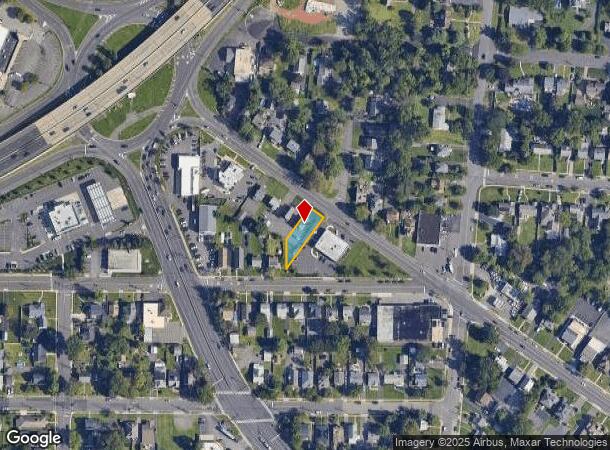
Nearby Places
Map Layers
Map Styles
 Street
 Aerial
- Restaurants
- Banks
- Shops
- Fitness
- Groceries
PUBLIC TRANSPORTATION
COMMUTER RAIL
Raritan (Raritan Valley Line - NJ Transit Commuter Rail (NJ Transit))
DRIVE
WALK
Distance
Raritan (Raritan Valley Line - NJ Transit Commuter Rail (NJ Transit))
3 min
12 min
0.7 mi
Somerville (Raritan Valley Line - NJ Transit Commuter Rail (NJ Transit))
DRIVE
WALK
Distance
Somerville (Raritan Valley Line - NJ Transit Commuter Rail (NJ Transit))
4 min
20 min
1.0 mi
AIRPORT
Trenton Mercer
DRIVE
WALK
Distance
Trenton Mercer
48 min
30.7 mi
Newark Liberty International
DRIVE
WALK
Distance
Newark Liberty International
42 min
34.2 mi
Freight Ports
New York Container Terminal
DRIVE
WALK
Distance
New York Container Terminal
43 min
33.3 mi
SALE & LEASE HISTORY
LISTING DATE
SALE/LEASE

Nov 22, 2019
For Lease
Nov 15, 2019
For Lease
Jan 02, 2019
For Sale
Aug 04, 2017
For Sale
Nearby Properties
Address
Land Use
TOTAL SIZE
Lot Size
Zoning
Address
Land Use
TOTAL SIZE
Lot Size
Zoning
26.42 AC
C2
Address
Land Use
TOTAL SIZE
Lot Size
Zoning
108.74 AC
OM-3
Address
Land Use
TOTAL SIZE
Lot Size
Zoning
13.59 AC
H
Address
Land Use
TOTAL SIZE
Lot Size
Zoning
39.10 AC
C3
Address
Land Use
TOTAL SIZE
Lot Size
Zoning
47.50 AC
M1
Address
Land Use
TOTAL SIZE
Lot Size
Zoning
54.31 AC
P-2
Address
Land Use
TOTAL SIZE
Lot Size
Zoning
153 AC
Address
Land Use
TOTAL SIZE
Lot Size
Zoning
25.70 AC
PACD
Address
Land Use
TOTAL SIZE
Lot Size
Zoning
81.89 AC
M1
Address
Land Use
TOTAL SIZE
Lot Size
Zoning
Address
Land Use
TOTAL SIZE
Lot Size
Zoning
66.08 AC
M3
Address
Land Use
TOTAL SIZE
Lot Size
Zoning
34.80 AC
OM-3
Address
Land Use
TOTAL SIZE
Lot Size
Zoning
82.79 AC
M-2
Address
Land Use
TOTAL SIZE
Lot Size
Zoning
19.34 AC
M1
Address
Land Use
TOTAL SIZE
Lot Size
Zoning
19.36 AC
M1
Address
Land Use
TOTAL SIZE
Lot Size
Zoning
33.16 AC
M3
Address
Land Use
TOTAL SIZE
Lot Size
Zoning
10.31 AC
PDRD
Address
Land Use
TOTAL SIZE
Lot Size
Zoning
5.60 AC
CG
Address
Land Use
TOTAL SIZE
Lot Size
Zoning
8.26 AC
R40
Address
Land Use
TOTAL SIZE
Lot Size
Zoning
1,056 SF
0.07 AC
Address
Land Use
TOTAL SIZE
Lot Size
Zoning
10.47 AC
C2
Address
Land Use
TOTAL SIZE
Lot Size
Zoning
9.91 AC
C2
Address
Land Use
TOTAL SIZE
Lot Size
Zoning
8.60 AC
C2
Address
Land Use
TOTAL SIZE
Lot Size
Zoning
34.26 AC
Address
Land Use
TOTAL SIZE
Lot Size
Zoning
394 SF
36.05 AC
M105
Address
Land Use
TOTAL SIZE
Lot Size
Zoning
43.63 AC
M1B
Address
Land Use
TOTAL SIZE
Lot Size
Zoning
19.95 AC
M1B
Address
Land Use
TOTAL SIZE
Lot Size
Zoning
12.53 AC
M1
Address
Land Use
TOTAL SIZE
Lot Size
Zoning
18.99 AC
M1
Address
Land Use
TOTAL SIZE
Lot Size
Zoning
28.44 AC
C2
The World's #1 Commercial Real Estate Marketplace
Connect with us
© 2025 CoStar Group
The information above has been obtained from sources believed reliable. While we do not doubt its accuracy we have not verified it and make no guarantee, warranty or representation about it. It is your responsibility to independently confirm its accuracy and completeness. Any projections, opinions, assumptions, or estimates used are for example only and do not represent the current or future performance of the property. The value of this transaction to you depends on tax and other factors which should be evaluated by your tax, financial, and legal advisors. You and your advisors should conduct a careful, independent investigation of the property to determine to your satisfaction the suitability of the property for your needs.