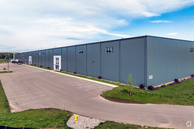
Property Record
211 Watkins Rd, Battle Creek, MI 49015

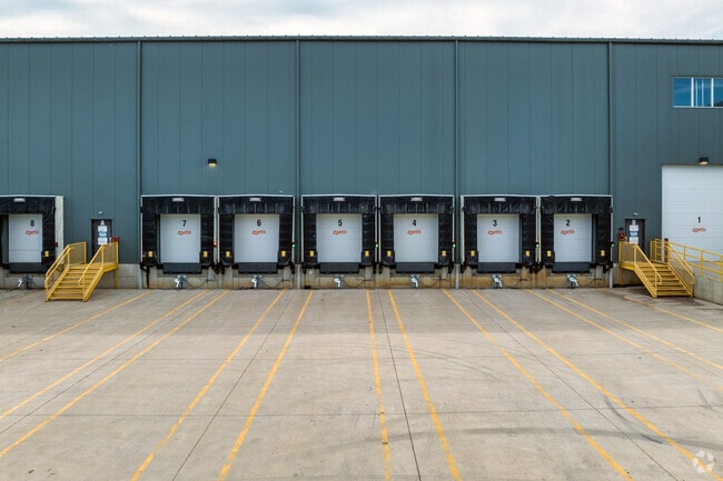
Current Lease Availabilities
NEARBY LISTINGS FOR SALE OR LEASE
Property Detail
211 Watkins Rd
Battle Creek, MI
A PARCEL OF LAND LOCATED IN THE NORTHWEST 1/4 OF SECTION 30, TOWN 2 SOUTH, RANGE 8 WEST, CITY OF BATTLE CREEK, CALHOUN
0630-18-500-0
Calhoun
Manufacturinglight
Michigan
0
24.29 AC
2025
Battle Crk/W Calhoun Cnty
001500
West Michigan
270,000 SF
DEMOGRAPHICS near 211 Watkins Rd
1 Mile
3 Mile
5 Mile
2024 Total Population
209
2,507
22,129
2029 Population
205
2,455
21,764
Pop Growth 2024-2029
(1.91%)
(2.07%)
(1.65%)
Average Age
43
43
41
2024 Total Households
74
930
9,008
HH Growth 2024-2029
(1.35%)
(2.04%)
(1.63%)
Median Household Inc
$107,500
$102,212
$64,191
Avg Household Size
2.70
2.60
2.40
2024 Avg HH Vehicles
2.00
2.00
2.00
Median Home Value
$226,666
$226,539
$166,425
Median Year Built
1992
1990
1966
Nearby Places
Map Layers
Map Styles
 Street
 Aerial
- Restaurants
- Banks
- Shops
- Fitness
- Groceries
PUBLIC TRANSPORTATION
AIRPORT
Kalamazoo/Battle Creek International
DRIVE
WALK
Distance
Kalamazoo/Battle Creek International
30 min
21.9 mi
Freight Ports
Port of Toledo
DRIVE
WALK
Distance
Port of Toledo
155 min
128.3 mi
Nearby Properties
Address
Land Use
TOTAL SIZE
Lot Size
Zoning
Address
Land Use
TOTAL SIZE
Lot Size
Zoning
131,048 SF
12.28 AC
R1A
Address
Land Use
TOTAL SIZE
Lot Size
Zoning
111,002 SF
AG
Address
Land Use
TOTAL SIZE
Lot Size
Zoning
252,000 SF
34.57 AC
I2
Address
Land Use
TOTAL SIZE
Lot Size
Zoning
308,395 SF
24.34 AC
I2
Address
Land Use
TOTAL SIZE
Lot Size
Zoning
94,222 SF
I2
Address
Land Use
TOTAL SIZE
Lot Size
Zoning
95,666 SF
46.56 AC
I1
Address
Land Use
TOTAL SIZE
Lot Size
Zoning
123,918 SF
24.50 AC
I2
Address
Land Use
TOTAL SIZE
Lot Size
Zoning
225,000 SF
21.84 AC
I2
Address
Land Use
TOTAL SIZE
Lot Size
Zoning
145,984 SF
10.93 AC
I2
Address
Land Use
TOTAL SIZE
Lot Size
Zoning
77,948 SF
13.10 AC
I2
Address
Land Use
TOTAL SIZE
Lot Size
Zoning
39,851 SF
8.13 AC
I1
Address
Land Use
TOTAL SIZE
Lot Size
Zoning
2,352 SF
257.14 AC
AG-2
Address
Land Use
TOTAL SIZE
Lot Size
Zoning
90,000 SF
5.51 AC
I2
Address
Land Use
TOTAL SIZE
Lot Size
Zoning
1,890 SF
95.39 AC
AG-1
Address
Land Use
TOTAL SIZE
Lot Size
Zoning
194.96 AC
AG-1
Address
Land Use
TOTAL SIZE
Lot Size
Zoning
1,679 SF
160 AC
A-1
Address
Land Use
TOTAL SIZE
Lot Size
Zoning
2,026 SF
78 AC
A-1
Address
Land Use
TOTAL SIZE
Lot Size
Zoning
170.28 AC
A-1
Address
Land Use
TOTAL SIZE
Lot Size
Zoning
80,700 SF
5.52 AC
I2
Address
Land Use
TOTAL SIZE
Lot Size
Zoning
168.76 AC
A-1
Address
Land Use
TOTAL SIZE
Lot Size
Zoning
20,874 SF
10.70 AC
B1
Address
Land Use
TOTAL SIZE
Lot Size
Zoning
63,400 SF
6.58 AC
I2
Address
Land Use
TOTAL SIZE
Lot Size
Zoning
153.60 AC
A-1
Address
Land Use
TOTAL SIZE
Lot Size
Zoning
156.11 AC
AG
Address
Land Use
TOTAL SIZE
Lot Size
Zoning
30,342 SF
3.70 AC
I2
Address
Land Use
TOTAL SIZE
Lot Size
Zoning
147 AC
A-1
Address
Land Use
TOTAL SIZE
Lot Size
Zoning
5,731 SF
3.20 AC
I2
Address
Land Use
TOTAL SIZE
Lot Size
Zoning
9,308 SF
136.03 AC
AG
Address
Land Use
TOTAL SIZE
Lot Size
Zoning
141.50 AC
AG-1
The World's #1 Commercial Real Estate Marketplace
Connect with us
© 2025 CoStar Group
The information above has been obtained from sources believed reliable. While we do not doubt its accuracy we have not verified it and make no guarantee, warranty or representation about it. It is your responsibility to independently confirm its accuracy and completeness. Any projections, opinions, assumptions, or estimates used are for example only and do not represent the current or future performance of the property. The value of this transaction to you depends on tax and other factors which should be evaluated by your tax, financial, and legal advisors. You and your advisors should conduct a careful, independent investigation of the property to determine to your satisfaction the suitability of the property for your needs.