Property Record
2110 Aviation Way, Carlsbad, NM 88220
NEARBY LISTINGS FOR SALE OR LEASE
Property Detail
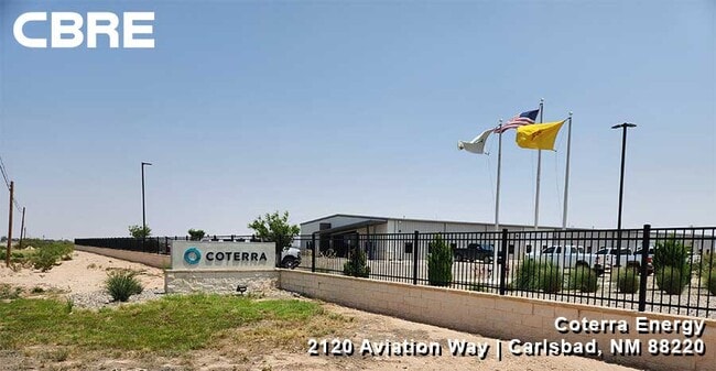
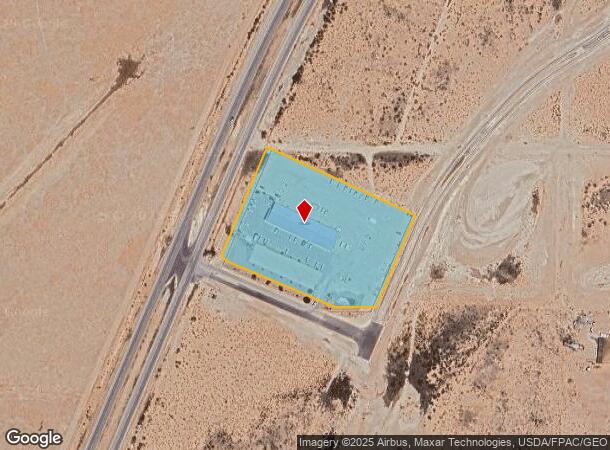
2110 Aviation Way
Carlsbad-Artesia, NM
Carlston Ranch Replat No 2
4-155-133-457-375
SUBD: CARLSTON RANCH REPLAT NO 2 TRACT 35A TRACT: 35A QUARTER: NE S: 2 T: 23S R: 26E
Realpropertynec
Eddy
X
New Mexico
35015C1325D
5.02 AC
2025
New Mexico South Area
2025
Other Market Areas
000700
DEMOGRAPHICS near 2110 Aviation Way
1 Mile
3 Mile
5 Mile
2024 Total Population
172
3,207
11,643
2029 Population
158
3,072
11,496
Pop Growth 2024-2029
(8.14%)
(4.21%)
(1.26%)
Average Age
41
38
37
2024 Total Households
61
1,111
4,008
HH Growth 2024-2029
(8.20%)
(4.32%)
(1.40%)
Median Household Inc
$70,714
$84,105
$72,992
Avg Household Size
2.70
2.80
2.80
2024 Avg HH Vehicles
3.00
3.00
3.00
Median Home Value
$350,000
$156,178
$168,704
Median Year Built
1986
1987
1991
Nearby Places
Map Layers
Map Styles
 Street
 Aerial
- Restaurants
- Banks
- Shops
- Fitness
- Groceries
SALE & LEASE HISTORY
LISTING DATE
SALE/LEASE

Sep 25, 2024
For Sale
Nearby Properties
Address
Land Use
TOTAL SIZE
Lot Size
Zoning
Address
Land Use
TOTAL SIZE
Lot Size
Zoning
526.75 AC
Address
Land Use
TOTAL SIZE
Lot Size
Zoning
8.80 AC
Address
Land Use
TOTAL SIZE
Lot Size
Zoning
Address
Land Use
TOTAL SIZE
Lot Size
Zoning
54.66 AC
Address
Land Use
TOTAL SIZE
Lot Size
Zoning
12.12 AC
Address
Land Use
TOTAL SIZE
Lot Size
Zoning
2.12 AC
Address
Land Use
TOTAL SIZE
Lot Size
Zoning
516 AC
Address
Land Use
TOTAL SIZE
Lot Size
Zoning
Address
Land Use
TOTAL SIZE
Lot Size
Zoning
Address
Land Use
TOTAL SIZE
Lot Size
Zoning
2.39 AC
Address
Land Use
TOTAL SIZE
Lot Size
Zoning
5.17 AC
Address
Land Use
TOTAL SIZE
Lot Size
Zoning
Address
Land Use
TOTAL SIZE
Lot Size
Zoning
Address
Land Use
TOTAL SIZE
Lot Size
Zoning
4.66 AC
Address
Land Use
TOTAL SIZE
Lot Size
Zoning
Address
Land Use
TOTAL SIZE
Lot Size
Zoning
Address
Land Use
TOTAL SIZE
Lot Size
Zoning
Address
Land Use
TOTAL SIZE
Lot Size
Zoning
Address
Land Use
TOTAL SIZE
Lot Size
Zoning
Address
Land Use
TOTAL SIZE
Lot Size
Zoning
1,352 SF
2.49 AC
Address
Land Use
TOTAL SIZE
Lot Size
Zoning
Address
Land Use
TOTAL SIZE
Lot Size
Zoning
Address
Land Use
TOTAL SIZE
Lot Size
Zoning
4.64 AC
Address
Land Use
TOTAL SIZE
Lot Size
Zoning
2.98 AC
Address
Land Use
TOTAL SIZE
Lot Size
Zoning
Address
Land Use
TOTAL SIZE
Lot Size
Zoning
Address
Land Use
TOTAL SIZE
Lot Size
Zoning
Address
Land Use
TOTAL SIZE
Lot Size
Zoning
Address
Land Use
TOTAL SIZE
Lot Size
Zoning
22.07 AC
The World's #1 Commercial Real Estate Marketplace
Connect with us
© 2026 CoStar Group
The information above has been obtained from sources believed reliable. While we do not doubt its accuracy we have not verified it and make no guarantee, warranty or representation about it. It is your responsibility to independently confirm its accuracy and completeness. Any projections, opinions, assumptions, or estimates used are for example only and do not represent the current or future performance of the property. The value of this transaction to you depends on tax and other factors which should be evaluated by your tax, financial, and legal advisors. You and your advisors should conduct a careful, independent investigation of the property to determine to your satisfaction the suitability of the property for your needs.