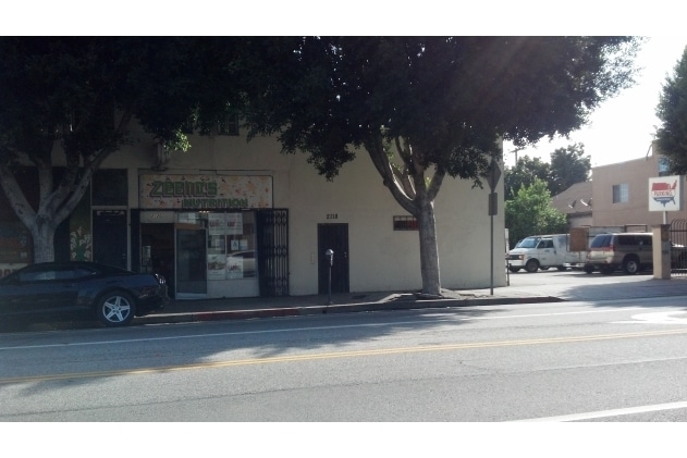
Property Record
2110 E 1St St, Los Angeles, CA 90033


Current Lease Availabilities
NEARBY LISTINGS FOR SALE OR LEASE
Property Detail
2110 E 1St St
Los Angeles-Long Beach-Glendale, CA
Boyle Heights
5183-008-020
BOYLE HEIGHTS NW 20 FT OF LOTS 6 AND ALL OF LOT 8 BLK I
Storemultistory
Los Angeles
X
California
06037C1637F
6,8
2024
0.27 AC
2025
Southeast Los Angeles
203602
Los Angeles
1,320 SF
DEMOGRAPHICS near 2110 E 1St St
1 Mile
3 Mile
5 Mile
2024 Total Population
47,210
300,286
935,932
2029 Population
45,447
291,145
900,283
Pop Growth 2024-2029
(3.73%)
(3.04%)
(3.81%)
Average Age
37
38
38
2024 Total Households
13,424
104,208
309,626
HH Growth 2024-2029
(4.07%)
(2.62%)
(3.64%)
Median Household Inc
$51,845
$56,351
$55,427
Avg Household Size
3.30
2.60
2.80
2024 Avg HH Vehicles
2.00
1.00
1.00
Median Home Value
$644,971
$701,485
$735,934
Median Year Built
1949
1963
1957
Nearby Places
Map Layers
Map Styles
 Street
 Aerial
- Restaurants
- Banks
- Shops
- Fitness
- Groceries
PUBLIC TRANSPORTATION
TRANSIT/SUBWAY
Soto (Gold Line - Los Angeles County Metropolitan Transportation Authority (Metro))
DRIVE
WALK
Distance
Soto (Gold Line - Los Angeles County Metropolitan Transportation Authority (Metro))
1 min
4 min
0.2 mi
Mariachi Plaza (Gold Line - Los Angeles County Metropolitan Transportation Authority (Metro))
DRIVE
WALK
Distance
Mariachi Plaza (Gold Line - Los Angeles County Metropolitan Transportation Authority (Metro))
1 min
8 min
0.4 mi
Pico-Aliso (Gold Line - Los Angeles County Metropolitan Transportation Authority (Metro))
DRIVE
WALK
Distance
Pico-Aliso (Gold Line - Los Angeles County Metropolitan Transportation Authority (Metro))
2 min
16 min
0.8 mi
COMMUTER RAIL
DRIVE
WALK
Distance
4 min
1.9 mi
Union Station (91 Line - Southern California Regional Rail Authority (Metrolink), Antelope Valley Line - Southern California Regional Rail Authority (Metrolink), Orange County Line - Southern California Regional Rail Authority (Metrolink), Riverside Line - Southern California Regional Rail Authority (Metrolink), San Bernardino Line - Southern California Regional Rail Authority (Metrolink), Ventura County Line - Southern California Regional Rail Authority (Metrolink))
DRIVE
WALK
Distance
Union Station (91 Line - Southern California Regional Rail Authority (Metrolink), Antelope Valley Line - Southern California Regional Rail Authority (Metrolink), Orange County Line - Southern California Regional Rail Authority (Metrolink), Riverside Line - Southern California Regional Rail Authority (Metrolink), San Bernardino Line - Southern California Regional Rail Authority (Metrolink), Ventura County Line - Southern California Regional Rail Authority (Metrolink))
7 min
2.0 mi
AIRPORT
Bob Hope
DRIVE
WALK
Distance
Bob Hope
24 min
17.2 mi
Los Angeles International
DRIVE
WALK
Distance
Los Angeles International
29 min
18.0 mi
Long Beach (Daugherty Field)
DRIVE
WALK
Distance
Long Beach (Daugherty Field)
31 min
20.5 mi
Freight Ports
Port of Long Beach
DRIVE
WALK
Distance
Port of Long Beach
32 min
23.4 mi
Nearby Properties
Address
Land Use
TOTAL SIZE
Lot Size
Zoning
Address
Land Use
TOTAL SIZE
Lot Size
Zoning
2,832,748 SF
4.20 AC
LAC2
Address
Land Use
TOTAL SIZE
Lot Size
Zoning
1,392,719 SF
4.22 AC
LAC4
Address
Land Use
TOTAL SIZE
Lot Size
Zoning
2,001,034 SF
2.71 AC
LAC2
Address
Land Use
TOTAL SIZE
Lot Size
Zoning
969,264 SF
0.94 AC
LAC2
Address
Land Use
TOTAL SIZE
Lot Size
Zoning
717,065 SF
0.99 AC
LAC2
Address
Land Use
TOTAL SIZE
Lot Size
Zoning
1,039,642 SF
2.84 AC
LAC2
Address
Land Use
TOTAL SIZE
Lot Size
Zoning
1,486,375 SF
3.77 AC
LAR5
Address
Land Use
TOTAL SIZE
Lot Size
Zoning
1,457,208 SF
1.39 AC
LAC2
Address
Land Use
TOTAL SIZE
Lot Size
Zoning
949,529 SF
1.50 AC
LAC2
Address
Land Use
TOTAL SIZE
Lot Size
Zoning
200,811 SF
4.59 AC
LALASED
Address
Land Use
TOTAL SIZE
Lot Size
Zoning
764,804 SF
1.48 AC
Address
Land Use
TOTAL SIZE
Lot Size
Zoning
634,863 SF
2.97 AC
LAC2-4D
Address
Land Use
TOTAL SIZE
Lot Size
Zoning
1,346,113 SF
1.17 AC
LAC5
Address
Land Use
TOTAL SIZE
Lot Size
Zoning
738,975 SF
2.71 AC
LAC2
Address
Land Use
TOTAL SIZE
Lot Size
Zoning
1,094,768 SF
0.73 AC
LAC2
Address
Land Use
TOTAL SIZE
Lot Size
Zoning
574,047 SF
1.70 AC
LAR5
Address
Land Use
TOTAL SIZE
Lot Size
Zoning
705,234 SF
1.83 AC
LAC2
Address
Land Use
TOTAL SIZE
Lot Size
Zoning
966,466 SF
3.99 AC
LAC2
Address
Land Use
TOTAL SIZE
Lot Size
Zoning
816,046 SF
15.37 AC
LAA1
Address
Land Use
TOTAL SIZE
Lot Size
Zoning
773,409 SF
1.39 AC
LAC4
Address
Land Use
TOTAL SIZE
Lot Size
Zoning
1,005,477 SF
1.36 AC
LAC4
Address
Land Use
TOTAL SIZE
Lot Size
Zoning
2,697,158 SF
20.18 AC
LAM2
Address
Land Use
TOTAL SIZE
Lot Size
Zoning
581,956 SF
0.89 AC
LAR5
Address
Land Use
TOTAL SIZE
Lot Size
Zoning
1,207,589 SF
1.01 AC
LAC2
Address
Land Use
TOTAL SIZE
Lot Size
Zoning
651,289 SF
3.79 AC
LACW
Address
Land Use
TOTAL SIZE
Lot Size
Zoning
1.28 AC
LAC2
Address
Land Use
TOTAL SIZE
Lot Size
Zoning
387,421 SF
1.08 AC
LAR5
Address
Land Use
TOTAL SIZE
Lot Size
Zoning
465,722 SF
5.84 AC
LAC4
Address
Land Use
TOTAL SIZE
Lot Size
Zoning
195,675 SF
LAC2
Address
Land Use
TOTAL SIZE
Lot Size
Zoning
635,233 SF
12.02 AC
LAR5
The World's #1 Commercial Real Estate Marketplace
Connect with us
© 2025 CoStar Group
The information above has been obtained from sources believed reliable. While we do not doubt its accuracy we have not verified it and make no guarantee, warranty or representation about it. It is your responsibility to independently confirm its accuracy and completeness. Any projections, opinions, assumptions, or estimates used are for example only and do not represent the current or future performance of the property. The value of this transaction to you depends on tax and other factors which should be evaluated by your tax, financial, and legal advisors. You and your advisors should conduct a careful, independent investigation of the property to determine to your satisfaction the suitability of the property for your needs.