Property Record
2110 E Laburnum Ave, Richmond, VA 23222


NEARBY LISTINGS FOR SALE OR LEASE
Property Detail
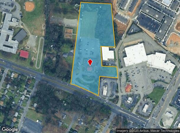
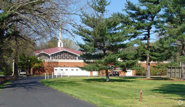
2110 E Laburnum Ave
802-736-2852
01180A0000 0063; ADAMS / LABURNUM AC 7.58 2 A2 28
Funeralhome
Henrico
X
Virginia
5101290035E
7.58 AC
2025
Laburnum/Rte 360
2025
Richmond VA
201001
Richmond, VA
14,296 SF
DEMOGRAPHICS near 2110 E Laburnum Ave
1 Mile
3 Mile
5 Mile
2024 Total Population
8,861
78,540
226,670
2029 Population
8,868
80,880
233,801
Pop Growth 2024-2029
+ 0.08%
+ 2.98%
+ 3.15%
Average Age
42
39
39
2024 Total Households
3,586
32,666
102,648
HH Growth 2024-2029
+ 0.03%
+ 2.93%
+ 3.27%
Median Household Inc
$59,113
$45,616
$54,891
Avg Household Size
2.40
2.30
2.10
2024 Avg HH Vehicles
2.00
2.00
2.00
Median Home Value
$164,703
$222,023
$254,192
Median Year Built
1961
1968
1966
Nearby Places
Map Layers
Map Styles
 Street
 Aerial
- Restaurants
- Banks
- Shops
- Fitness
- Groceries
PUBLIC TRANSPORTATION
COMMUTER RAIL
Richmond Main Street Amtrak Station (Northeast Regional - Amtrak)
DRIVE
WALK
Distance
Richmond Main Street Amtrak Station (Northeast Regional - Amtrak)
8 min
4.7 mi
Richmond Staples Mill Road Amtrak Station (Carolinian - Amtrak, Northeast Regional - Amtrak, Palmetto - Amtrak, Silver Meteor - Amtrak)
DRIVE
WALK
Distance
Richmond Staples Mill Road Amtrak Station (Carolinian - Amtrak, Northeast Regional - Amtrak, Palmetto - Amtrak, Silver Meteor - Amtrak)
13 min
7.2 mi
AIRPORT
Richmond International
DRIVE
WALK
Distance
Richmond International
15 min
8.2 mi
Freight Ports
Virginia Port Authority - Richmond
DRIVE
WALK
Distance
Virginia Port Authority - Richmond
19 min
10.9 mi
Nearby Properties
Address
Land Use
TOTAL SIZE
Lot Size
Zoning
Address
Land Use
TOTAL SIZE
Lot Size
Zoning
2,645,407 SF
116.30 AC
M2-C
Address
Land Use
TOTAL SIZE
Lot Size
Zoning
286,180 SF
8.78 AC
R-03 RESID
Address
Land Use
TOTAL SIZE
Lot Size
Zoning
11.17 AC
M-2 HEAVY
Address
Land Use
TOTAL SIZE
Lot Size
Zoning
281,456 SF
84.22 AC
R-5
Address
Land Use
TOTAL SIZE
Lot Size
Zoning
14.89 AC
R-53 MULTI
Address
Land Use
TOTAL SIZE
Lot Size
Zoning
111,948 SF
2.64 AC
RP REASEAR
Address
Land Use
TOTAL SIZE
Lot Size
Zoning
59,574 SF
313.03 AC
MIXE
Address
Land Use
TOTAL SIZE
Lot Size
Zoning
363,462 SF
11.01 AC
MULTIPLE Z
Address
Land Use
TOTAL SIZE
Lot Size
Zoning
228,297 SF
15.79 AC
M-1 LIGHT
Address
Land Use
TOTAL SIZE
Lot Size
Zoning
179,827 SF
2.18 AC
R-03 RESID
Address
Land Use
TOTAL SIZE
Lot Size
Zoning
273,822 SF
22.74 AC
R-5
Address
Land Use
TOTAL SIZE
Lot Size
Zoning
216,680 SF
4.45 AC
M-1 LIGHT
Address
Land Use
TOTAL SIZE
Lot Size
Zoning
110,790 SF
37.61 AC
R-2A
Address
Land Use
TOTAL SIZE
Lot Size
Zoning
292,981 SF
3.79 AC
MULTIPLE Z
Address
Land Use
TOTAL SIZE
Lot Size
Zoning
100 SF
11.56 AC
R-53 MULTI
Address
Land Use
TOTAL SIZE
Lot Size
Zoning
331,455 SF
12.75 AC
UMUC
Address
Land Use
TOTAL SIZE
Lot Size
Zoning
115,961 SF
2.35 AC
RP REASEAR
Address
Land Use
TOTAL SIZE
Lot Size
Zoning
432,000 SF
4.68 AC
R-53 MULTI
Address
Land Use
TOTAL SIZE
Lot Size
Zoning
328,080 SF
2.96 AC
RP REASEAR
Address
Land Use
TOTAL SIZE
Lot Size
Zoning
69,297 SF
49.66 AC
A-1
Address
Land Use
TOTAL SIZE
Lot Size
Zoning
114,056 SF
0.36 AC
M-1 LIGHT
Address
Land Use
TOTAL SIZE
Lot Size
Zoning
Address
Land Use
TOTAL SIZE
Lot Size
Zoning
235,336 SF
18.67 AC
MIXE
Address
Land Use
TOTAL SIZE
Lot Size
Zoning
140,272 SF
17.85 AC
R-5
Address
Land Use
TOTAL SIZE
Lot Size
Zoning
228,744 SF
21.11 AC
R-5
Address
Land Use
TOTAL SIZE
Lot Size
Zoning
227,008 SF
20.94 AC
R-5
Address
Land Use
TOTAL SIZE
Lot Size
Zoning
152,064 SF
34.67 AC
R-53 MULTI
Address
Land Use
TOTAL SIZE
Lot Size
Zoning
182,280 SF
33.19 AC
MULTIPLE Z
Address
Land Use
TOTAL SIZE
Lot Size
Zoning
44,891 SF
8.88 AC
R-TH
Address
Land Use
TOTAL SIZE
Lot Size
Zoning
127,520 SF
13.50 AC
R-5
The World's #1 Commercial Real Estate Marketplace
Connect with us
© 2025 CoStar Group
The information above has been obtained from sources believed reliable. While we do not doubt its accuracy we have not verified it and make no guarantee, warranty or representation about it. It is your responsibility to independently confirm its accuracy and completeness. Any projections, opinions, assumptions, or estimates used are for example only and do not represent the current or future performance of the property. The value of this transaction to you depends on tax and other factors which should be evaluated by your tax, financial, and legal advisors. You and your advisors should conduct a careful, independent investigation of the property to determine to your satisfaction the suitability of the property for your needs.