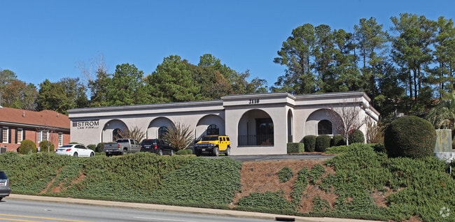
Property Record
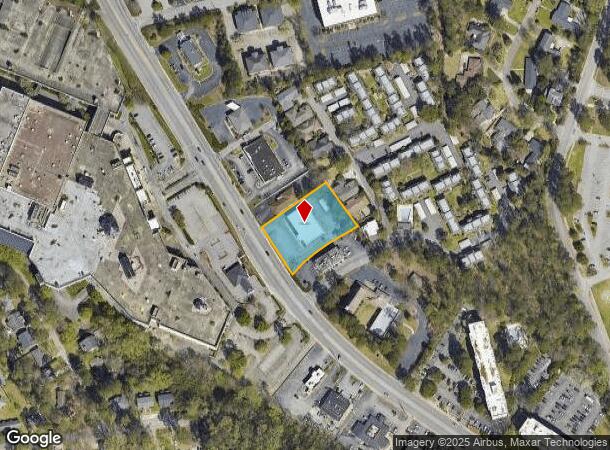
2110 N Beltline Blvd, Columbia, SC 29204
NEARBY LISTINGS FOR SALE OR LEASE
Property Detail
2110 N Beltline Blvd
13908-05-02
Forest Acres
Commercialnec
181.8X249.6X130.2X43.9X38.8X 52.9X61.8X50.7X60 #SU
X
Richland
45079C0263L
South Carolina
2025
0.96 AC
2024
Forest Acres
011201
Columbia
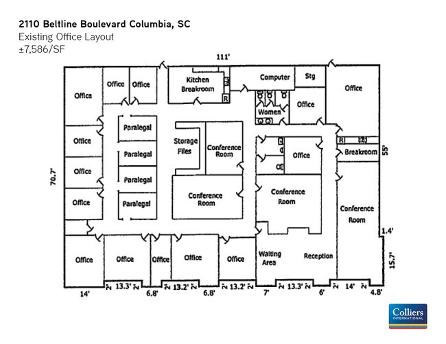
7,822 SF
Columbia, SC
DEMOGRAPHICS near 2110 N Beltline Blvd
1 Mile
3 Mile
5 Mile
2024 Total Population
9,041
84,298
173,818
2029 Population
9,203
85,744
177,872
Pop Growth 2024-2029
+ 1.79%
+ 1.72%
+ 2.33%
Average Age
42
37
36
2024 Total Households
4,351
34,181
72,227
HH Growth 2024-2029
+ 1.95%
+ 1.86%
+ 2.55%
Median Household Inc
$74,396
$49,609
$45,619
Avg Household Size
2.10
2.00
2.10
2024 Avg HH Vehicles
2.00
2.00
2.00
Median Home Value
$288,999
$253,634
$203,610
Median Year Built
1959
1962
1970
Nearby Places
Map Layers
Map Styles
 Street
 Aerial
- Restaurants
- Banks
- Shops
- Fitness
- Groceries
PUBLIC TRANSPORTATION
COMMUTER RAIL
DRIVE
WALK
Distance
11 min
4.5 mi
AIRPORT
Columbia Metro
DRIVE
WALK
Distance
Columbia Metro
29 min
14.0 mi
SALE & LEASE HISTORY
LISTING DATE
SALE/LEASE

Jun 12, 2020
For Lease
Nearby Properties
Address
Land Use
TOTAL SIZE
Lot Size
Zoning
Address
Land Use
TOTAL SIZE
Lot Size
Zoning
501,365 SF
13.28 AC
O-I
Address
Land Use
TOTAL SIZE
Lot Size
Zoning
106,284 SF
10.83 AC
C-5
Address
Land Use
TOTAL SIZE
Lot Size
Zoning
100 SF
15.17 AC
C-1
Address
Land Use
TOTAL SIZE
Lot Size
Zoning
456,218 SF
1 AC
DAC
Address
Land Use
TOTAL SIZE
Lot Size
Zoning
160,510 SF
0.26 AC
DAC
Address
Land Use
TOTAL SIZE
Lot Size
Zoning
2.07 AC
DAC
Address
Land Use
TOTAL SIZE
Lot Size
Zoning
204,154 SF
1.37 AC
DAC
Address
Land Use
TOTAL SIZE
Lot Size
Zoning
530,349 SF
0.75 AC
DAC
Address
Land Use
TOTAL SIZE
Lot Size
Zoning
383,491 SF
2.36 AC
C-3
Address
Land Use
TOTAL SIZE
Lot Size
Zoning
354,235 SF
0.80 AC
DAC
Address
Land Use
TOTAL SIZE
Lot Size
Zoning
316,116 SF
21.73 AC
RG-2
Address
Land Use
TOTAL SIZE
Lot Size
Zoning
90,588 SF
3.72 AC
DAC
Address
Land Use
TOTAL SIZE
Lot Size
Zoning
85,065 SF
2.43 AC
C-1
Address
Land Use
TOTAL SIZE
Lot Size
Zoning
100 SF
0.52 AC
C-1
Address
Land Use
TOTAL SIZE
Lot Size
Zoning
100 SF
4.49 AC
INS-GEN
Address
Land Use
TOTAL SIZE
Lot Size
Zoning
221,186 SF
1.31 AC
DAC
Address
Land Use
TOTAL SIZE
Lot Size
Zoning
319,842 SF
0.78 AC
DAC
Address
Land Use
TOTAL SIZE
Lot Size
Zoning
4.75 AC
C-1
Address
Land Use
TOTAL SIZE
Lot Size
Zoning
315,000 SF
1.38 AC
C-5
Address
Land Use
TOTAL SIZE
Lot Size
Zoning
100 SF
4.24 AC
INS-GEN
Address
Land Use
TOTAL SIZE
Lot Size
Zoning
316,822 SF
1.53 AC
C-1
Address
Land Use
TOTAL SIZE
Lot Size
Zoning
155,041 SF
3.82 AC
C-4
Address
Land Use
TOTAL SIZE
Lot Size
Zoning
13,028 SF
31.69 AC
RG-1
Address
Land Use
TOTAL SIZE
Lot Size
Zoning
175,000 SF
5.30 AC
C-1
Address
Land Use
TOTAL SIZE
Lot Size
Zoning
100 SF
156.42 AC
RSF-2
Address
Land Use
TOTAL SIZE
Lot Size
Zoning
228,005 SF
0.40 AC
DAC
Address
Land Use
TOTAL SIZE
Lot Size
Zoning
147,399 SF
2.27 AC
C-1
Address
Land Use
TOTAL SIZE
Lot Size
Zoning
216,180 SF
15.66 AC
C-1
Address
Land Use
TOTAL SIZE
Lot Size
Zoning
296,430 SF
0.89 AC
DAC
Address
Land Use
TOTAL SIZE
Lot Size
Zoning
123,559 SF
0.34 AC
C-5
The World's #1 Commercial Real Estate Marketplace
Connect with us
© 2025 CoStar Group
The information above has been obtained from sources believed reliable. While we do not doubt its accuracy we have not verified it and make no guarantee, warranty or representation about it. It is your responsibility to independently confirm its accuracy and completeness. Any projections, opinions, assumptions, or estimates used are for example only and do not represent the current or future performance of the property. The value of this transaction to you depends on tax and other factors which should be evaluated by your tax, financial, and legal advisors. You and your advisors should conduct a careful, independent investigation of the property to determine to your satisfaction the suitability of the property for your needs.