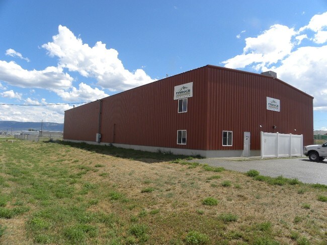
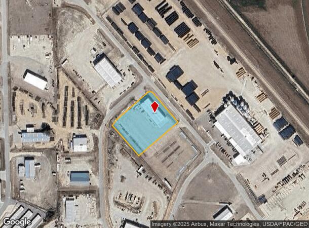
Property Record
2110 Pyrite Rd, Casper, WY 82604

NEARBY LISTINGS FOR SALE OR LEASE
Property Detail
2110 Pyrite Rd
Casper, WY
Air-Rail Ind Pk
34-80-34-1-0-500200
AIR-RAIL IND PK LOT 32 COMMERCIAL
Warehouse
Natrona
X
Wyoming
56025C1670E
32
2024
1.61 AC
2025
I-25 Corridor/Casper
001802
Other Market Areas
9,000 SF
DEMOGRAPHICS near 2110 Pyrite Rd
1 Mile
3 Mile
5 Mile
2024 Total Population
134
4,477
24,962
2029 Population
136
4,523
25,238
Pop Growth 2024-2029
+ 1.49%
+ 1.03%
+ 1.11%
Average Age
46
42
40
2024 Total Households
54
1,845
10,083
HH Growth 2024-2029
0.00%
+ 1.03%
+ 1.10%
Median Household Inc
$101,136
$58,795
$63,477
Avg Household Size
2.30
2.30
2.40
2024 Avg HH Vehicles
3.00
2.00
2.00
Median Home Value
$396,428
$197,856
$208,428
Median Year Built
1977
1978
1977
Nearby Places
Map Layers
Map Styles
 Street
 Aerial
- Restaurants
- Banks
- Shops
- Fitness
- Groceries
PUBLIC TRANSPORTATION
AIRPORT
Casper/Natrona County International
DRIVE
WALK
Distance
Casper/Natrona County International
21 min
9.4 mi
Freight Ports
Tulsa Port Of Catoosa
DRIVE
WALK
Distance
Tulsa Port Of Catoosa
999 min
983.3 mi
SALE & LEASE HISTORY
LISTING DATE
SALE/LEASE

Sep 23, 2016
For Sale
Nearby Properties
Address
Land Use
TOTAL SIZE
Lot Size
Zoning
Address
Land Use
TOTAL SIZE
Lot Size
Zoning
73,903 SF
31.44 AC
Address
Land Use
TOTAL SIZE
Lot Size
Zoning
66,679 SF
5.50 AC
Address
Land Use
TOTAL SIZE
Lot Size
Zoning
25,200 SF
9.68 AC
Address
Land Use
TOTAL SIZE
Lot Size
Zoning
7,500 SF
6.15 AC
Address
Land Use
TOTAL SIZE
Lot Size
Zoning
4,000 SF
12.65 AC
Address
Land Use
TOTAL SIZE
Lot Size
Zoning
59,690 SF
14.68 AC
Address
Land Use
TOTAL SIZE
Lot Size
Zoning
36,000 SF
2.62 AC
Address
Land Use
TOTAL SIZE
Lot Size
Zoning
13,423 SF
28.24 AC
Address
Land Use
TOTAL SIZE
Lot Size
Zoning
800 SF
6.95 AC
Address
Land Use
TOTAL SIZE
Lot Size
Zoning
66,872 SF
9.89 AC
Address
Land Use
TOTAL SIZE
Lot Size
Zoning
28,219 SF
13.96 AC
Address
Land Use
TOTAL SIZE
Lot Size
Zoning
37,635 SF
1.78 AC
Address
Land Use
TOTAL SIZE
Lot Size
Zoning
5,880 SF
25 AC
Address
Land Use
TOTAL SIZE
Lot Size
Zoning
20,600 SF
4.38 AC
Address
Land Use
TOTAL SIZE
Lot Size
Zoning
16,000 SF
1.39 AC
Address
Land Use
TOTAL SIZE
Lot Size
Zoning
54,696 SF
9.50 AC
Address
Land Use
TOTAL SIZE
Lot Size
Zoning
5,028 SF
5.36 AC
Address
Land Use
TOTAL SIZE
Lot Size
Zoning
40,272 SF
10.17 AC
Address
Land Use
TOTAL SIZE
Lot Size
Zoning
14,000 SF
3.21 AC
Address
Land Use
TOTAL SIZE
Lot Size
Zoning
15,090 SF
3.25 AC
Address
Land Use
TOTAL SIZE
Lot Size
Zoning
30,320 SF
3.25 AC
Address
Land Use
TOTAL SIZE
Lot Size
Zoning
24,765 SF
2.76 AC
Address
Land Use
TOTAL SIZE
Lot Size
Zoning
10,680 SF
3.53 AC
Address
Land Use
TOTAL SIZE
Lot Size
Zoning
22,400 SF
4.07 AC
Address
Land Use
TOTAL SIZE
Lot Size
Zoning
13,730 SF
3.32 AC
Address
Land Use
TOTAL SIZE
Lot Size
Zoning
25,498 SF
1.84 AC
Address
Land Use
TOTAL SIZE
Lot Size
Zoning
4,800 SF
14.06 AC
Address
Land Use
TOTAL SIZE
Lot Size
Zoning
13,396 SF
10 AC
Address
Land Use
TOTAL SIZE
Lot Size
Zoning
15,416 SF
2.28 AC
Address
Land Use
TOTAL SIZE
Lot Size
Zoning
9,600 SF
11.19 AC
The World's #1 Commercial Real Estate Marketplace
Connect with us
© 2025 CoStar Group
The information above has been obtained from sources believed reliable. While we do not doubt its accuracy we have not verified it and make no guarantee, warranty or representation about it. It is your responsibility to independently confirm its accuracy and completeness. Any projections, opinions, assumptions, or estimates used are for example only and do not represent the current or future performance of the property. The value of this transaction to you depends on tax and other factors which should be evaluated by your tax, financial, and legal advisors. You and your advisors should conduct a careful, independent investigation of the property to determine to your satisfaction the suitability of the property for your needs.