Property Record
2110 S Sinclair Ave, Stockton, CA 95215

Property Detail
2110 S Sinclair Ave
Stockton-Lodi, CA
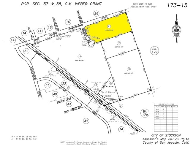
08-FM PT 03/PT TO 12/14/15/RD/04216191/PM 24-146
173-150-13
San Joaquin
Vehiclerentalsvehiclesales
California
C and X Area of minimal flood hazard, usually depicted on FIRMs as above the 500-year flood level.
2
2025
14.76 AC
2025
Stockton
003700
Stockton/Modesto
NEARBY LISTINGS FOR SALE OR LEASE
DEMOGRAPHICS near 2110 S Sinclair Ave
1 mile
3 mile
5 mile
2025 Total Population
6,065
61,108
151,675
2030 Population
6,288
63,590
157,791
Pop Growth 2025-2030
+ 3.68%
+ 4.06%
+ 4.03%
Average Age
35
34
36
2025 Total Households
1,673
16,164
43,450
HH Growth 2025-2030
+ 3.77%
+ 4.16%
+ 4.37%
Median Household Inc
$53,974
$59,740
$61,422
Avg Household Size
3.50
3.60
3.30
2025 Avg HH Vehicles
2.00
2.00
2.00
Median Home Value
$356,997
$347,521
$364,871
Median Year Built
1970
1968
1966
Nearby Places
Map Layers
Map Styles
 Street
 Aerial
Layers
 Traffic
 Biking
Places
Listings with unknown addresses are not visible on the map
- Restaurants
- Banks
- Shops
- Fitness
- Groceries
PUBLIC TRANSPORTATION
COMMUTER RAIL
Stockton- Robert J Cabral Station (ACE Train - Altamont Corridor Express)
Drive
Walk
Distance
Stockton- Robert J Cabral Station (ACE Train - Altamont Corridor Express)
8 min
4.5 mi
Stockton (San Joaquins - Amtrak)
Drive
Walk
Distance
Stockton (San Joaquins - Amtrak)
8 min
5.1 mi
AIRPORT
Stockton Metro
Drive
Walk
Distance
Stockton Metro
12 min
6.9 mi
Freight Ports
Port of Stockton
Drive
Walk
Distance
Port of Stockton
13 min
7.7 mi
Nearby Properties
Address
Land Use
TOTAL SIZE
Lot Size
Zoning
Address
Land Use
TOTAL SIZE
Lot Size
Zoning
57.72 AC
Address
Land Use
TOTAL SIZE
Lot Size
Zoning
1,122,341 SF
61.64 AC
IL
Address
Land Use
TOTAL SIZE
Lot Size
Zoning
67.72 AC
Address
Land Use
TOTAL SIZE
Lot Size
Zoning
615,440 SF
76.23 AC
IG
Address
Land Use
TOTAL SIZE
Lot Size
Zoning
39.06 AC
Address
Land Use
TOTAL SIZE
Lot Size
Zoning
749,983 SF
52.76 AC
Address
Land Use
TOTAL SIZE
Lot Size
Zoning
638,895 SF
76.06 AC
Address
Land Use
TOTAL SIZE
Lot Size
Zoning
35.97 AC
IL
Address
Land Use
TOTAL SIZE
Lot Size
Zoning
780,371 SF
46.04 AC
IG
Address
Land Use
TOTAL SIZE
Lot Size
Zoning
545,832 SF
29.07 AC
Address
Land Use
TOTAL SIZE
Lot Size
Zoning
502,000 SF
19.76 AC
Address
Land Use
TOTAL SIZE
Lot Size
Zoning
574,560 SF
32.34 AC
Address
Land Use
TOTAL SIZE
Lot Size
Zoning
652,548 SF
35.24 AC
IL
Address
Land Use
TOTAL SIZE
Lot Size
Zoning
511,718 SF
21.18 AC
Address
Land Use
TOTAL SIZE
Lot Size
Zoning
285,480 SF
15.70 AC
IL
Address
Land Use
TOTAL SIZE
Lot Size
Zoning
508,800 SF
24 AC
Address
Land Use
TOTAL SIZE
Lot Size
Zoning
735,980 SF
39.42 AC
Address
Land Use
TOTAL SIZE
Lot Size
Zoning
512,000 SF
20.16 AC
Address
Land Use
TOTAL SIZE
Lot Size
Zoning
521,500 SF
12.06 AC
Address
Land Use
TOTAL SIZE
Lot Size
Zoning
513,778 SF
11.88 AC
Address
Land Use
TOTAL SIZE
Lot Size
Zoning
69,954 SF
24.92 AC
Address
Land Use
TOTAL SIZE
Lot Size
Zoning
388,183 SF
18.90 AC
Address
Land Use
TOTAL SIZE
Lot Size
Zoning
586,610 SF
27.36 AC
Address
Land Use
TOTAL SIZE
Lot Size
Zoning
350,892 SF
20.34 AC
Address
Land Use
TOTAL SIZE
Lot Size
Zoning
223,470 SF
21.05 AC
Address
Land Use
TOTAL SIZE
Lot Size
Zoning
265,496 SF
12.37 AC
Address
Land Use
TOTAL SIZE
Lot Size
Zoning
4,110 SF
11.91 AC
IL
Address
Land Use
TOTAL SIZE
Lot Size
Zoning
1,512 SF
77.48 AC
AG40
The World's #1 Commercial Real Estate Marketplace
Connect with us
© 2026 CoStar Group
The information above has been obtained from sources believed reliable. While we do not doubt its accuracy we have not verified it and make no guarantee, warranty or representation about it. It is your responsibility to independently confirm its accuracy and completeness. Any projections, opinions, assumptions, or estimates used are for example only and do not represent the current or future performance of the property. The value of this transaction to you depends on tax and other factors which should be evaluated by your tax, financial, and legal advisors. You and your advisors should conduct a careful, independent investigation of the property to determine to your satisfaction the suitability of the property for your needs.