Property Record
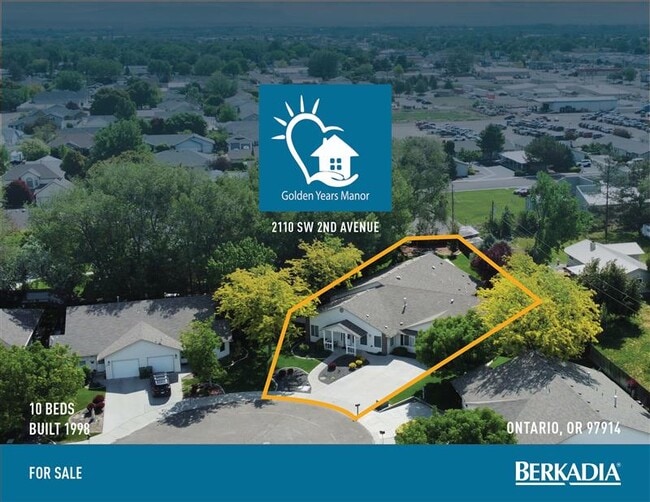
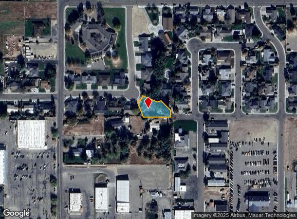
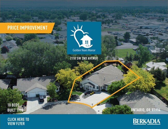
2110 Sw 2Nd Ave, Ontario, OR 97914
NEARBY LISTINGS FOR SALE OR LEASE
Property Detail
2110 Sw 2Nd Ave
Ontario, OR-ID
Well Springs Village Subdivision
18796
Malheur
Multifamilydwelling
Oregon
2025
0.38 AC
2025
Oregon East Area
970200
Other Market Areas
5,050 SF
DEMOGRAPHICS near 2110 Sw 2Nd Ave
1 Mile
3 Mile
5 Mile
2024 Total Population
5,711
14,525
30,811
2029 Population
5,919
15,182
35,053
Pop Growth 2024-2029
+ 3.64%
+ 4.52%
+ 13.77%
Average Age
42
38
39
2024 Total Households
2,226
5,392
11,411
HH Growth 2024-2029
+ 3.91%
+ 4.80%
+ 13.96%
Median Household Inc
$52,213
$46,882
$53,537
Avg Household Size
2.50
2.60
2.60
2024 Avg HH Vehicles
2.00
2.00
2.00
Median Home Value
$215,000
$183,440
$225,019
Median Year Built
1976
1974
1977
Nearby Places
Map Layers
Map Styles
 Street
 Aerial
- Restaurants
- Banks
- Shops
- Fitness
- Groceries
SALE & LEASE HISTORY
LISTING DATE
SALE/LEASE

Oct 21, 2025
For Sale
May 22, 2025
For Sale
Nearby Properties
Address
Land Use
TOTAL SIZE
Lot Size
Zoning
Address
Land Use
TOTAL SIZE
Lot Size
Zoning
50.97 AC
O-I2
Address
Land Use
TOTAL SIZE
Lot Size
Zoning
260,313 SF
5.15 AC
O-C1
Address
Land Use
TOTAL SIZE
Lot Size
Zoning
10 SF
89.11 AC
O-CD
Address
Land Use
TOTAL SIZE
Lot Size
Zoning
10 SF
6.75 AC
O-PF
Address
Land Use
TOTAL SIZE
Lot Size
Zoning
88,574 SF
18.39 AC
O-PF
Address
Land Use
TOTAL SIZE
Lot Size
Zoning
4.74 AC
O-PF
Address
Land Use
TOTAL SIZE
Lot Size
Zoning
50.97 AC
O-I2
Address
Land Use
TOTAL SIZE
Lot Size
Zoning
10 SF
6.57 AC
O-CD
Address
Land Use
TOTAL SIZE
Lot Size
Zoning
36,732 SF
7.14 AC
O-CD
Address
Land Use
TOTAL SIZE
Lot Size
Zoning
1,680 SF
312.83 AC
O-AD
Address
Land Use
TOTAL SIZE
Lot Size
Zoning
4.96 AC
O-C2
Address
Land Use
TOTAL SIZE
Lot Size
Zoning
197,522 SF
19.72 AC
O-C2
Address
Land Use
TOTAL SIZE
Lot Size
Zoning
104,456 SF
8.71 AC
O-C2H
Address
Land Use
TOTAL SIZE
Lot Size
Zoning
141.70 AC
O-I2
Address
Land Use
TOTAL SIZE
Lot Size
Zoning
182.70 AC
O-PF+
Address
Land Use
TOTAL SIZE
Lot Size
Zoning
1 SF
9.63 AC
O-PF
Address
Land Use
TOTAL SIZE
Lot Size
Zoning
37,552 SF
4.15 AC
O-RS
Address
Land Use
TOTAL SIZE
Lot Size
Zoning
62,348 SF
2.24 AC
O-C2
Address
Land Use
TOTAL SIZE
Lot Size
Zoning
47,605 SF
9.07 AC
O-PF
Address
Land Use
TOTAL SIZE
Lot Size
Zoning
11,481.11 AC
C-A2
Address
Land Use
TOTAL SIZE
Lot Size
Zoning
48,892 SF
5.76 AC
O-C2H
Address
Land Use
TOTAL SIZE
Lot Size
Zoning
25,193 SF
4.77 AC
O-RS
Address
Land Use
TOTAL SIZE
Lot Size
Zoning
20,361 SF
2.58 AC
O-RS
Address
Land Use
TOTAL SIZE
Lot Size
Zoning
1.53 AC
O-I2
Address
Land Use
TOTAL SIZE
Lot Size
Zoning
1,560 SF
37.06 AC
O-PF
Address
Land Use
TOTAL SIZE
Lot Size
Zoning
41.81 AC
O-I2+
Address
Land Use
TOTAL SIZE
Lot Size
Zoning
25,355 SF
7.85 AC
O-PF
Address
Land Use
TOTAL SIZE
Lot Size
Zoning
13,110 SF
7.54 AC
O-I1
Address
Land Use
TOTAL SIZE
Lot Size
Zoning
3.94 AC
O-RD+
Address
Land Use
TOTAL SIZE
Lot Size
Zoning
28,660 SF
1.80 AC
O-PF
The World's #1 Commercial Real Estate Marketplace
Connect with us
© 2025 CoStar Group
The information above has been obtained from sources believed reliable. While we do not doubt its accuracy we have not verified it and make no guarantee, warranty or representation about it. It is your responsibility to independently confirm its accuracy and completeness. Any projections, opinions, assumptions, or estimates used are for example only and do not represent the current or future performance of the property. The value of this transaction to you depends on tax and other factors which should be evaluated by your tax, financial, and legal advisors. You and your advisors should conduct a careful, independent investigation of the property to determine to your satisfaction the suitability of the property for your needs.