Property Record
2110 Triglia Way, Davenport, FL 33896
NEARBY LISTINGS FOR SALE OR LEASE
-
-
View all Davenport listings for lease on LoopNet.com
Property Detail
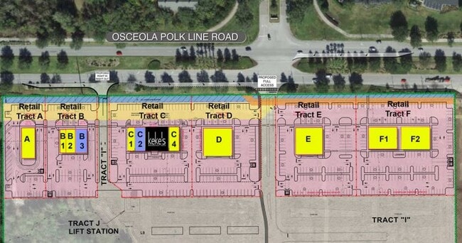
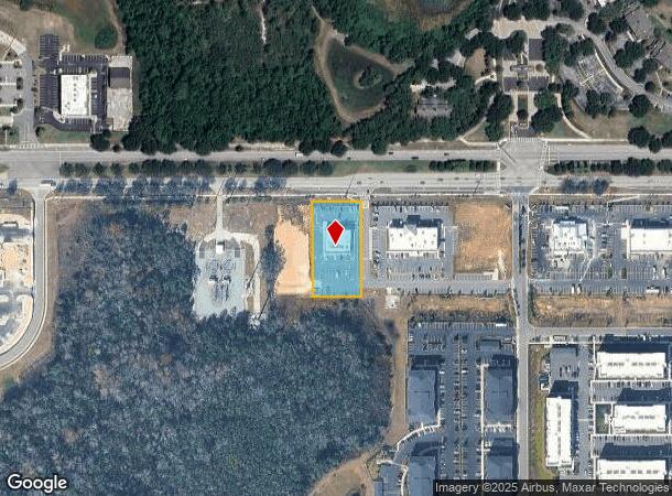
2110 Triglia Way
Lakeland-Winter Haven, FL
Rafina Commercial
27-26-03-701066-000020
RAFINA COMMERCIAL PB 198 PGS 30-32 TRACT B
Storebuilding
Polk
2024
Florida
2025
1.06 AC
012506
Polk County
5,600 SF
Tampa/St Petersburg
DEMOGRAPHICS near 2110 Triglia Way
1 Mile
3 Mile
5 Mile
2024 Total Population
8,721
41,287
98,520
2029 Population
11,031
51,941
123,307
Pop Growth 2024-2029
+ 26.49%
+ 25.80%
+ 25.16%
Average Age
37
38
39
2024 Total Households
3,297
15,252
36,090
HH Growth 2024-2029
+ 26.36%
+ 25.73%
+ 25.16%
Median Household Inc
$55,388
$65,878
$69,486
Avg Household Size
2.50
2.70
2.70
2024 Avg HH Vehicles
2.00
2.00
2.00
Median Home Value
$279,674
$278,079
$279,499
Median Year Built
2007
2007
2007
Nearby Places
Map Layers
Map Styles
 Street
 Aerial
- Restaurants
- Banks
- Shops
- Fitness
- Groceries
PUBLIC TRANSPORTATION
COMMUTER RAIL
Poinciana (SunRail - Florida Department of Transportation)
DRIVE
WALK
Distance
Poinciana (SunRail - Florida Department of Transportation)
11 min
7.4 mi
AIRPORT
Orlando International
DRIVE
WALK
Distance
Orlando International
36 min
27.0 mi
Freight Ports
Port of Tampa Bay
DRIVE
WALK
Distance
Port of Tampa Bay
72 min
60.8 mi
SALE & LEASE HISTORY
LISTING DATE
SALE/LEASE

Jan 24, 2022
For Lease
Nearby Properties
Address
Land Use
TOTAL SIZE
Lot Size
Zoning
Address
Land Use
TOTAL SIZE
Lot Size
Zoning
736,399 SF
23.59 AC
OPD
Address
Land Use
TOTAL SIZE
Lot Size
Zoning
417,544 SF
62.60 AC
Address
Land Use
TOTAL SIZE
Lot Size
Zoning
434,491 SF
27.48 AC
Address
Land Use
TOTAL SIZE
Lot Size
Zoning
295,034 SF
14.25 AC
Address
Land Use
TOTAL SIZE
Lot Size
Zoning
597,078 SF
51.33 AC
Address
Land Use
TOTAL SIZE
Lot Size
Zoning
422,457 SF
17.46 AC
Address
Land Use
TOTAL SIZE
Lot Size
Zoning
425,752 SF
19.52 AC
Address
Land Use
TOTAL SIZE
Lot Size
Zoning
436,302 SF
27.87 AC
Address
Land Use
TOTAL SIZE
Lot Size
Zoning
480,104 SF
12.37 AC
Address
Land Use
TOTAL SIZE
Lot Size
Zoning
358,576 SF
27.34 AC
OPD
Address
Land Use
TOTAL SIZE
Lot Size
Zoning
302,226 SF
135.83 AC
Address
Land Use
TOTAL SIZE
Lot Size
Zoning
412,886 SF
10.72 AC
Address
Land Use
TOTAL SIZE
Lot Size
Zoning
335,536 SF
11.97 AC
Address
Land Use
TOTAL SIZE
Lot Size
Zoning
333,554 SF
19.22 AC
Address
Land Use
TOTAL SIZE
Lot Size
Zoning
329,700 SF
12.09 AC
Address
Land Use
TOTAL SIZE
Lot Size
Zoning
307,953 SF
16.20 AC
Address
Land Use
TOTAL SIZE
Lot Size
Zoning
360,801 SF
8.24 AC
Address
Land Use
TOTAL SIZE
Lot Size
Zoning
352,892 SF
19.23 AC
Address
Land Use
TOTAL SIZE
Lot Size
Zoning
336,042 SF
20.77 AC
Address
Land Use
TOTAL SIZE
Lot Size
Zoning
256,589 SF
15.37 AC
OPD
Address
Land Use
TOTAL SIZE
Lot Size
Zoning
216,296 SF
16.37 AC
Address
Land Use
TOTAL SIZE
Lot Size
Zoning
338,315 SF
59.58 AC
Address
Land Use
TOTAL SIZE
Lot Size
Zoning
236,745 SF
26.56 AC
Address
Land Use
TOTAL SIZE
Lot Size
Zoning
164,106 SF
7.13 AC
Address
Land Use
TOTAL SIZE
Lot Size
Zoning
228,683 SF
13.54 AC
RC
Address
Land Use
TOTAL SIZE
Lot Size
Zoning
108,948 SF
10.62 AC
OPD
Address
Land Use
TOTAL SIZE
Lot Size
Zoning
88,884 SF
3.34 AC
Address
Land Use
TOTAL SIZE
Lot Size
Zoning
62,808 SF
7.09 AC
OPD
Address
Land Use
TOTAL SIZE
Lot Size
Zoning
87,848 SF
14.44 AC
OAC
Address
Land Use
TOTAL SIZE
Lot Size
Zoning
99,639 SF
11 AC
The World's #1 Commercial Real Estate Marketplace
Connect with us
© 2025 CoStar Group
The information above has been obtained from sources believed reliable. While we do not doubt its accuracy we have not verified it and make no guarantee, warranty or representation about it. It is your responsibility to independently confirm its accuracy and completeness. Any projections, opinions, assumptions, or estimates used are for example only and do not represent the current or future performance of the property. The value of this transaction to you depends on tax and other factors which should be evaluated by your tax, financial, and legal advisors. You and your advisors should conduct a careful, independent investigation of the property to determine to your satisfaction the suitability of the property for your needs.