Property Record
21101 E State Route 78 Hwy, Independence, MO 64057

Current Lease Availabilities
Property Detail
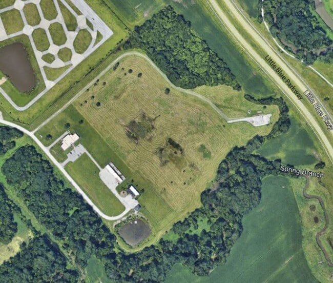
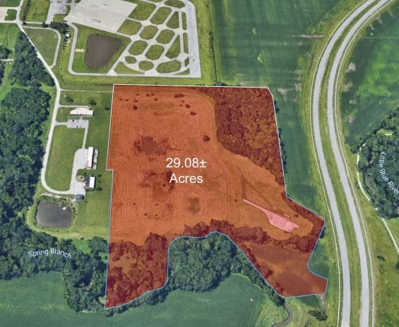
21101 E State Route 78 Hwy
24-400-02-10-00-0-00-000
RNG-31 TWP-49 SEC- BEG 620 S NE COR NW 1/4 NW 1/4 TH E 300 TH S 898 TH TH S 58 DEG E 150 TH S 32 DEG W 200 TH WLY F OL BRANCH TO A PT 210 E & 150 S NW COR SW 1 /4 NW 1/4 TH N
Utilities
Jackson
AH Areas with a 1% annual chance of shallow flooding, usually in the form of a pond, withan average depth ranging from 1 to 3 feet. These areas have a 26% chance of flooding over the life of a 30-year mortgage.
Missouri
2024
37 AC
2025
East Jackson County
014702
Kansas City
26,982 SF
Kansas City, MO-KS
NEARBY LISTINGS FOR SALE OR LEASE
DEMOGRAPHICS near 21101 E State Route 78 Hwy
1 mile
3 mile
5 mile
2025 Total Population
1,022
22,883
103,373
2030 Population
1,028
23,011
103,428
Pop Growth 2025-2030
+ 0.59%
+ 0.56%
+ 0.05%
Average Age
42
42
41
2025 Total Households
393
9,192
41,312
HH Growth 2025-2030
+ 0.51%
+ 0.59%
+ 0.05%
Median Household Inc
$73,949
$76,762
$72,227
Avg Household Size
2.50
2.40
2.40
2025 Avg HH Vehicles
2.00
2.00
2.00
Median Home Value
$254,950
$248,588
$224,659
Median Year Built
1996
1986
1977
Nearby Places
Map Layers
Map Styles
 Street
 Aerial
Transit
 Traffic
 Biking
Places
Listings with unknown addresses are not visible on the map
- Restaurants
- Banks
- Shops
- Fitness
- Groceries
PUBLIC TRANSPORTATION
COMMUTER RAIL
Independence Amtrak Station (Lincoln Service Missouri River Runner - Amtrak, Missouri River Runner - Amtrak)
Drive
Walk
Distance
Independence Amtrak Station (Lincoln Service Missouri River Runner - Amtrak, Missouri River Runner - Amtrak)
12 min
6.3 mi
AIRPORT
Kansas City International
Drive
Walk
Distance
Kansas City International
49 min
34.0 mi
Freight Ports
Tulsa Port Of Catoosa
Drive
Walk
Distance
Tulsa Port Of Catoosa
282 min
251.7 mi
Nearby Properties
Address
Land Use
TOTAL SIZE
Lot Size
Zoning
Address
Land Use
TOTAL SIZE
Lot Size
Zoning
398,212 SF
73.80 AC
Address
Land Use
TOTAL SIZE
Lot Size
Zoning
100,724 SF
1.65 AC
Address
Land Use
TOTAL SIZE
Lot Size
Zoning
250,196 SF
39.50 AC
Address
Land Use
TOTAL SIZE
Lot Size
Zoning
385,487 SF
5.61 AC
Address
Land Use
TOTAL SIZE
Lot Size
Zoning
Address
Land Use
TOTAL SIZE
Lot Size
Zoning
179,962 SF
16.02 AC
Address
Land Use
TOTAL SIZE
Lot Size
Zoning
31,674 SF
11.45 AC
Address
Land Use
TOTAL SIZE
Lot Size
Zoning
287,132 SF
Address
Land Use
TOTAL SIZE
Lot Size
Zoning
193,191 SF
4.14 AC
Address
Land Use
TOTAL SIZE
Lot Size
Zoning
286,547 SF
Address
Land Use
TOTAL SIZE
Lot Size
Zoning
68,921 SF
18.04 AC
Address
Land Use
TOTAL SIZE
Lot Size
Zoning
157,429 SF
36.60 AC
Address
Land Use
TOTAL SIZE
Lot Size
Zoning
56,664 SF
Address
Land Use
TOTAL SIZE
Lot Size
Zoning
24,225 SF
Address
Land Use
TOTAL SIZE
Lot Size
Zoning
45,870 SF
2.01 AC
Address
Land Use
TOTAL SIZE
Lot Size
Zoning
64,887 SF
17.50 AC
Address
Land Use
TOTAL SIZE
Lot Size
Zoning
42,688 SF
2.90 AC
Address
Land Use
TOTAL SIZE
Lot Size
Zoning
153,774 SF
Address
Land Use
TOTAL SIZE
Lot Size
Zoning
101,268 SF
13.09 AC
Address
Land Use
TOTAL SIZE
Lot Size
Zoning
48,330 SF
12.31 AC
Address
Land Use
TOTAL SIZE
Lot Size
Zoning
246,652 SF
5.07 AC
Address
Land Use
TOTAL SIZE
Lot Size
Zoning
46,489 SF
2.07 AC
Address
Land Use
TOTAL SIZE
Lot Size
Zoning
152,806 SF
94.25 AC
Address
Land Use
TOTAL SIZE
Lot Size
Zoning
10,420 SF
2.74 AC
Address
Land Use
TOTAL SIZE
Lot Size
Zoning
34,592 SF
1.74 AC
Address
Land Use
TOTAL SIZE
Lot Size
Zoning
47,978 SF
10.20 AC
Address
Land Use
TOTAL SIZE
Lot Size
Zoning
62,070 SF
5.35 AC
Address
Land Use
TOTAL SIZE
Lot Size
Zoning
65,349 SF
15.77 AC
Address
Land Use
TOTAL SIZE
Lot Size
Zoning
23,590 SF
2.30 AC
Address
Land Use
TOTAL SIZE
Lot Size
Zoning
33,360 SF
3.50 AC
The World's #1 Commercial Real Estate Marketplace
Connect with us
© 2026 CoStar Group
The information above has been obtained from sources believed reliable. While we do not doubt its accuracy we have not verified it and make no guarantee, warranty or representation about it. It is your responsibility to independently confirm its accuracy and completeness. Any projections, opinions, assumptions, or estimates used are for example only and do not represent the current or future performance of the property. The value of this transaction to you depends on tax and other factors which should be evaluated by your tax, financial, and legal advisors. You and your advisors should conduct a careful, independent investigation of the property to determine to your satisfaction the suitability of the property for your needs.