Property Record
21101 E State Route 78 Hwy, Independence, MO 64057
Current Lease Availabilities
NEARBY LISTINGS FOR SALE OR LEASE
Property Detail
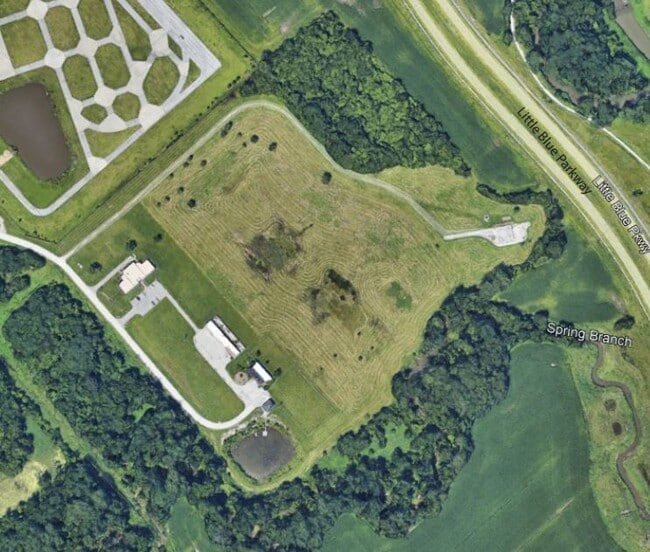
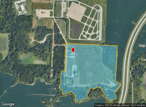
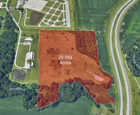
21101 E State Route 78 Hwy
24-400-02-10-00-0-00-000
RNG-31 TWP-49 SEC- BEG 620 S NE COR NW 1/4 NW 1/4 TH E 300 TH S 898 TH TH S 58 DEG E 150 TH S 32 DEG W 200 TH WLY F OL BRANCH TO A PT 210 E & 150 S NW COR SW 1 /4 NW 1/4 TH N
Utilities
Jackson
AH
Missouri
29095C0304G
37 AC
2024
East Jackson County
2025
Kansas City
014702
Kansas City, MO-KS
26,982 SF
DEMOGRAPHICS near 21101 E State Route 78 Hwy
1 Mile
3 Mile
5 Mile
2024 Total Population
992
22,224
101,136
2029 Population
981
21,982
99,848
Pop Growth 2024-2029
(1.11%)
(1.09%)
(1.27%)
Average Age
42
42
41
2024 Total Households
381
8,951
40,343
HH Growth 2024-2029
(1.31%)
(1.15%)
(1.38%)
Median Household Inc
$67,500
$71,528
$69,008
Avg Household Size
2.50
2.40
2.40
2024 Avg HH Vehicles
2.00
2.00
2.00
Median Home Value
$247,426
$218,785
$192,875
Median Year Built
1994
1985
1977
Nearby Places
Map Layers
Map Styles
 Street
 Aerial
- Restaurants
- Banks
- Shops
- Fitness
- Groceries
PUBLIC TRANSPORTATION
COMMUTER RAIL
DRIVE
WALK
Distance
14 min
6.8 mi
AIRPORT
Kansas City International
DRIVE
WALK
Distance
Kansas City International
51 min
34.5 mi
Nearby Properties
Address
Land Use
TOTAL SIZE
Lot Size
Zoning
Address
Land Use
TOTAL SIZE
Lot Size
Zoning
398,212 SF
73.80 AC
Address
Land Use
TOTAL SIZE
Lot Size
Zoning
100,724 SF
1.65 AC
Address
Land Use
TOTAL SIZE
Lot Size
Zoning
250,196 SF
39.50 AC
Address
Land Use
TOTAL SIZE
Lot Size
Zoning
385,487 SF
5.61 AC
Address
Land Use
TOTAL SIZE
Lot Size
Zoning
338,731 SF
29.59 AC
Address
Land Use
TOTAL SIZE
Lot Size
Zoning
120,053 SF
13.53 AC
Address
Land Use
TOTAL SIZE
Lot Size
Zoning
179,962 SF
16.02 AC
Address
Land Use
TOTAL SIZE
Lot Size
Zoning
31,674 SF
11.45 AC
Address
Land Use
TOTAL SIZE
Lot Size
Zoning
287,132 SF
Address
Land Use
TOTAL SIZE
Lot Size
Zoning
193,191 SF
4.14 AC
Address
Land Use
TOTAL SIZE
Lot Size
Zoning
286,547 SF
Address
Land Use
TOTAL SIZE
Lot Size
Zoning
68,921 SF
18.04 AC
Address
Land Use
TOTAL SIZE
Lot Size
Zoning
157,429 SF
36.60 AC
Address
Land Use
TOTAL SIZE
Lot Size
Zoning
56,664 SF
Address
Land Use
TOTAL SIZE
Lot Size
Zoning
48,464 SF
6.43 AC
Address
Land Use
TOTAL SIZE
Lot Size
Zoning
24,225 SF
Address
Land Use
TOTAL SIZE
Lot Size
Zoning
45,870 SF
2.01 AC
Address
Land Use
TOTAL SIZE
Lot Size
Zoning
30,630 SF
14.08 AC
Address
Land Use
TOTAL SIZE
Lot Size
Zoning
54,550 SF
5.87 AC
Address
Land Use
TOTAL SIZE
Lot Size
Zoning
64,887 SF
17.50 AC
Address
Land Use
TOTAL SIZE
Lot Size
Zoning
97,497 SF
7.05 AC
Address
Land Use
TOTAL SIZE
Lot Size
Zoning
42,688 SF
2.90 AC
Address
Land Use
TOTAL SIZE
Lot Size
Zoning
62,332 SF
4.37 AC
Address
Land Use
TOTAL SIZE
Lot Size
Zoning
208,598 SF
3.88 AC
Address
Land Use
TOTAL SIZE
Lot Size
Zoning
153,774 SF
Address
Land Use
TOTAL SIZE
Lot Size
Zoning
101,268 SF
13.09 AC
Address
Land Use
TOTAL SIZE
Lot Size
Zoning
48,330 SF
12.31 AC
Address
Land Use
TOTAL SIZE
Lot Size
Zoning
246,652 SF
5.07 AC
Address
Land Use
TOTAL SIZE
Lot Size
Zoning
46,489 SF
2.07 AC
Address
Land Use
TOTAL SIZE
Lot Size
Zoning
152,806 SF
94.25 AC
The World's #1 Commercial Real Estate Marketplace
Connect with us
© 2025 CoStar Group
The information above has been obtained from sources believed reliable. While we do not doubt its accuracy we have not verified it and make no guarantee, warranty or representation about it. It is your responsibility to independently confirm its accuracy and completeness. Any projections, opinions, assumptions, or estimates used are for example only and do not represent the current or future performance of the property. The value of this transaction to you depends on tax and other factors which should be evaluated by your tax, financial, and legal advisors. You and your advisors should conduct a careful, independent investigation of the property to determine to your satisfaction the suitability of the property for your needs.