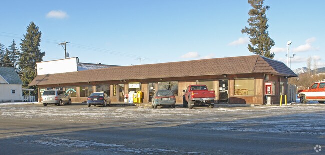
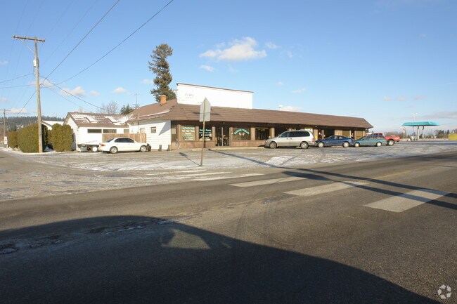
Property Record
21101 E Wellesley Ave, Otis Orchards, WA 99027

NEARBY LISTINGS FOR SALE OR LEASE
Property Detail
21101 E Wellesley Ave
56334.0401
BSP 2005-100 PARCEL A (AFN# 5399283); TOG W E 5 FT VAC KENNEY RD W OF AND ADJ; AND TOGETHER WITH THAT PORTION THEREOF LYING NORTHEASTERLY OF AN ARC HAVING A 20 FOOT RADIUS CONCAVE NORTHEASTERLY, THE ENDS OF SAID ARC BEING TANGENT WITH A LINE PARALLEL
Storebuilding
Spokane
X
Washington
53063C0605D
0.95 AC
2025
Valley
2025
Spokane
013201
Spokane-Spokane Valley, WA
2,340 SF
DEMOGRAPHICS near 21101 E Wellesley Ave
1 Mile
3 Mile
5 Mile
2024 Total Population
2,211
23,793
61,964
2029 Population
2,327
25,429
66,735
Pop Growth 2024-2029
+ 5.25%
+ 6.88%
+ 7.70%
Average Age
44
42
40
2024 Total Households
867
9,443
24,214
HH Growth 2024-2029
+ 5.42%
+ 7.11%
+ 7.87%
Median Household Inc
$78,203
$79,241
$76,275
Avg Household Size
2.50
2.50
2.50
2024 Avg HH Vehicles
3.00
2.00
2.00
Median Home Value
$377,468
$410,031
$410,497
Median Year Built
1979
1995
1996
Nearby Places
Map Layers
Map Styles
 Street
 Aerial
- Restaurants
- Banks
- Shops
- Fitness
- Groceries
PUBLIC TRANSPORTATION
AIRPORT
Spokane International
DRIVE
WALK
Distance
Spokane International
32 min
21.1 mi
Freight Ports
Port of Everett
DRIVE
WALK
Distance
Port of Everett
360 min
316.7 mi
Nearby Properties
Address
Land Use
TOTAL SIZE
Lot Size
Zoning
Address
Land Use
TOTAL SIZE
Lot Size
Zoning
1,326,772 SF
85.91 AC
I-2
Address
Land Use
TOTAL SIZE
Lot Size
Zoning
275,534 SF
67.98 AC
P
Address
Land Use
TOTAL SIZE
Lot Size
Zoning
296,760 SF
37.61 AC
I-1
Address
Land Use
TOTAL SIZE
Lot Size
Zoning
602,024 SF
44.20 AC
I
Address
Land Use
TOTAL SIZE
Lot Size
Zoning
358,700 SF
16.41 AC
R3
Address
Land Use
TOTAL SIZE
Lot Size
Zoning
98,088 SF
13.94 AC
SAP
Address
Land Use
TOTAL SIZE
Lot Size
Zoning
153,691 SF
24.92 AC
P
Address
Land Use
TOTAL SIZE
Lot Size
Zoning
133,310 SF
10.93 AC
M2
Address
Land Use
TOTAL SIZE
Lot Size
Zoning
150,936 SF
9.30 AC
M2
Address
Land Use
TOTAL SIZE
Lot Size
Zoning
68,928 SF
10.96 AC
R-3
Address
Land Use
TOTAL SIZE
Lot Size
Zoning
145,884 SF
6.87 AC
M2
Address
Land Use
TOTAL SIZE
Lot Size
Zoning
144,544 SF
9.65 AC
I-1
Address
Land Use
TOTAL SIZE
Lot Size
Zoning
144,349 SF
8.06 AC
I-2
Address
Land Use
TOTAL SIZE
Lot Size
Zoning
105,457 SF
9.69 AC
SAP
Address
Land Use
TOTAL SIZE
Lot Size
Zoning
192,384 SF
9.63 AC
I-2
Address
Land Use
TOTAL SIZE
Lot Size
Zoning
78,795 SF
39.53 AC
C2
Address
Land Use
TOTAL SIZE
Lot Size
Zoning
120,798 SF
8.66 AC
I-2
Address
Land Use
TOTAL SIZE
Lot Size
Zoning
120,798 SF
8.03 AC
I-2
Address
Land Use
TOTAL SIZE
Lot Size
Zoning
82,600 SF
9.27 AC
I
Address
Land Use
TOTAL SIZE
Lot Size
Zoning
104,962 SF
4.86 AC
Address
Land Use
TOTAL SIZE
Lot Size
Zoning
64,280 SF
5.80 AC
I
Address
Land Use
TOTAL SIZE
Lot Size
Zoning
154,265 SF
13.38 AC
I
Address
Land Use
TOTAL SIZE
Lot Size
Zoning
136,894 SF
8.20 AC
I-2
Address
Land Use
TOTAL SIZE
Lot Size
Zoning
184,710 SF
13.12 AC
I
Address
Land Use
TOTAL SIZE
Lot Size
Zoning
202,570 SF
21.72 AC
I
Address
Land Use
TOTAL SIZE
Lot Size
Zoning
296,341 SF
23.08 AC
I
Address
Land Use
TOTAL SIZE
Lot Size
Zoning
105,600 SF
7.50 AC
I-2
Address
Land Use
TOTAL SIZE
Lot Size
Zoning
140,395 SF
10.44 AC
I
Address
Land Use
TOTAL SIZE
Lot Size
Zoning
102,529 SF
13.98 AC
M2
Address
Land Use
TOTAL SIZE
Lot Size
Zoning
64,280 SF
7.98 AC
I
The World's #1 Commercial Real Estate Marketplace
Connect with us
© 2025 CoStar Group
The information above has been obtained from sources believed reliable. While we do not doubt its accuracy we have not verified it and make no guarantee, warranty or representation about it. It is your responsibility to independently confirm its accuracy and completeness. Any projections, opinions, assumptions, or estimates used are for example only and do not represent the current or future performance of the property. The value of this transaction to you depends on tax and other factors which should be evaluated by your tax, financial, and legal advisors. You and your advisors should conduct a careful, independent investigation of the property to determine to your satisfaction the suitability of the property for your needs.