Property Record
2111 E Pembroke Ave, Hampton, VA 23664
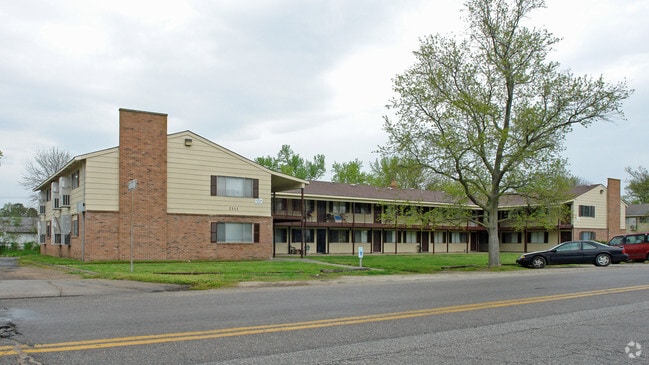

Property Detail
2111 E Pembroke Ave
12006190
BUCKROE HEIGHTS ADD L20-29. BA
Highriseapartments
Hampton City
9 R-M MULT
Virginia
C and X Area of minimal flood hazard, usually depicted on FIRMs as above the 500-year flood level.
20-29
2025
1.72 AC
2025
Buckroe Beach
011001
Hampton Roads
15,912 SF
Virginia Beach-Chesapeake-Norfolk, VA-NC
NEARBY LISTINGS FOR SALE OR LEASE
-
-
View all Hampton listings for sale on LoopNet.com
DEMOGRAPHICS near 2111 E Pembroke Ave
1 mile
3 mile
5 mile
2025 Total Population
11,477
52,172
84,310
2030 Population
11,454
51,966
84,543
Pop Growth 2025-2030
(0.20%)
(0.39%)
+ 0.28%
Average Age
40
40
39
2025 Total Households
4,792
21,192
34,734
HH Growth 2025-2030
(0.17%)
(0.10%)
+ 0.37%
Median Household Inc
$62,393
$75,297
$72,291
Avg Household Size
2.30
2.30
2.30
2025 Avg HH Vehicles
2.00
2.00
2.00
Median Home Value
$241,439
$252,379
$250,124
Median Year Built
1969
1971
1971
Nearby Places
Map Layers
Map Styles
 Street
 Aerial
Layers
 Traffic
 Biking
Places
Listings with unknown addresses are not visible on the map
- Restaurants
- Banks
- Shops
- Fitness
- Groceries
PUBLIC TRANSPORTATION
AIRPORT
Newport News/Williamsburg International
Drive
Walk
Distance
Newport News/Williamsburg International
26 min
16.4 mi
Norfolk International
Drive
Walk
Distance
Norfolk International
27 min
16.5 mi
Freight Ports
Virginia Port Authority - Newport News
Drive
Walk
Distance
Virginia Port Authority - Newport News
17 min
10.4 mi
Nearby Properties
Address
Land Use
TOTAL SIZE
Lot Size
Zoning
Address
Land Use
TOTAL SIZE
Lot Size
Zoning
1 SF
92.67 AC
5 R-13 ONE
Address
Land Use
TOTAL SIZE
Lot Size
Zoning
83.50 AC
5 R-13 ONE
Address
Land Use
TOTAL SIZE
Lot Size
Zoning
7,644 SF
322.21 AC
19 PO-1 GE
Address
Land Use
TOTAL SIZE
Lot Size
Zoning
112,089 SF
11.95 AC
30 DT-3 DO
Address
Land Use
TOTAL SIZE
Lot Size
Zoning
204,584 SF
34.79 AC
6 R-11 ONE
Address
Land Use
TOTAL SIZE
Lot Size
Zoning
240,000 SF
30.38 AC
7 R-9 ONE
Address
Land Use
TOTAL SIZE
Lot Size
Zoning
73,668 SF
3.24 AC
30 DT-3 DO
Address
Land Use
TOTAL SIZE
Lot Size
Zoning
110,080 SF
2.21 AC
29 DT-2 DO
Address
Land Use
TOTAL SIZE
Lot Size
Zoning
4.99 AC
47 PH-2 PH
Address
Land Use
TOTAL SIZE
Lot Size
Zoning
114,040 SF
1.46 AC
28 DT-1 DO
Address
Land Use
TOTAL SIZE
Lot Size
Zoning
140,649 SF
25.29 AC
7 R-9 ONE
Address
Land Use
TOTAL SIZE
Lot Size
Zoning
253,896 SF
13.32 AC
9 R-M MULT
Address
Land Use
TOTAL SIZE
Lot Size
Zoning
2,106 SF
191.59 AC
42 FM-1 FO
Address
Land Use
TOTAL SIZE
Lot Size
Zoning
123,151 SF
21.81 AC
5 R-13 ONE
Address
Land Use
TOTAL SIZE
Lot Size
Zoning
127,600 SF
27.95 AC
5 R-13 ONE
Address
Land Use
TOTAL SIZE
Lot Size
Zoning
204,803 SF
4.97 AC
43 FM-2 FO
Address
Land Use
TOTAL SIZE
Lot Size
Zoning
27,710 SF
14.38 AC
0 MD-2 MUL
Address
Land Use
TOTAL SIZE
Lot Size
Zoning
31,748 SF
5.30 AC
5 R-13 ONE
Address
Land Use
TOTAL SIZE
Lot Size
Zoning
11,772 SF
10.86 AC
0 MD-2 MUL
Address
Land Use
TOTAL SIZE
Lot Size
Zoning
122,256 SF
4.80 AC
11 MD-4 MU
Address
Land Use
TOTAL SIZE
Lot Size
Zoning
808 SF
112.03 AC
19 PO-1 GE
Address
Land Use
TOTAL SIZE
Lot Size
Zoning
2,204 SF
90.11 AC
19 PO-1 GE
Address
Land Use
TOTAL SIZE
Lot Size
Zoning
149,244 SF
5.47 AC
11 MD-4 MU
Address
Land Use
TOTAL SIZE
Lot Size
Zoning
115,889 SF
0.92 AC
28 DT-1 DO
Address
Land Use
TOTAL SIZE
Lot Size
Zoning
6,150 SF
9.71 AC
7 R-9 ONE
Address
Land Use
TOTAL SIZE
Lot Size
Zoning
77,023 SF
1.13 AC
28 DT-1 DO
Address
Land Use
TOTAL SIZE
Lot Size
Zoning
143,999 SF
13.64 AC
13 C-1 NEI
Address
Land Use
TOTAL SIZE
Lot Size
Zoning
148,176 SF
10.20 AC
18 MD-1 TO
Address
Land Use
TOTAL SIZE
Lot Size
Zoning
203,695 SF
0.51 AC
29 DT-2 DO
Address
Land Use
TOTAL SIZE
Lot Size
Zoning
139,032 SF
7.70 AC
6 R-11 ONE
The World's #1 Commercial Real Estate Marketplace
Connect with us
© 2026 CoStar Group
The information above has been obtained from sources believed reliable. While we do not doubt its accuracy we have not verified it and make no guarantee, warranty or representation about it. It is your responsibility to independently confirm its accuracy and completeness. Any projections, opinions, assumptions, or estimates used are for example only and do not represent the current or future performance of the property. The value of this transaction to you depends on tax and other factors which should be evaluated by your tax, financial, and legal advisors. You and your advisors should conduct a careful, independent investigation of the property to determine to your satisfaction the suitability of the property for your needs.