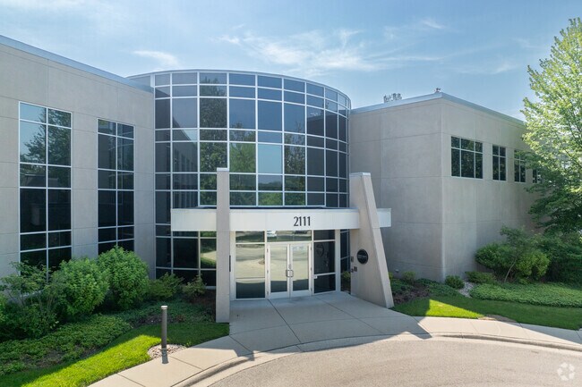
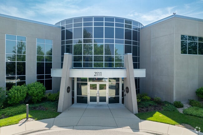
Property Record
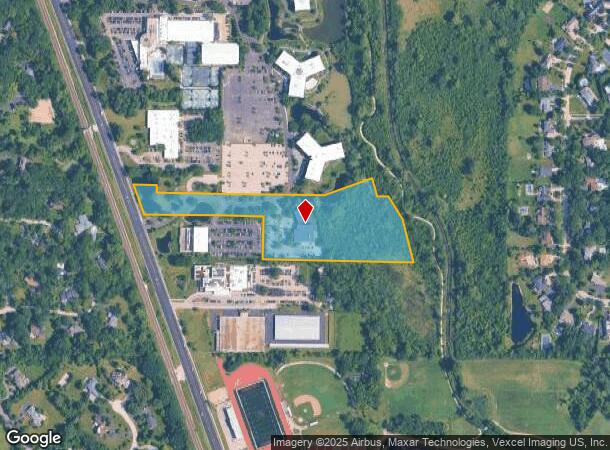
2111 Waukegan Rd, Bannockburn, IL 60015
NEARBY LISTINGS FOR SALE OR LEASE
Property Detail
2111 Waukegan Rd
16-20-200-047
PT N 1/2; BEG AT INTERSECTION ELY LN WAUKEGAN RD WI N LN S 7 91 N1/2 SEC 20, N20D0730W ALG ELY LN SD RD 185.37, S89D5 242E 160.72, S00D1042W 46.67, S89D5242E 975.82, N69
Commercialbuilding
Lake
AE
Illinois
17097C0278K
9.70 AC
2023
Central North
2024
Chicago
864801
Chicago-Naperville-Elgin, IL-IN-WI
38,124 SF
DEMOGRAPHICS near 2111 Waukegan Rd
1 Mile
3 Mile
5 Mile
2024 Total Population
4,297
58,377
131,093
2029 Population
4,218
57,651
129,327
Pop Growth 2024-2029
(1.84%)
(1.24%)
(1.35%)
Average Age
40
43
43
2024 Total Households
1,309
21,265
49,037
HH Growth 2024-2029
(2.14%)
(1.28%)
(1.44%)
Median Household Inc
$184,728
$153,709
$139,613
Avg Household Size
2.90
2.70
2.60
2024 Avg HH Vehicles
2.00
2.00
2.00
Median Home Value
$765,802
$632,503
$600,337
Median Year Built
1973
1971
1975
Nearby Places
Map Layers
Map Styles
 Street
 Aerial
- Restaurants
- Banks
- Shops
- Fitness
- Groceries
PUBLIC TRANSPORTATION
COMMUTER RAIL
Deerfield Station (Milwaukee District North Line - Northeast Illinois Regional Commuter Railroad (Metra))
DRIVE
WALK
Distance
Deerfield Station (Milwaukee District North Line - Northeast Illinois Regional Commuter Railroad (Metra))
5 min
2.3 mi
Highwood Station (Union Pacific North Line - Northeast Illinois Regional Commuter Railroad (Metra))
DRIVE
WALK
Distance
Highwood Station (Union Pacific North Line - Northeast Illinois Regional Commuter Railroad (Metra))
8 min
3.9 mi
AIRPORT
Chicago O'Hare International
DRIVE
WALK
Distance
Chicago O'Hare International
29 min
19.3 mi
Chicago Midway International
DRIVE
WALK
Distance
Chicago Midway International
52 min
34.3 mi
Freight Ports
Port Milwaukee
DRIVE
WALK
Distance
Port Milwaukee
73 min
61.0 mi
Nearby Properties
Address
Land Use
TOTAL SIZE
Lot Size
Zoning
Address
Land Use
TOTAL SIZE
Lot Size
Zoning
6,783,684 SF
69.84 AC
Address
Land Use
TOTAL SIZE
Lot Size
Zoning
815,308 SF
12.95 AC
Address
Land Use
TOTAL SIZE
Lot Size
Zoning
708,522 SF
17.11 AC
Address
Land Use
TOTAL SIZE
Lot Size
Zoning
244,300 SF
2.46 AC
Address
Land Use
TOTAL SIZE
Lot Size
Zoning
301,050 SF
11.22 AC
Address
Land Use
TOTAL SIZE
Lot Size
Zoning
864,590 SF
2.64 AC
Address
Land Use
TOTAL SIZE
Lot Size
Zoning
21.58 AC
Address
Land Use
TOTAL SIZE
Lot Size
Zoning
806,580 SF
7.64 AC
Address
Land Use
TOTAL SIZE
Lot Size
Zoning
315,160 SF
15.50 AC
Address
Land Use
TOTAL SIZE
Lot Size
Zoning
1,049,337 SF
24.57 AC
Address
Land Use
TOTAL SIZE
Lot Size
Zoning
653,040 SF
7.96 AC
Address
Land Use
TOTAL SIZE
Lot Size
Zoning
0.57 AC
Address
Land Use
TOTAL SIZE
Lot Size
Zoning
8,586,994 SF
10.41 AC
Address
Land Use
TOTAL SIZE
Lot Size
Zoning
188,987 SF
6.65 AC
Address
Land Use
TOTAL SIZE
Lot Size
Zoning
78.54 AC
Address
Land Use
TOTAL SIZE
Lot Size
Zoning
129,900 SF
0.76 AC
Address
Land Use
TOTAL SIZE
Lot Size
Zoning
698,127 SF
7.94 AC
Address
Land Use
TOTAL SIZE
Lot Size
Zoning
191,025 SF
15.66 AC
Address
Land Use
TOTAL SIZE
Lot Size
Zoning
510,213 SF
1.27 AC
Address
Land Use
TOTAL SIZE
Lot Size
Zoning
349,846 SF
5.11 AC
Address
Land Use
TOTAL SIZE
Lot Size
Zoning
13.88 AC
Address
Land Use
TOTAL SIZE
Lot Size
Zoning
221,786 SF
6.33 AC
Address
Land Use
TOTAL SIZE
Lot Size
Zoning
74,599 SF
9.16 AC
Address
Land Use
TOTAL SIZE
Lot Size
Zoning
79,073 SF
8.70 AC
Address
Land Use
TOTAL SIZE
Lot Size
Zoning
247,655 SF
12.19 AC
Address
Land Use
TOTAL SIZE
Lot Size
Zoning
105,033 SF
5.21 AC
Address
Land Use
TOTAL SIZE
Lot Size
Zoning
738,489 SF
20.24 AC
Address
Land Use
TOTAL SIZE
Lot Size
Zoning
14.82 AC
Address
Land Use
TOTAL SIZE
Lot Size
Zoning
3,896 SF
4.36 AC
Address
Land Use
TOTAL SIZE
Lot Size
Zoning
158,046 SF
5.26 AC
The World's #1 Commercial Real Estate Marketplace
Connect with us
© 2025 CoStar Group
The information above has been obtained from sources believed reliable. While we do not doubt its accuracy we have not verified it and make no guarantee, warranty or representation about it. It is your responsibility to independently confirm its accuracy and completeness. Any projections, opinions, assumptions, or estimates used are for example only and do not represent the current or future performance of the property. The value of this transaction to you depends on tax and other factors which should be evaluated by your tax, financial, and legal advisors. You and your advisors should conduct a careful, independent investigation of the property to determine to your satisfaction the suitability of the property for your needs.