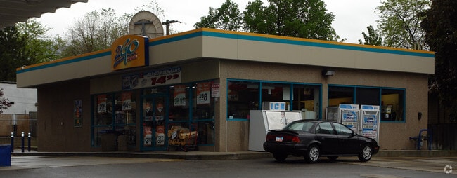
Property Record
2112 E 2100 S, Salt Lake City, UT 84109
NEARBY LISTINGS FOR SALE OR LEASE
Property Detail
2112 E 2100 S
Salt Lake City, UT
IMPS ON: COM N 0^4130 E 244.5 FT FR NW COR LOT 3, BLK 1, COUNTRY CLUB ACRES N 45^2416 E 21.18 FT M OR L; S 89^30 E150 FT; S 0^4130 W 135 FT; N 89^30 W 165 FT; N 0^4130 E120 FT TO BEG. BEING IN NW 1/4 OF NW 1/4, SEC 22-1S-1E.
16-22-107-001-2000
Salt Lake
Storebuilding
Utah
X
3
49035C0302H
0.51 AC
2024
Foothill Corridor
2025
Salt Lake City
104400
DEMOGRAPHICS near 2112 E 2100 S
1 Mile
3 Mile
5 Mile
2024 Total Population
17,164
122,063
266,395
2029 Population
17,378
122,872
270,358
Pop Growth 2024-2029
+ 1.25%
+ 0.66%
+ 1.49%
Average Age
38
38
38
2024 Total Households
6,667
49,681
115,361
HH Growth 2024-2029
+ 1.35%
+ 0.71%
+ 1.77%
Median Household Inc
$101,274
$84,890
$70,511
Avg Household Size
2.50
2.30
2.20
2024 Avg HH Vehicles
2.00
2.00
2.00
Median Home Value
$699,200
$612,334
$584,497
Median Year Built
1955
1957
1968
Nearby Places
Map Layers
Map Styles
 Street
 Aerial
- Restaurants
- Banks
- Shops
- Fitness
- Groceries
PUBLIC TRANSPORTATION
COMMUTER RAIL
North Temple Station (FrontRunner - Utah Transit Authority (UTA))
DRIVE
WALK
Distance
North Temple Station (FrontRunner - Utah Transit Authority (UTA))
15 min
8.6 mi
Warm Springs Relief Point (FrontRunner - Utah Transit Authority (UTA))
DRIVE
WALK
Distance
Warm Springs Relief Point (FrontRunner - Utah Transit Authority (UTA))
16 min
9.9 mi
AIRPORT
Salt Lake City International
DRIVE
WALK
Distance
Salt Lake City International
19 min
12.5 mi
Freight Ports
Port of Stockton
DRIVE
WALK
Distance
Port of Stockton
719 min
702.9 mi
Nearby Properties
Address
Land Use
TOTAL SIZE
Lot Size
Zoning
Address
Land Use
TOTAL SIZE
Lot Size
Zoning
2,287,331 SF
137 AC
I
Address
Land Use
TOTAL SIZE
Lot Size
Zoning
591,924 SF
80.77 AC
I
Address
Land Use
TOTAL SIZE
Lot Size
Zoning
1,262,865 SF
44.15 AC
I
Address
Land Use
TOTAL SIZE
Lot Size
Zoning
530,605 SF
127 AC
RP
Address
Land Use
TOTAL SIZE
Lot Size
Zoning
365,253 SF
33.64 AC
I
Address
Land Use
TOTAL SIZE
Lot Size
Zoning
295,047 SF
113.27 AC
RP
Address
Land Use
TOTAL SIZE
Lot Size
Zoning
185,202 SF
51.07 AC
J
Address
Land Use
TOTAL SIZE
Lot Size
Zoning
298,628 SF
27.30 AC
I
Address
Land Use
TOTAL SIZE
Lot Size
Zoning
299,535 SF
38 AC
I
Address
Land Use
TOTAL SIZE
Lot Size
Zoning
254,939 SF
34.68 AC
I
Address
Land Use
TOTAL SIZE
Lot Size
Zoning
440,898 SF
0.01 AC
RP
Address
Land Use
TOTAL SIZE
Lot Size
Zoning
207,140 SF
23.06 AC
P
Address
Land Use
TOTAL SIZE
Lot Size
Zoning
497,018 SF
13.11 AC
I
Address
Land Use
TOTAL SIZE
Lot Size
Zoning
163,932 SF
14.65 AC
PL
Address
Land Use
TOTAL SIZE
Lot Size
Zoning
257,003 SF
25.87 AC
1108
Address
Land Use
TOTAL SIZE
Lot Size
Zoning
95,666 SF
52.19 AC
I
Address
Land Use
TOTAL SIZE
Lot Size
Zoning
8,042 SF
64.58 AC
RP
Address
Land Use
TOTAL SIZE
Lot Size
Zoning
183,600 SF
10.70 AC
RMF-35
Address
Land Use
TOTAL SIZE
Lot Size
Zoning
249,796 SF
49.02 AC
I
Address
Land Use
TOTAL SIZE
Lot Size
Zoning
115,169 SF
119.06 AC
RP
Address
Land Use
TOTAL SIZE
Lot Size
Zoning
128,997 SF
3.04 AC
ESN
Address
Land Use
TOTAL SIZE
Lot Size
Zoning
297,476 SF
1.62 AC
CSHBD2
Address
Land Use
TOTAL SIZE
Lot Size
Zoning
728,665 SF
0.01 AC
RP
Address
Land Use
TOTAL SIZE
Lot Size
Zoning
40,825 SF
48.09 AC
OS
Address
Land Use
TOTAL SIZE
Lot Size
Zoning
152,660 SF
5.40 AC
I
Address
Land Use
TOTAL SIZE
Lot Size
Zoning
369,717 SF
2.50 AC
RO
Address
Land Use
TOTAL SIZE
Lot Size
Zoning
502,104 SF
4.11 AC
E ST C
Address
Land Use
TOTAL SIZE
Lot Size
Zoning
412,006 SF
1.70 AC
C3
Address
Land Use
TOTAL SIZE
Lot Size
Zoning
369,377 SF
1.65 AC
Address
Land Use
TOTAL SIZE
Lot Size
Zoning
152,579 SF
25.45 AC
I
The World's #1 Commercial Real Estate Marketplace
Connect with us
© 2026 CoStar Group
The information above has been obtained from sources believed reliable. While we do not doubt its accuracy we have not verified it and make no guarantee, warranty or representation about it. It is your responsibility to independently confirm its accuracy and completeness. Any projections, opinions, assumptions, or estimates used are for example only and do not represent the current or future performance of the property. The value of this transaction to you depends on tax and other factors which should be evaluated by your tax, financial, and legal advisors. You and your advisors should conduct a careful, independent investigation of the property to determine to your satisfaction the suitability of the property for your needs.