Property Record
2112 E Highway 82, Gainesville, TX 76240
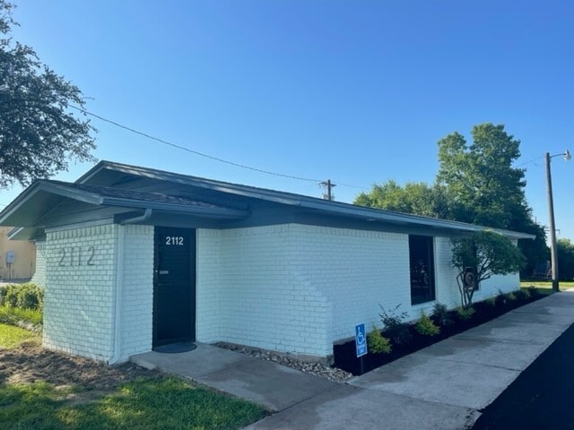


Property Detail
2112 E Highway 82
11899
HARDIN JG 0460 ACRES .6797
Officebuilding
Cooke
B and X Area of moderate flood hazard, usually the area between the limits of the 100-year and 500-year floods.
Texas
2024
0.68 AC
2025
Texas North Area
000600
Other Market Areas
1,838 SF
Gainesville, TX
NEARBY LISTINGS FOR SALE OR LEASE
DEMOGRAPHICS near 2112 E Highway 82
1 mile
3 mile
5 mile
2024 Total Population
4,859
19,981
22,512
2029 Population
5,088
21,090
23,756
Pop Growth 2024-2029
+ 4.71%
+ 5.55%
+ 5.53%
Average Age
39
38
38
2024 Total Households
1,907
7,335
8,259
HH Growth 2024-2029
+ 4.77%
+ 5.59%
+ 5.57%
Median Household Inc
$54,861
$57,166
$59,052
Avg Household Size
2.40
2.60
2.60
2024 Avg HH Vehicles
2.00
2.00
2.00
Median Home Value
$193,695
$181,543
$186,991
Median Year Built
1974
1971
1973
Nearby Places
Map Layers
Map Styles
 Street
 Aerial
Transit
 Traffic
 Biking
Places
Listings with unknown addresses are not visible on the map
- Restaurants
- Banks
- Shops
- Fitness
- Groceries
PUBLIC TRANSPORTATION
COMMUTER RAIL
Drive
Walk
Distance
5 min
2.5 mi
Nearby Properties
Address
Land Use
TOTAL SIZE
Lot Size
Zoning
Address
Land Use
TOTAL SIZE
Lot Size
Zoning
78,598 SF
2.90 AC
Address
Land Use
TOTAL SIZE
Lot Size
Zoning
121,605 SF
Address
Land Use
TOTAL SIZE
Lot Size
Zoning
133,708 SF
47.68 AC
Address
Land Use
TOTAL SIZE
Lot Size
Zoning
58,770 SF
26.40 AC
Address
Land Use
TOTAL SIZE
Lot Size
Zoning
402,800 SF
Address
Land Use
TOTAL SIZE
Lot Size
Zoning
208,499 SF
33.91 AC
Address
Land Use
TOTAL SIZE
Lot Size
Zoning
46,927 SF
2.50 AC
Address
Land Use
TOTAL SIZE
Lot Size
Zoning
12,346 SF
9.85 AC
Address
Land Use
TOTAL SIZE
Lot Size
Zoning
6,939 SF
10.58 AC
Address
Land Use
TOTAL SIZE
Lot Size
Zoning
63,038 SF
30 AC
Address
Land Use
TOTAL SIZE
Lot Size
Zoning
116,474 SF
10.60 AC
Address
Land Use
TOTAL SIZE
Lot Size
Zoning
2,694 SF
7.31 AC
Address
Land Use
TOTAL SIZE
Lot Size
Zoning
20,818 SF
3.92 AC
Address
Land Use
TOTAL SIZE
Lot Size
Zoning
11,096 SF
2.59 AC
Address
Land Use
TOTAL SIZE
Lot Size
Zoning
50,021 SF
2.33 AC
Address
Land Use
TOTAL SIZE
Lot Size
Zoning
135,760 SF
13.51 AC
Address
Land Use
TOTAL SIZE
Lot Size
Zoning
41,472 SF
1.67 AC
Address
Land Use
TOTAL SIZE
Lot Size
Zoning
32,875 SF
5.84 AC
Address
Land Use
TOTAL SIZE
Lot Size
Zoning
126,570 SF
27.93 AC
Address
Land Use
TOTAL SIZE
Lot Size
Zoning
108,208 SF
7.49 AC
Address
Land Use
TOTAL SIZE
Lot Size
Zoning
60,254 SF
1.76 AC
Address
Land Use
TOTAL SIZE
Lot Size
Zoning
18,082 SF
6.81 AC
Address
Land Use
TOTAL SIZE
Lot Size
Zoning
53,032 SF
1.61 AC
Address
Land Use
TOTAL SIZE
Lot Size
Zoning
9,552 SF
5.22 AC
Address
Land Use
TOTAL SIZE
Lot Size
Zoning
14,400 SF
2.66 AC
Address
Land Use
TOTAL SIZE
Lot Size
Zoning
Address
Land Use
TOTAL SIZE
Lot Size
Zoning
11,880 SF
3 AC
Address
Land Use
TOTAL SIZE
Lot Size
Zoning
70,076 SF
19.20 AC
Address
Land Use
TOTAL SIZE
Lot Size
Zoning
375.74 AC
The World's #1 Commercial Real Estate Marketplace
Connect with us
© 2026 CoStar Group
The information above has been obtained from sources believed reliable. While we do not doubt its accuracy we have not verified it and make no guarantee, warranty or representation about it. It is your responsibility to independently confirm its accuracy and completeness. Any projections, opinions, assumptions, or estimates used are for example only and do not represent the current or future performance of the property. The value of this transaction to you depends on tax and other factors which should be evaluated by your tax, financial, and legal advisors. You and your advisors should conduct a careful, independent investigation of the property to determine to your satisfaction the suitability of the property for your needs.